
Endert
| Endert | ||
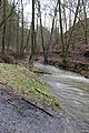
 Die Rausch waterfall in the upper Endert valley |
||
| Data | ||
| Water code | EN : 2692 | |
| location | Rhineland-Palatinate , Germany | |
| River system | Rhine | |
| Drain over | Moselle → Rhine → North Sea | |
| source | Northeast of elms | |
| Source height | approx. 494 m above sea level NN | |
| muzzle | In Cochem in the Moselle Coordinates: 50 ° 8 ′ 51 ″ N , 7 ° 10 ′ 3 ″ E 50 ° 8 ′ 51 ″ N , 7 ° 10 ′ 3 ″ E |
|
| Mouth height | approx. 84 m above sea level NN | |
| Height difference | approx. 410 m | |
| Bottom slope | approx. 18 ‰ | |
| length | 22.3 km | |
| Catchment area | 74.207 km² | |
The Endert , also called Endertbach , is a 22.3 km long left tributary of the Moselle in Rhineland-Palatinate .
course
The Endert rises in the Eifel north-east of Ulmen near the A 48 and then flows in a south-easterly direction mainly away from roads through a narrow forest valley. In Cochem , the only village directly on the river, the small river flows into the generally northeast-facing Moselle .
Worth seeing
Among the attractions at the Endertplatz in the upper part of the valley include Martental the Sanctuary of Maria Martental and 7 meters high Endert case , the noise , and in the middle, increasingly deeply cut into the Eiffel landscape section the gorge-like scenery. The lower section of the valley is dominated by the ruins of Winneburg and the Reichsburg Cochem , which overlooks the estuary .
Development
The hiking trail running along the Endert is part of the 75 km long Karolingerweg from Prüm to Cochem.
The Endert near Martental
