Eniwa (volcano)
| Eniwa | ||
|---|---|---|

|
||
| height | 1320 m TP | |
| position | Chitose , Hokkaido | |
| mountains | Nasu Volcanic Belt | |
| coordinates | 42° 47′ 36″ N , 141° 17′ 8″ E | |
|
|
||
| Type | stratovolcano | |
| rock | andesite | |
| age of the rock | holocene | |
| Last eruption | circa 1707 | |
| development | trail | |
| particularities | Part of Shikotsu-Toya National Park | |
Mount Eniwa (恵庭岳, Eniwa-dake ) is a volcano on the Japanese island of Hokkaidō . It is 1320 m high, is located in the urban area of Chitose south of Sapporo and is part of the Shikotsu-Toya National Park . Part of the Nasu Volcanic Belt, Eniwa lies on the north-west shore of Lake Shikotsu and was one of the venues for the 1972 Winter Olympics .
geology
Eniwa is composed mostly of andesite and is listed as an active volcano by the Japan Meteorological Agency . It is located on the northwestern shore of Lake Shikotsu , which it towers 1073 meters above. This crater lake forms the center of a caldera that includes the Tarumae and Fuppushi volcanoes on the south shore, in addition to Mount Eniwa. On the west side of the Eniwa lies the small Okotan Lake.
The caldera was formed by a Plinian eruption about 40,000 years ago . 20,000 years ago, a lava dome began to form within the caldera wall due to the ejection of pumice . Lava flows flowed near the summit and down the west and east sides, while volcanic ash covered vast tracts of land. Radiocarbon measurements show that the last magmatic eruption to date occurred around 2000 years ago. After a long period of inactivity, there were first phreatic explosions in crater 1 around 1500 (± 150 years). These occurred again around 1550 (± 75 years) in crater 2 and around 1707 (± 30 years) in crater 3. These three events all had a value of 2 on the Volcanic Explosivity Index . Since then, Eniwa has been dormant again as volcanic activity has shifted to Tarumae.
1972 Winter Olympics
The downhill races of the 1972 Winter Olympics took place on the Eniwa, since there was no slope with a sufficiently large difference in altitude on the Teine , the venue for the giant slaloms and slaloms . The organizing committee prioritized the geographical compactness of the sports venues and short distances over environmental protection. It chose the south-western flank of Mount Eniwa (about 35 km south of the Olympic Village) and did not consider already developed but distant locations such as Niseko or Furano . Conservationists petitioned IOC President Avery Brundage to stop the clearing of 29 hectares of forest, but to no avail. After all, the organizing committee committed itself to restoring the natural state after the Winter Games.
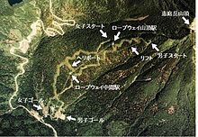
The work began in July 1968. It included the clearing of two 20 to 60 m wide aisles, the construction of a gondola lift up to 990 m TP and a subsequent chair lift up to 1106 m TP - Press center , grandstands , TV commentator booths, two start and two finish houses, helipad , parking lots and podium for the Olympic flame . In total, the facilities cost 834 million yen (adjusted for inflation: 7.662 million euros in 2018).
The pistes were used for the first time during the International Winter Sports Week in February 1971, which served as a kind of dress rehearsal. There were two Swiss victories at the Olympic races on February 5 and 7, 1972 by Marie-Theres Nadig and Bernhard Russi .
| discipline | length | begin | aim | difference in height |
max slope |
|---|---|---|---|---|---|
| departure men | 2636 m | 1126 m TP | 354 m TP | 772 m | 37° |
| departure women | 2108 m | 870 m TP | 336 m TP | 534 m | 35° |
The fact that they were only used for a short time shows how unsustainable the downhill slopes were. As soon as the Olympic races were over, the demolition of the mountain railways and buildings began. The subsequent reforestation program lasted until 1986 and cost 240 million yen (about US$2.5 million in 2018). The State Forest Service planted Sakhalin spruce instead of the Ayan spruce commonly found on the Eniwa because the latter species was no longer available for seedlings . Four decades after the Winter Games, local media reported that the aisles were now overgrown, but that the new forest remained more like a plantation and that it would probably take a hundred years before it was fully restored to its natural state.
Surname
In the Ainu language , the volcano is called E-en-iwa , which can be translated as "pointed mountain". Over time, this shortened to Eniwa in Japanese. The volcano is referred to as Chitose-take (千歳嶽) on the 1893 topographical map of the Land Survey Authority (scale 1:200,000), and Eniwa on the revised 1926 edition .
mountain trail
Eniwa can be climbed from the east via a mountain trail. It starts near Poroponai Park on the lake shore and gradually gets steeper as you get closer to the summit. The tree line is at an altitude of around 800 m. From there the terrain is alpine and rocky. The ascent takes three to three and a half hours.
Mining
There are gold and silver deposits around the Eniwa , which have been exploited in three mines : Eniwa Mine and Hikariryū Mine on the north side, and Chitose Mine on the east side. Age measurements using the potassium-argon method showed that the deposits are around 40 million years old and thus significantly older than the volcano. The first veins were discovered in 1899, and commercial mining began in 1935. Since there were no roads in the area at the time, the ores had to be transported by barge to the other side of the lake and from there to Tomakomai by the Ōji narrow-gauge railway . In 1943 the government forced the closure of all gold and silver mines in order to concentrate mining resources on commodities essential to the war effort. After the end of the war, the Eniwa mine remained permanently closed, while mining at the Hikariryū mine and the Chitose mine resumed and continued until 1986 and 2006, respectively.
web links
- Geological Bureau data sheet (Japanese)
itemizations
- ↑ Eniwadake. (PDF, 984 kB) Japan Meteorological Agency , accessed 2 September 2018 (English).
- ↑ Shikotsu. In: Global Volcanism Program. Smithsonian Institution , 2013, accessed September 2, 2018 (English).
- ↑ a b Junko Tahara: Japanese challenges for environmental protection in the Olympic movement . In: Michael Chia, Jasson Chiang (eds.): Sport Science and Studies in Asia . World Scientific Publishin, Singapore 2010, ISBN 978-981-4304-08-5 , pp. 287-289 . On-line
- ↑ Official report. (PDF, 43.3 MB) Organizing Committee of the XI. 1972 Winter Olympics, 1973 pp. 281–284 , retrieved 2 September 2018 (English).
- ↑ a b Currency conversions as of February 1, 1972 according to Historical Calculators. fxtop.com, accessed 4 September 2018 .
- ↑ Official report of the XI. 1972 Winter Olympics. p. 284.
- ↑ アイヌ語地名リスト. (PDF, 91 kB) Hokkaidō Prefecture, p. 19 , retrieved 2 September 2018 (Japanese).
- ↑ Shuzō Yamada:北海道の地名. Hokkaidō Shimbunsha, Sapporo 1984, ISBN 4-89363-321-X , p. 57 .
- ↑ 山は博物館. In: Mainichi Shimbun (Hokkaidō Edition), 19 August 2012, p. 22.
- ↑ Robert Storey: North-East Asia on a Shoestring . Lonely Planet , Melbourne 1998, ISBN 0-86442-135-4 , pp 327 .
- ↑ Chitose History Commission (ed.): 新千歳市史. Chitose, 2010, pp. 44–45.
- ↑ Masahiro Asada:北海道金鉱山史研究. University of Hokkaidō , Sapporo 1999, ISBN 4-8329-6021-0 , pp. 231-288 .


