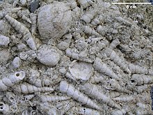
Erminger Turritellenplatte
Coordinates: 48 ° 23 ′ 21 ″ N , 9 ° 53 ′ 34 ″ E
The Ermingen Turritellenplatte is a mass accumulation of fossil shells of the tower snail Turritella turris from the time of the lower Miocene in the Ulm district of Ermingen ( Hochsträß ) on the northern edge of the southern German Molasse basin . The length of the Turritellen plate is only a few hundred meters, its greatest thickness 6 m.
The Erminger Turritellenplatte in its entirety, including the main Stockert site , has been a protected extensive geological ground monument ( geotope ) of the Tübingen administrative district since 1980 . The first station of the Ermingen nature trail offers more information on information boards . Due to its hardness and weather resistance, the rock was previously used by the inhabitants of Ermingen as a building material, as is evidenced by the countless pits in which the rock was mined in the Ermingen Forest. A large part of the area has been protected from robbery excavations by a fence for several years.
The sediments of the Ermingen Turritellenplatte were deposited around 18.5 million years ago, in the early Ottnangian , under shallow marine conditions near the coast. The bathyal sharks Notorhynchus primigenius and Mitsukurina lineata detected there indicate both good connections to deep water regions and a good food supply in the deposit area of the later Turritellen plate. Rose quartz and silica slate as detritic components probably come from a region shaped by Moldanubian-Saxothurigian basement rocks. The Turritellenplatte corresponds petrographically and stratigraphically to the rough limestone that is present in Hegau and the Tennikerfluh ( Sissach district , canton Basel-Landschaft ).
literature
- Johannes Baier: The scientific research of the Erminger Turritellenplatte (Hochstrasse) in the 19th century . Geohistorical sheets. Vol. 27, 2016, pp. 25-39.
Individual evidence
- ↑ Johannes Baier: About the tertiary education in the Ulm area. Documenta Naturae 168. Munich 2008, ISBN 978-3-86544-168-3 .
- ↑ a b Ermingen natural monument The Turritellenplatte . ( Memento of March 5, 2016 in the Internet Archive ) Website of the village of Ermingen
- ^ Manfred Schöttle, Hans-Dieter Bergner, Georg Burgmeier, Thomas Huth: Geotopes in the administrative region of Tübingen, profiles. State Institute for the Environment, Measurements and Nature Conservation Baden-Württemberg (LUBW), Karlsruhe 2007 ( online ), p. 963.
- ↑ Ermingen Nature Trail Turritellenplatte.de - Website of the Mineral and Fossil Friends Ulm / Neu-Ulm eV
- ↑ The Erminger Turritellenplatte . Turritellenplatte.de - Website of the Mineral and Fossil Friends Ulm / Neu-Ulm eV
- ^ A b Johannes Baier: A contribution to the Erminger Turritellenplatte (Middle Swabian Alb, SW Germany). Annual reports and communications from the Upper Rhine Geological Association, new series. Vol. 90, 2008, pp. 9-17 doi: 10.1127 / jmogv / 90/2008/9
- ↑ Johannes Baier, Karl-Heinz Schmitt and Rudi Mick: Notes on the sub-Miocene shark and ray fauna of the Erminger Turritellenplatte (Middle Swabian Alb, SW Germany). Annual reports and communications from the Upper Rhine Geological Association, new series. Vol. 86, 2004, pp. 361-371, doi: 10.1127 / jmogv / 86/2004/361 .
- ↑ Johannes Baier: The geology of the Ulm area. Documenta Naturae 173. Munich 2009, ISBN 978-3-86544-173-7 .
Web links
- Geotope profile of the State Office for Geology, Raw Materials and Mining (LGRB)
- Michael W. Rasser & James H. Nebelsick: The Erminger Turritellenplatte. - HTML version of an article published in the journal Fossilien (issue 4/2006) about the excavation in the Turritellenplatte in 2005

