
Finzbach
|
Finzbach Finz |
||
 Finzbach shortly before the weir system |
||
| Data | ||
| Water code | DE : 16132 | |
| location | Garmisch-Partenkirchen district | |
| River system | Danube | |
| Drain over | Isar → Danube → Black Sea | |
| source |
Ester Mountains 47 ° 30 ′ 52 ″ N , 11 ° 10 ′ 14 ″ E |
|
| muzzle | At Wallgau in the Isar Coordinates: 47 ° 31 ′ 6 ″ N , 11 ° 17 ′ 45 ″ E 47 ° 31 ′ 6 ″ N , 11 ° 17 ′ 45 ″ E
|
|
| length | 13 km | |
| Catchment area | 37.39 km² | |
| Left tributaries | Tränkgraben, Höllenbach, Markgraben, Angerlgraben, Altgraben, Finzaugraben, Jungfinz, Steglegraben, Haselbach | |
| Right tributaries | Schneiderlochgraben, Rindberggraben, Bauerngraben | |
| Communities | Wallgau , Krün | |
 Catchment area of the Finzbach |
||
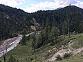
The Finzbach is a 13 km long torrent in the Bavarian Alps and a tributary of the Isar . The headwaters are in the Estergebirge , near the Esterbergalm. To the east of Wallgau , the Finzbach flows into the Isar on the left. The main tributaries of the Finzbach are the Altgraben and Jungfinz.
In the middle reaches the "Finz" flows through the Finzbachklamm on its way.
At the end of this gorge , the stream is dammed by a weir system and its water is fed to the Isar transfer canal (Obernach Canal ) through a pipeline system to which the Jungfinz is also connected . This Isar transfer canal also crosses the Finzbach by means of a culvert on the southern outskirts of Wallgau.
In the early 1970s, the lower course of the stream from the culvert to the confluence with the Isar was built to make it flood-proof.
photos

Finzbach at the confluence of the Angerlgraben. In the background the Schöttelkarspitze (left) and the Wörner (right)
Finzbach near the Finzalm (right)

Finzbach in the Finzbachklamm

Weir system in the Finzbachklamm
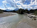
The Finzbach flows into the Isar (dry creek bed on the right)


