
Fish river
| Fish river | ||
 Fish river at Gibeon |
||
| Data | ||
| location | Namibia | |
| River system | Orange | |
| Drain over | Orange → Atlantic | |
| source | Naukluft Mountains | |
| Source height | 1400 m | |
| muzzle |
Orange River , 7 km south of the Verneukberg coordinates: 28 ° 6 '0 " S , 17 ° 10' 30" O 28 ° 6 '0 " S , 17 ° 10' 30" O |
|
| Mouth height | 55 m | |
| Height difference | 1345 m | |
| Bottom slope | 2.1 ‰ | |
| length | 650 km | |
| Catchment area | 54,326.103 km² | |
| Left tributaries | Lion river | |
| Right tributaries | Konkiep | |
| Reservoirs flowed through | Hardap reservoir | |
.jpg)
The Fish River ( English Fish River , Afrikaans : Visrivier ) is 650 kilometers in length, the longest river and a water catchment area in Namibia . As a rivier, it periodically carries water and is not navigable. The geographer Roger Swart describes the fish river as "the only almost constantly water-bearing river" in the interior of Namibia.
The catchment area is 54,326.103 km².
geography
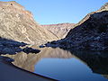
The fish river has its source in the eastern Naukluft Mountains in Hardap and is dammed near Mariental by the Hardap dam (and also from 2017 by the Neckartal dam ). It then flows through the towns of Mariental , Gibeon and Seeheim and in its lower third forms the Fish River Canyon , which is the second largest canyon in the world after the Grand Canyon . It is flanked by the Hunsberg mountains such as the Verneukberg . The fish river finally flows southwest of ǀAi-ǀAis into a border river to South Africa, the Orange River . This flows into the Atlantic about 100 kilometers further.
The tributaries of the fish river include:
tourism
The Fish River is accessible to tourists by an 85-kilometer hiking trail from Hobas to ǀAi-ǀAis . This “trail” can be run in the winter months during the dry season. There are also numerous accommodation facilities on the lower reaches of the Fish River, including those from Namibia Wildlife Resorts .
gallery
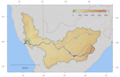
The catchment area of the Fish River, shown together with the Orange River
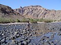
Fish river in the Fish River Canyon


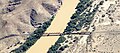
Railway bridge over the Fish River near Seeheim (2018)


.jpg)
Web links
- The Greater Fish River Canyon Landscape (English)
Individual evidence
- ^ Roger Swart: An earth science review of the Orange-Fish River Basin, Namibia. Desert Research Foundation of Namibia, 2008, p. 19.
- ↑ Mapping the Major Cathments of Namibia. Ben Ben J. Strohbach, National Botanical Research Institute.
- ↑ Fish River Canyon - The second largest canyon in the world. Retrieved August 13, 2019 .