Fischingen TG
| TG is the abbreviation for the canton of Thurgau in Switzerland and is used to avoid confusion with other entries of the name Fischingen . |
| Fischingen | |
|---|---|
| Country: |
|
| Canton : | Thurgau (TG) |
| District : | Münchwilen |
| Postal code : | 8376 |
| BFS no. : | 4726 (Political Community) |
| former BFS no .: | 4728 (local parish ) |
| UN / LOCODE : | CH AUU |
| Coordinates : | 715308 / 252884 |
| Height : | 625 m above sea level M. |
| Area : | 30.58 km² ( Polish municipality) 3.43 km² (local municipality) |
| Residents: | 2792 (December 31, 2018) |
| Population density : | 91 inhabitants per km² |
| Website: | www.www.fischingen.ch |
|
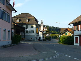
Fischingen with the monastery in the background |
|
| map | |
Fischingen is a municipality and a village in the Münchwilen district and the southernmost municipality in the Swiss canton of Thurgau .
The political community was created in 1972 through the merger of the municipality Fischingen with their local communities Au , Dussnang , Fischingen, Oberwangen and Tannegg to form a unified municipality Fischingen.
geography
The municipality is located at the northern foot of the Hörnli in the transition area from the Swiss plateau to the foothills of the Alps . The Murg flows through it and forms the largest municipality in Thurgau, with half of the area being forest. The southernmost point of the municipality of Fischingen and thus also of the canton of Thurgau is the Dreiländerstein on the Silberbüel near the Ergeten nature reserve. It forms the inner Swiss canton border between the cantons of Thurgau , St. Gallen and Zurich . A little east of it, on the Fischinger Grat , also called Hohgrat or Groot, is located at 991 m above sea level. M. the highest point in the canton of Thurgau, accessible on foot from Allenwind.
The Fischingen community has numerous outdoor courtyards and a 90 km long road and water network to maintain. The administration is based in Dussnang in the parish hall near the Kurhaus.
history
The village of Fischingen arose north of the monastery , which was founded shortly before 1138 , as it was called nova cella Vishina at that time. It made with Bichelsee , Balterswil , Ifwil and probably Au the so-called old Fischinger Court ( opening 1432) and was the Tannegg Office , closely linked, which acquired the monastery 1,693th Fischingen received church supplies from the monastery. The reformed minority belonged to Dussnang .
Located on the way to Einsiedeln , Fischingen developed into a place of pilgrimage with the Idda cult in the 16th and 17th centuries , which enlivened the modest market, the hospitality industry and the handicrafts. In 1803 the municipal and local parishes were created . In 1848 the monastery was closed and the monastery church was handed over to the now independent parish .
Weaving was widespread in the 19th century and embroidery around 1900 , as cattle breeding and the timber industry did not offer sufficient income. The former monastery was used as a colored weaving mill from 1852. In 1879 the St. Iddazell Association set up an orphanage in it, from which the Chilberg special school home, which was newly built in 1976, emerged.
Today's political municipality was created in 1972 from the merger of the local communities Au , Dussnang , Fischingen, Oberwangen and Tannegg . With the merger of the municipalities, the financial situation could be improved and the emigration from the economically weak peripheral region stopped.
The children's home in Fischingen, which is affiliated to the monastery, came under public criticism in 2013 because the children in the home were exposed to illegal drug trials in connection with the state psychiatric clinic in Münsterlingen in the early 1970s .
→ see also the history sections in the articles Au TG , Dussnang , Oberwangen TG and Tannegg
coat of arms
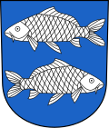
Blazon : In blue two white fish swimming past one another.
The coat of arms of the former municipality Fischingen and the political municipality Fischingen was taken over from Fischingen monastery.
Population and economy
In 2016, Fischingen offered 1062 jobs (converted to full-time positions). Of these, 13.6% were employed in agriculture and forestry, 40.5% in industry, trade and construction and 45.9% in the service sector. Numerous small and medium-sized businesses and around 90 agricultural businesses dominate the municipality's economy. In the third economic sector , the Kurhaus Dussnang is important. Fischingen with the hiking area on the Hörnli and the renovated monastery complex is a destination for pilgrims and hikers on the Way of St. James . In the monastery complex there is the high baroque tomb of St. Idda as a cultic center.
 |
| 1850 | 1900 | 1910 | 1950 | 1970 | 1980 | 2000 | 2010 | 2018 | |
|---|---|---|---|---|---|---|---|---|---|
| Political community | 2100 | 2605 | 2581 | 2783 | |||||
| Municipal parish | 2125 | 2570 | 2665 | 2484 | 2248 | ||||
| Local parish | 405 | 717 | 812 | 643 | 588 | ||||
| source | |||||||||
Of the total of 2,783 inhabitants in the Fischingen community in 2018, 225 or 8.1% were foreign nationals. 1306 (46.9%) were Roman Catholic and 838 (30.1%) Protestant Reformed. Fischingen had 418 residents at that time.
Attractions
Fischingen is listed in the inventory of places worthy of protection in Switzerland .
- The monastery Fischingen was founded in the 1138th Its baroque church was rebuilt in 1685–1687.
- The castle and today's ruins of Tannegg was built around 1240.
- The Landstieg art collection in Oberwangen shows contemporary glass and ceramic works, especially from the studio glass movement .
Personalities
- Franziskus Fröhlicher (1774–1848), last abbot of Fischingen monastery
- Franziskus von Streng (1884–1970), Roman Catholic bishop in the diocese of Basel , born in Fischingen
- Jürg Stahl (* 1968), SVP politician, citizen of Fischingen
Web links
Individual evidence
- ↑ a b Thurgau in figures 2019 . On the website of the Statistical Office of the Canton of Thurgau (PDF file; 1.8 MB), accessed on April 28, 2020.
- ↑ Swiss land use statistics. Completed on July 1, 1912. Published by the Federal Statistical Bureau. ( Memento from April 12, 2016 in the Internet Archive )
- ↑ Permanent and non-permanent resident population by year, canton, district, municipality, population type and gender (permanent resident population). In: bfs. admin.ch . Federal Statistical Office (FSO), August 31, 2019, accessed on December 22, 2019 .
- ↑ a b Localities and their resident population. Edition 2019 . On the website of the Statistical Office of the Canton of Thurgau (Excel table; 0.1 MB), accessed on April 28, 2020.
- ↑ New highest point of the canton Thurgau hikr.org, accessed on May 11, 2016
-
^ A b Gregor Spuhler : Fischingen (community). In: Historical Lexicon of Switzerland .
These sections are largely based on the entry in the Historical Lexicon of Switzerland (HLS), which, according to the HLS's usage information, is under the Creative Commons license - Attribution - Share under the same conditions 4.0 International (CC BY-SA 4.0). - ↑ Human experiments - How many scruples does research need? , SWR 2 report from May 30, 2015
- ↑ a b municipal coat of arms . On the website of the State Archives of the Canton of Thurgau, accessed on December 8, 2019
- ↑ Worth knowing. Fischingen - attractive rural living space close to large centers. On the website of the Fischingen community, accessed on October 25, 2019
- ↑ a b Population development of the municipalities. Canton Thurgau, 1850–2000 and resident population of the municipalities and change from the previous year. Canton of Thurgau, 1990–2018. On the website of the Statistical Office of the Canton of Thurgau (Excel tables; 0.1 MB each), accessed on April 28, 2020.
← Previous location: Oberwangen TG | Fischingen TG | Next town: Fischingen Monastery →


