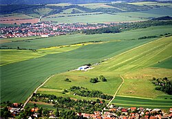
Bad Frankenhausen airfield
| Bad Frankenhausen airfield | |
|---|---|

|
|
| Characteristics | |
| ICAO code | EDOF |
| Coordinates | |
| Height above MSL | 240 m (787 ft ) |
| Transport links | |
| Distance from the city center | 1 km west of the Udersleben district , 3 km east of Bad Frankenhausen |
| Street | L 1172 |
| Basic data | |
| opening | k. A. |
| operator | ACF Aeroclub Hans Grade eV |
| Flight movements |
Motor and glider flight |
| Start-and runway | |
| 08/26 | 650 m × 30 m grass |
The airfield Bad Frankenhausen is a small special airfield east of Bad Frankenhausen . It is operated by the ACF Aeroclub Hans Grade eV .
geography
The course is located in the northern part of Thuringia between Bad Frankenhausen and the district of Udersleben ; it can easily be found from the air in the triangle between Panorama , Kyffhäuser Monument and the gravel pit.
Flight operations
In summer, flight operations take place from 9:00 a.m. to 4:00 p.m. UTC ; there is usually no flight operation in winter. Every year there is an airfield festival, a parachutist meeting and a large kite festival on the airfield. It may Motorplanes ( MTOW <5700 kg), helicopters , motor gliders (GLDP), balloons and Ultralight start (UL) and land.
Infrastructure
In most cases aircraft are hangars on request. Aircraft can also be parked outdoors overnight.
Directions
The airfield can be reached via Landstrasse 1172. From Esperstedt there are signs that make it easier to get there.