
Fontanges
| Fontanges | ||
|---|---|---|
|
||
| region | Auvergne-Rhône-Alpes | |
| Department | Cantal | |
| Arrondissement | Mauriac | |
| Canton | Mauriac | |
| Community association | Pays de Salers | |
| Coordinates | 45 ° 7 ′ N , 2 ° 30 ′ E | |
| height | 664-1,246 m | |
| surface | 18.04 km 2 | |
| Residents | 199 (January 1, 2017) | |
| Population density | 11 inhabitants / km 2 | |
| Post Code | 15140 | |
| INSEE code | 15070 | |
 Town hall ( Mairie ) of Fontanges |
||

Fontanges is a French municipality with 199 inhabitants (at January 1, 2017) in the department of Cantal in the region of Auvergne Rhône-Alpes (before 2016 Auvergne ). It belongs to the canton of Mauriac (until 2015 Salers ) and the arrondissement of Mauriac . The inhabitants are called Fontangeois .
location
Fontanges is about 24 kilometers north-northeast of Aurillac . Neighboring communities are Saint-Paul-de-Salers in the north, Le Fau in the east, Saint-Projet-de-Salers in the south and Saint-Martin-Valmeroux in the west.
Population development
| year | 1962 | 1968 | 1975 | 1982 | 1990 | 1999 | 2006 | 2011 | 2016 |
|---|---|---|---|---|---|---|---|---|---|
| Residents | 509 | 454 | 353 | 307 | 292 | 241 | 223 | 212 | 202 |
| Source: Cassini and INSEE | |||||||||
Attractions
- Saint-Vincent church from 1468, monument historique since 1927
- Saint-Michel chapel, carved into the rock in 1867
- Lamarge Castle from the 14th century, monument historique since 1986
- Palmont Castle, built in 1480, has been a monument historique since 1970

Saint Vincent Church
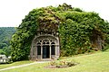
Saint-Michel chapel

Lamargé Castle


Web links
Commons : Fontanges (Cantal) - Collection of images, videos and audio files