
Photo
| Photo | ||||||
|
||||||
| State : | Sweden | |||||
| Province (län): | Västra Götalands län | |||||
| Historical Province (landskap): | Bohuslan | |||||
| Municipality : | Öckerö | |||||
| Coordinates : | 57 ° 40 ′ N , 11 ° 39 ′ E | |||||
| SCB code : | 4348 | |||||
| Status: | Crime scene | |||||
| Residents : | 630 (December 31, 2015) | |||||
| Area : | 0.43 km² | |||||
| Population density : | 1465 inhabitants / km² | |||||
| List of perpetrators in Västra Götaland County | ||||||

Fotö is a place ( tätort ) in the Swedish province of County of Västra Götaland and the historical province of Bohuslän .
The name also refers to the island in the Gothenburg archipelago on which the place is located. It belongs to the municipality of Öckerö and is located in the Kattegat west of Gothenburg . Both in east-west and north-south direction, it extends about one kilometer. Fotö is connected to the neighboring island of Hönö to the north by a bridge . There is a harbor on the south side of Fotös. A bathing beach extends on the east side.
The population of the village of Fotö has increased significantly since the 1960s, from 368 in 1960 to 630 in 2015.
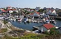
Port of Fotö

Bridge to Hönö

View from the south


