Franchevelle
| Franchevelle | ||
|---|---|---|
|
|
||
| region | Bourgogne-Franche-Comté | |
| Department | Haute-Saône | |
| Arrondissement | Lure | |
| Canton | Lure-1 | |
| Community association | Triangle Vert | |
| Coordinates | 47 ° 44 ′ N , 6 ° 28 ′ E | |
| height | 283-350 m | |
| surface | 10.42 km 2 | |
| Residents | 428 (January 1, 2017) | |
| Population density | 41 inhabitants / km 2 | |
| Post Code | 70200 | |
| INSEE code | 70250 | |
 Mairie Franchevelle |
||
Franchevelle is a municipality in the French department of Haute-Saône in the region Bourgogne Franche-Comté .
geography
Franchevelle is located at an altitude of 294 m above sea level, seven kilometers north-northwest of Lure and about 26 kilometers northeast of the city of Vesoul (as the crow flies). The village extends in the eastern part of the department, on the southern edge of the Luxeuil plain, on the Lanterne , on the northern edge of the Bois de Franches Communes .
The area of the 10.42 km² municipal area includes a section of the Luxeuil plain. The main part of the area is taken up by this alluvial plain , which averages 290 m. The most important watercourse is the Lanterne, which crosses the area from east to west and provides drainage to the Saône . Agricultural use predominates at this level.
To the north, the area extends over the plain and the lowland of the Lambier to the edge of the Grand Bois . There are numerous ponds here, most of which have been dammed and are used for fish farming, including the Étang de la Maisonnette . South of the village, the terrain rises slightly to the plateau of the extensive forest area Bois des Franches Communes . At 350 m, the highest point in Franchevelle is reached in this forest on the ridge of the Monts Reveaux .
In addition to the actual town, Franchevelle includes the following settlements:
- La Boiche (303 m) on the plain north of Franchevelle
- Bois-Derrière (305 m) in the Lambier valley south of the Grand Bois
Neighboring communities of Franchevelle are Citers and Rignovelle in the north, Linexert and Saint-Germain in the east, Lure in the south and Quers in the west.
history
Remains of a Roman traffic route indicate an early inspection and possibly also settlement of the area. In 1173 the hospitallers founded a hospital. However, Franchevelle was first mentioned in a document in 1278 under the name La Franchevile . The spellings La Franchvile and Fransche Vile (1308) have survived from a later period . In the Middle Ages Franchevelle belonged to the Free County of Burgundy and in it to the area of the Bailliage d'Amont . Together with Franche-Comté , the village finally came to France with the Peace of Nijmegen in 1678. During the Second World War, part of the town was set on fire by German troops in 1944. Today Franchevelle is a member of the community association Communauté de communes des Franches-Communes, which comprises 14 localities .
Attractions
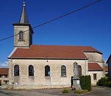
Saint-Vaudre, the village church of Franchevelle, was rebuilt in the 19th century. The furnishings include the pulpit and altars from the 18th century, a statue of Christ and a statue of Saint Vaudre from the 17th century.
From de Fort Vougne and the former manor are preserved only few remains. Other sights include a renaissance cross near the former castle and a 1000 year old cross in the Grand Bois .
population
| Population development | |
|---|---|
| year | Residents |
| 1962 | 266 |
| 1968 | 264 |
| 1975 | 242 |
| 1982 | 233 |
| 1990 | 296 |
| 1999 | 310 |
| 2006 | 348 |
With 428 inhabitants (January 1, 2017) Franchevelle is one of the small communities in the Haute-Saône department. After the population had decreased significantly in the first half of the 20th century (554 people were counted in 1881), the population has continued to grow steadily since the beginning of the 1980s.
Economy and Infrastructure
Until well into the 20th century, Franchevelle was primarily a village characterized by agriculture (arable farming, fruit growing and cattle breeding), forestry and fish farming. Today the cultivation of blueberries is important. There are also some local small businesses. In the last few decades the village has transformed into a residential community. Many workers are therefore commuters who work in the larger towns in the area.
The village is well developed in terms of traffic. It is located near the main road D64, which leads from Lure to Luxeuil-les-Bains and which has four lanes in this section. Other road connections exist with Quers, Lure, Linexert and Rignovelle.

