Freyung
| coat of arms | Germany map | |
|---|---|---|

|
Coordinates: 48 ° 48 ' N , 13 ° 33' E |
|
| Basic data | ||
| State : | Bavaria | |
| Administrative region : | Lower Bavaria | |
| County : | Freyung-Grafenau | |
| Height : | 655 m above sea level NHN | |
| Area : | 48.64 km 2 | |
| Residents: | 7171 (Dec. 31, 2019) | |
| Population density : | 147 inhabitants per km 2 | |
| Postal code : | 94078 | |
| Primaries : | 08551, 08558 | |
| License plate : | FRG, GRA, WOS | |
| Community key : | 09 2 72 118 | |
| LOCODE : | DE FRY | |
| City structure: | 27 districts | |
City administration address : |
Rathausplatz 1 94078 Freyung |
|
| Website : | ||
| Mayor : | Olaf Heinrich ( CSU ) | |
| Location of the city of Freyung in the Freyung-Grafenau district | ||
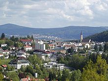
Freyung is the district town of the Freyung-Grafenau district in the administrative district of Lower Bavaria . The city is located in the border triangle of the Bavarian Forest, close to the border with the Czech Republic and Austria .
geography
Geographical location
The district town of Freyung is located in the southeast of the Bavarian Forest on the banks of the Saußbach , which later forms the Wolfsteiner Ohe . The Bavarian Forest National Park is located north of Freyung . Freyung is located 33 km north of Passau , 17 km from the border with the Czech Republic , 18 km from Grafenau and 27 km from the border with Austria .
climate
| Freyung (Bavarian Forest) | ||||||||||||||||||||||||||||||||||||||||||||||||
|---|---|---|---|---|---|---|---|---|---|---|---|---|---|---|---|---|---|---|---|---|---|---|---|---|---|---|---|---|---|---|---|---|---|---|---|---|---|---|---|---|---|---|---|---|---|---|---|---|
| Climate diagram | ||||||||||||||||||||||||||||||||||||||||||||||||
| ||||||||||||||||||||||||||||||||||||||||||||||||
|
Average monthly temperatures for Freyung (Bavarian Forest)
Source:
|
|||||||||||||||||||||||||||||||||||||||||||||||||||||||||||||||||||||||||||||||||||||||||||||||||||||||||
history
From the first documentary mention to the 19th century
The first settlements from the 13th century in the area of today's city of Freyung are known; the inhabitants settled in a clearing village near the old Wolfstein Castle , which Bishop Wolfger von Erla had built around 1200 . Before that, Emperor Heinrich VI. ceded the land to some Passau bishops in 1193. At that time, Freyung was not yet a place name, but referred to an area in which the settlers were granted an exemption, i.e. an exemption from taxes. In 1301 this place was first mentioned in a document as Purchstol zu Wolferstein and a forest .
Already in 1354 the neighboring town of Kreuzberg , which was founded at the beginning of the 14th century, received market rights , which were transferred to Freyung in 1523. When a parish church was built in Freyung in 1380 , Kreuzberg had long been a well-known place of pilgrimage . Today's Kreuzberg parish church and the town's first school were first mentioned around 1500. In the Middle Ages , the two villages were hit twice by the plague , but this did not harm the popularity of the pilgrimage site.
When the Principality of Passau was dissolved in 1803 with the main Imperial Deputation, Freyung first fell to the Austrian Duchy of Salzburg and two years later came to the Kingdom of Bavaria with the Peace of Pressburg . In 1811 there were 535 inhabitants. In a devastating city fire in 1872, 39 of the 70 or so houses were destroyed.
20th century and more recent
On December 3, 1953 Freyung was raised to the city. After the incorporation of Ort Freyung was from April 1, 1954 to June 30, 1972 district town of the Wolfstein district . After the unification of the district with the Grafenau district , it became the district town of the Freyung-Grafenau district .
In March 2017 Freyung was awarded the contract to host the Bavarian State Horticultural Show 2022. This was postponed to 2023.
Incorporations
On April 1, 1954, the previously independent communities Ahornöd and Ort were incorporated. Since the seat of the district office of the Wolfstein district was in Ort, Freyung became the new district town of this district. Kreuzberg was added on April 1, 1971. On May 1, 1978, parts of the community Kumreut were reclassified to Freyung.
There are 27 districts:
|
Outsourcing
On March 1, 1979, an area with around 500 residents was assigned to the Röhrnbach market.
Population development
Between 1988 and 2018, the city stagnated or grew minimally from 7,158 to 7,166 by 8 inhabitants or 0.1%.
| Population development | ||||||||||||
|---|---|---|---|---|---|---|---|---|---|---|---|---|
| year | 1961 | 1970 | 1987 | 1991 | 1995 | 2005 | 2010 | 2015 | 2017 | |||
| Residents | 6862 | 7282 | 7124 | 7458 | 7409 | 7235 | 6923 | 7194 | 7187 | |||
Religions
At the census on May 25, 1987 Freyung had 7,124 inhabitants, of which 6582 (92.4%) were Roman Catholic , 393 (5.5%) Protestant and 149 inhabitants (2.1%) were of other faith.
politics
City council
The local election on March 15, 2020 resulted in the following distribution of votes:
| List / party | Share of votes |
| Christian Social Union in Bavaria (CSU) | 48.15% |
| Citizens' Community City and Country (BGStuL) | 20.57% |
| Ecological Democratic Party (ödp) | 10.81% |
| Non-partisan voters Freyung-Kreuzberg (ÜWFK) | 9.96% |
| Young Voters Union (JWU) | 10.52% |
- Distribution of seats
| CSU | SPD | BGStuL | ödp | ÜWFK | FDP | JWU | total | |
| 2008 | 10 | 1 | 4th | 2 | 1 | 1 | 1 | 20th |
| 2014 | 10 | - | 4th | 2 | 2 | - | 2 | 20th |
| 2020 | 10 | - | 4th | 2 | 2 | - | 2 | 20th |
mayor
- 1946–1952: Josef Haas
- 1952–1956: Ludwig Heydn
- 1956–1972: Josef Lang
- 1972–1978: Otto Fink ( SPD )
- 1978–2002: Fritz Wimmer ( CSU )
- 2002–2008: Peter Kaspar (Citizens' Community City and Country (BGStuL))
- since 2008: Olaf Heinrich ( CSU ), since October 2013 also district assembly president
Currently the city tip consists of
- First Mayor Olaf Heinrich, CSU (2008: 62.74% of the valid votes in the first ballot, 2014: 94.53%, 2020: 94.82%)
- Second Mayor Heinz Lang, GREEN, elected on the list of the CSU
- Third Mayor Christoph Endl, CSU
- further deputy mayor, Josef Gais, CSU
MPs
coat of arms
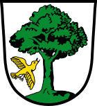
| Blazon : "In silver on green ground, a green tree towards which a golden bird flies from the right." | |
Town twinning
-
 Czech Republic : Vimperk / Winterberg
 -
 Austria : Seewalchen am Attersee
Culture and sights
Museums
- Wolfstein Castle (with hunting and fishing museum and district gallery ) , Wolfkerstraße 3
- Schramlhaus , local history museum in a four-sided courtyard from the 17th century, with a collection of glass and reverse glass paintings , Abteistraße 8
- Winterberg local history museum in the Bohemian Forest , town square 3
Movie theater
The Cineplex in the Stadtplatzcenter opened in November 2013. It has a total of four cinema halls with 500 seats and 3D technology.
Buildings
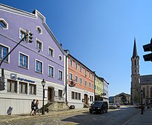
- Catholic parish church Maria Himmelfahrt
- Rectory
- Catholic pilgrimage church St. Anna in Kreuzberg
- Wiesbauerhaus (Stadtplatz 6)
Parks
Sports
- Municipal swimming pool
- Indoor swimming pool
- Holiday park Geyersberg
- sports ground
- 3-way gym
- Solla ice rink
- Single gym of the elementary school at Wolfstein Castle
Regular events
Markets
The Freyung advertising association organizes the SonnYtag in spring and autumn.
Historical festivals
The most famous historical festival, the Freyung Castle Festival, takes place every year on the 1st weekend in September.
Culture days
Culture days are held in Freyung from the end of September to the end of October.
Protected areas
- Buchberger Leite (Wildbachklamm)
Economy and Infrastructure
Industry
- Artificial gemstones are produced in the Freyung carbide plant .
- Plastics processing Freyung (plant of Karl Bachl GmbH & Co. KG )
- Plastics processing Freyung (Aptar Freyung GmbH)
- The art of traditional brewing at Lang Bräu Freyung eG
- Server manufacturer Thomas-Krenn.AG
- Hirschmann Automotive Freyung GmbH
- Max Fuchs AG
- IB / E-Optics
traffic
The city is located at the confluence of the B 533 with the B 12 . These establish the connection to the federal motorway 3 ; the B 12 leads to the border crossing at Philippsreut , where it joins the Czech road I / 4 , which leads via Strakonitz to Prague 180 km away .
Local public transport focuses on RBO buses . A city bus operated by a local bus company is offered for local transport.
In the station Freyung by ending Passau coming Ilztalbahn . This has not been used in regular passenger operation since 1982. After flood damage, it lay fallow from August 2002 to August 2009. It was then supported by the Ilztalbahn GmbH and the Förderverein Ilztalbahn e. V. reactivated and has been used again since September 12, 2010 between Freyung and Waldkirchen and since July 15, 2011 along the entire length. As part of the Danube-Ilz-Moldau leisure traffic project, trains will now operate on Saturdays, Sundays and public holidays in the summer months and on special trips all year round.
Freyung has been offering its citizens a shuttle bus since 2017, which can be ordered using an app and which drives passengers from door to door. A software optimizes the partial routes and calculates the travel costs. The project is initially limited to 3 years. More than ten percent of the residents of Freyung had participated in the project by 2019.
Public facilities
- Freyung district hospital with 260 plan beds
- Land surveying office Freyung
- Freyung District Court
- District Office Freyung-Grafenau
- Health department
- District library
- City library
- Municipal waterworks
- State Veterinary office
- Volunteer firefighter
- Weekly market
- Barracks on Goldenen Steig , location of the reconnaissance battalion 8.
Education and Research
- 4 kindergartens with 190 places
- Forest kindergarten with 20 places
- 2 elementary schools : elementary and middle school (formerly Hauptschule ) with 579 students
- Realschule with 838 students
- Gymnasium with 724 students (as of 2013)
- Montessori School Wolfstein (Elementary School)
- Support center with 53 students
- Catholic Adult Education (KEB)
- Freyung-Grafenau Adult Education Center
- Freyung-Grafenau Music School
- Technology Campus, branch of the Deggendorf University of Applied Sciences with three chairs for geoinformatics , embedded systems and bionics . Commencement of teaching in the winter semester 2009/10.
- Folk Music Academy in Bavaria
- planned: Police Academy
Personalities
Honorary citizen
sons and daughters of the town
- Georg Mayerhofer (March 4, 1894 - December 17, 1966), politician ( Bavarian Party ), Member of the Bundestag .
- Georg Poxleitner (born July 31, 1898 - † May 20, 1964), politician (NSDAP), MdR
- Heinrich List (judge) (March 15, 1915 - July 18, 2018), President of the Federal Fiscal Court a. D.
- Heinrich Schmidhuber (born February 21, 1936), politician (CSU), former member of the state parliament and DFB treasurer
- Peter Krause (* 1957), journalist and voice actor
- Gerhard Drexler (born January 31, 1964), politician (FDP), Member of the Bundestag (May 15 to October 22, 2013)
- Lisa Eder-Held (* 1966), film producer, director and screenwriter
- Sebastian Gruber (born December 4, 1981), politician and district administrator of the Freyung-Grafenau district
- Severin Freund (born May 11, 1988), ski jumper
- Florian Graf (biathlete) (born July 24, 1988), biathlete
- Florian Fesl (born August 1, 1988), popular singer and harmonica player, DSDS candidate 2016
- Julia Eichinger (born December 28, 1992), freestyle skier
- Shkëmb Miftari (born August 1, 1993), football player
- Alexander Kunert (born January 31, 1996), swimming athlete
Web links
Individual evidence
- ↑ "Data 2" sheet, Statistical Report A1200C 202041 Population of the municipalities, districts and administrative districts 1st quarter 2020 (population based on the 2011 census) ( help ).
- ↑ contact person. City administration Freyung, accessed on July 6, 2020 .
- ↑ klima.org
- ↑ Because of Corona: State Garden Show Freyung will not take place until 2023 on June 16, 2020 on br.de, accessed on July 11, 2020
- ^ Wilhelm Volkert (ed.): Handbook of Bavarian offices, communities and courts 1799–1980 . CH Beck, Munich 1983, ISBN 3-406-09669-7 , p. 595 .
- ↑ a b Federal Statistical Office (ed.): Historical municipality register for the Federal Republic of Germany. Name, border and key number changes in municipalities, counties and administrative districts from May 27, 1970 to December 31, 1982 . W. Kohlhammer, Stuttgart / Mainz 1983, ISBN 3-17-003263-1 , p. 628 .
- ↑ bayerische-landesbibliothek-online.de
- ^ Election information from the PNP
- ^ Website Freyung - City Councils
- ↑ PNP election information , accessed on June 7, 2020
- ^ Entry on Freyung's coat of arms in the database of the House of Bavarian History
- ↑ Cineplex in the Bavarian Forest. (PDF) Retrieved May 26, 2016 .
- ↑ Waiting for the on-demand service. Bayerische Staatszeitung , September 7, 2018, accessed on August 6, 2019 .
- ↑ How can you stay mobile in the country without a car? July 4, 2019, accessed July 18, 2019 .
- ↑ Kliniken Am Goldenen Steig gGmbH ::: Home. Retrieved March 27, 2020 .
- ↑ Home - Volksmusikakademie Bayern. Retrieved June 16, 2019 .
- ↑ Andreas Reichelt: Further negotiations necessary. In: Tele Regional Passau 1 (TRP1). Retrieved January 19, 2019 (German).
- ^ Members of the 17th German Bundestag. (PDF) Retrieved May 28, 2016 .


