Fuldaaue (Kassel)
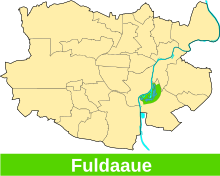
The Fuldaaue is a local recreation area in the south-eastern part of the city of Kassel . It was laid out in the late 1970s for the Federal Horticultural Show in 1981 as an inner-city park on the eastern bank of the Fulda . That is why the area is popularly known as Buga .
Geographical location
The Fuldaaue is located in the Waldau district . It runs in the north from the eastern Fuldaufer at the level of the swimming pool bridge along a footpath to the east to the confluence with the Waldauer footpath . This forms the eastern border of the site. In the south the area is bounded by Damaschkestrasse . In the west, the eastern bank of the Fulda, including the so-called extended regatta course, represents the boundary. The Fuldaaue is connected to the Karlsaue by two pedestrian bridges over the Fulda . There is an artificially created quarry pond , popularly known as the Buga Lake .
natural reserve
The entire area of the Fuldaaue is part of the landscape protection area "Stadt Kassel", which also includes the Karlsaue and the Dönche . The northern part of Lake Buga is also a designated nature reserve with the purpose of securing a breeding, resting and wintering area for numerous water bird species, some of which are endangered
use
The BUGA lake, which is in the center of the Fuldaaue, has several beaches and is used as a bathing lake in summer . The BUGA lake was created when gravel was dug in the Fulda floodplains in the 1960s and the pit subsequently filled with groundwater. The surrounding facilities and beaches were completed in 1980. The lake is 138 m above sea level. NN has an area of 33.7 ha, a maximum depth of 6.78 m and an average depth of 3.35 m. In the western part of the Fuldaaue there is a larger playground , some of which is designed as a water playground. The other parts of the green area are often used for barbecues or sports. The Fuldaaue fulfills the natural purpose of flood protection as a floodplain despite human interference (parking lots, boathouses, camping sites, etc.) . Since the Fuldaaue is a partly almost original landscape, most residents or users such as z. B. the local fishing club or the Kassel drainage company to keep the floodplain in its original state and to promote renaturation in order to secure the habitat for rare and endangered flora and fauna.
Literary mention
Jamal Tuschick wrote about the Fuldaaue:
“During a federal horticultural show, an area on the Fulda was opened up that had served children from Bettenghausen and Waldau as the Wild West. Where a branch of the Fulda cuts a peninsula out of the Waldauer Ufer, there was a nudist zone, I think it was also a disabled sports facility. "
Web links
- Measured values and bathing water profile of Lake Buga - Hessian State Office for Nature Conservation, Environment and Geology (HLNUG)
Individual evidence
- ↑ Fuldaauen-Ordinance , City of Kassel - The Magistrate -
- ^ Ordinance on the nature reserve "City of Kassel" of August 16, 1995 . In: Higher nature conservation authority (ed.): State gazette for the state of Hesse. 1995 No. 37 , p. 3006 , point 962 ( online at the information system of the Hessian state parliament [PDF; 8.4 MB ]).
- ↑ Ordinance on the “Fuldaaue” nature reserve of December 14, 1984 . In: Higher nature conservation authority (ed.): State gazette for the state of Hesse. 1984 No. 53 , p. 2673 , item 1334 ( online at the information system of the Hessian state parliament [PDF; 8.7 MB ]).
- ↑ Natura2000 Ordinance on Bird Protection Area 4722-401 Fuldaaue around Kassel , Kassel Regional Council
- ^ Hessian State Office for Nature Conservation, Environment and Geology: BUGA-See
Coordinates: 51 ° 17 ′ 40 ″ N , 9 ° 30 ′ 10 ″ E


