
Funäsdalen
| Funäsdalen | ||||||
|
||||||
| State : | Sweden | |||||
| Province (län): | Jämtland County | |||||
| Historical Province (landskap): | Harjedalen | |||||
| Municipality : | Harjedalen | |||||
| Coordinates : | 62 ° 33 ' N , 12 ° 33' E | |||||
| SCB code : | 7828 | |||||
| Status: | Crime scene | |||||
| Residents : | 956 (December 31, 2015) | |||||
| Area : | 2.57 km² | |||||
| Population density : | 372 inhabitants / km² | |||||
| List of perpetrators in Jämtland County | ||||||

Funäsdalen is a place ( tätort ) in the Swedish province of County of Jämtland and the historical province of Härjedalen . Funäsdalen is about 135 km west of Sveg on the upper reaches of the Ljusnan River in the municipality of Härjedalen and is an important tourist center. In the village is the Härjedalens Mountain Museum ( Härjedalens fjällmuseum) , which documents the life of the Sami , mountain farmers and miners in this region.
traffic
There is a connection to Ljungdalen via the Flatruetvägen pass road .
photos
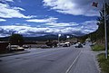
Center of Funäsdalen 1997
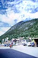
Funäsdalen, Funäsdalsberg


Sons and daughters of the place
- Lars Nelson (* 1985), former cross-country skier
swell
- ↑ a b Statistiska centralbyrån : Land area per Tatort, folkmängd and invånare per square kilometer. Vart femte år 1960 - 2015 (database query)
Web links
Perpetrator: Funäsdalen | Hede | Lillhärdal | Norr-Hede | Sveg | Ulvkälla | Vemdalen | Ytterhogdal
Småorter: Älvros | Bruksvallarna | Glissjöberg | Hedeviken | Herrö | Långå | Linsell | Ljusnedal | Lofsdalen | Nilsvallen | Överberg | Tännäs | Tänndalen | Vemhån | Ytterberg