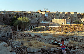
Gökçetoprak
| Gökçetoprak | ||||
|
||||
 Gökçetoprak (1995) |
||||
| Basic data | ||||
|---|---|---|---|---|
| Province (il) : | Nevşehir | |||
| District ( ilçe ) : | Gülşehir | |||
| Coordinates : | 38 ° 40 ′ N , 34 ° 18 ′ E | |||
| Height : | 1093 m | |||
| Residents : | 348 (2014) | |||
| Telephone code : | (+90) 384 | |||
| Postal code : | 50900 | |||
| License plate : | 50 | |||
| Structure and administration (as of 2015) | ||||
| Muhtar : | Mahir Kılınç | |||
Gökçetoprak (formerly Suvasa or Sivasa ) is a village in the Gülşehir district of the Nevşehir province of Turkey . The place is about 35 kilometers southwest of the county seat Gülşehir and 40 kilometers west of the provincial capital Nevşehir . The area belongs to the west of the tufa landscape of historical Cappadocia .
The area of Gökçetoprak / Suvasa belonged to the early 1st millennium BC. To the late Hittite kingdom of Tabal . A semi-sculptural representation of a Greek god can be seen in a rock niche in the village. The heavily weathered sitting figure has a bare upper body, the robe falls over the legs. The German archaeologist and art historian Hans Rott , who discovered the figure in 1906, identified it as Zeus Stratios , the Zeus protecting the army, whose cult was spread throughout Asia Minor . The ancient orientalist Helmut Bossert , who was not familiar with Rott's publication, interpreted the figure as a seated goddess from Greco-Roman in 1958 . Time . In agreement with Rott, he sees this as evidence that the square was a place of worship in ancient times. There was an early Byzantine octagonal church at the site, which in 1906 was still largely upright, but was largely demolished around 1940 to build a school. Nearby is a painted cave church from the 13th century.
To the west of the town is a little-explored underground city . About 1.5 kilometers to the southwest, at the foot of a rocky ridge, stands the Luwian inscription stone from Suvasa .
Web links
Individual evidence
- ^ Turkish Institute for Statistics ( Memento from December 28, 2015 on WebCite ). accessed December 28, 2015
- ↑ Horst Ehringhaus : The end that was a beginning - rock reliefs and rock inscriptions of the Luwian states of Asia Minor from 12th to 8th/7. Century BC Chr. Nünnerich-Asmus, Mainz 2014, ISBN 978-3-943904-67-3 , pp. 40–47.
- ↑ Hans Rott: Kleinasiatische Denkmäler , Leipzig 1908, pp. 253-254 ( full text )
- ↑ Eberhard P. Rossner: Rock monuments in Turkey. Volume 1: The Hittite rock reliefs in Turkey. An archaeological guide. 2nd, expanded edition. Rossner, Munich 1988, ISBN 3-924390-02-9 , p. 129.
- ↑ H. Th. Bossert: The HH inscription from Malkaya In: Orientalia Nova Series Vol. 24 No. 4 (1958) p. 329 note 1
- ^ Hans Rott: Kleinasiatische Denkmäler , Leipzig 1908, pp. 249-253 ( full text ).
- ↑ Rainer Warland : Byzantine settlement traces in the region between Gökçe / Momoasson and Gökçetoprak in Cappadocia (Survey 2009). In: Araştırma Sonuçları Toplantısı 28, Vol. 1, 2011, pp. 249–250 ( full text ).
- ↑ Sivasa Gökçetoprak Yeraltı Şehri ( Memento from July 14, 2014 in the Internet Archive ).


