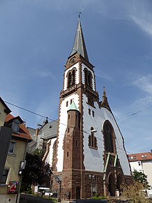
Gablenberg
|
Gablenberg district of Stuttgart |
|
|---|---|
| Coordinates | 48 ° 46 '47 " N , 9 ° 12' 24" E |
| surface | 1.31 km² |
| Residents | 10,756 (May 31, 2020) |
| Population density | 8211 inhabitants / km² |
| Post Code | 70186 |
| prefix | 0711 |
| Borough | Stuttgart-East |
| Source: Data Compass Stuttgart (PDF; 4.15 MB) | |
Gablenberg is a district of Stuttgart and is located 2–3 km southeast of the city center, where the area to the Frauenkopf begins to rise. Gablenberg is a medieval settlement core , originally separated from Stuttgart and Cannstatt , and today belongs to the downtown district of Stuttgart-Ost , to which u. a. also include the historic settlements of Gaisburg (am Neckar) and Berg as well as the more recent residential areas Uhlandshöhe , Ostheim , Stöckach and the Buchwaldsiedlung . These settlements grew together to form a more or less closed area from the end of the 19th century and were finally combined with the Gänsheide settlement to form the Stuttgart-Ost district within the district of the same name, which at the time only included the Frauenkopf district.
Gablenberg was never an independent community - such as the neighboring Gaisburg on the Neckar - although it is over 700 years old. It was an extension of the 12th century town of Berg , was first mentioned in 1275 and administered by the duke's bailiffs. In 1836 the areas were administratively subordinated to the growing city of Stuttgart. In 1956, the towns of Berg, Gablenberg, Gaisburg and Ostheim, which had meanwhile grown together, were administratively united to form the Stuttgart-East district. When the districts were redistributed within the districts in 2001, the current district structure of the Stuttgart-East district was created and the historical names were reactivated as district names.
Building density and facilities
While the central locations are densely built up, the east (towards Raichberg) and the south (towards Fuchsrain and Frauenkopf) are much more loosely built.
In the green belt near the Raichberg there are several sports fields and the Waldheim, and on the wooded hill of the Raichberg (halfway to Wangen ) is the 93 m high Stuttgart police radio tower . It is less than half the height of the telecommunications tower and the television tower , but it contributes significantly to the local cityscape.
Public institutions include a .:
- Evangelical Petruskirche Gablenberg (built 1902)
- Catholic Church of St. Brother Klaus (built in 1969)
- Sports club Gablenberg
- Sports and cultural community Stuttgart-Gablenberg 1884
- Museo, the district museum in the old school
Schools:
- Evangelical Heidehof High School (Gänsheide)
- Raichberg secondary school
- Wagenburg-Gymnasium (Gänsheide, towards Uhlandshöhe)
- Primary and secondary school with Gablenberg Werkrealschule
- Fuchsrainschule (primary school)
Web links
Individual evidence
- ↑ Evangelisches Heidehof-Gymnasium - Welcome! In: heidehofgymnasium.de , accessed on March 23, 2018
- ^ Raichberg Realschule Stuttgart - Realschule in the east of Stuttgart! In: raichberg-realschule-stuttgart.de , accessed on March 23, 2018
- ^ Wagenburggymnasium - Start In: .wagenburg-gymnasium.de , accessed on March 23, 2018
- ↑ Grund- und Werkrealschule Gablenberg In: raichberg-realschule-stuttgart.de , accessed on March 23, 2018
- ↑ Fuchsrainschule In: fuchsrainschule.de , accessed on March 23, 2018


