Glödnitz
|
Glödnitz
|
||
|---|---|---|
| coat of arms | Austria map | |
|
|
||
| Basic data | ||
| Country: | Austria | |
| State : | Carinthia | |
| Political District : | Sankt Veit an der Glan | |
| License plate : | SV | |
| Surface: | 74.7 km² | |
| Coordinates : | 46 ° 52 ' N , 14 ° 7' E | |
| Height : | 748 m above sea level A. | |
| Residents : | 809 (January 1, 2020) | |
| Population density : | 11 inhabitants per km² | |
| Postal code : | 9346 | |
| Area code : | 0 42 65 | |
| Community code : | 2 05 06 | |
| NUTS region | AT213 | |
| Address of the municipal administration: |
Glödnitz 125 9346 Glödnitz |
|
| Website: | ||
| politics | ||
| Mayor : | Johann Fugger ( ÖVP ) | |
|
Municipal Council : ( 2015 ) (11 members) |
||
| Location of Glödnitz in the district of Sankt Veit an der Glan | ||
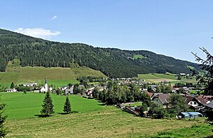
 Glödnitz, west view |
||
| Source: Municipal data from Statistics Austria | ||
Glödnitz is a municipality with 809 inhabitants (as of January 1, 2020) in the Sankt Veit an der Glan district in Carinthia .
geography
The Glödnitztal is a side valley of the Gurktal in the northwest of the Gurktal Alps . The Flattnitz forms a transition into the upper Murtal . Glödnitz borders on Styria and the neighboring communities of Metnitz , Weitensfeld im Gurktal , Deutsch-Griffen and Albeck .
The nature reserves Türkenmoos and Flattnitzbach-Hochmoor are located in the municipality of Glödnitz .
Community structure
The only cadastral community is Glödnitz. The municipality includes the following 19 localities (population in brackets as of January 1, 2020):
- Altenmarkt (126)
- Bach (15)
- Brenitz (41)
- Eden (19)
- Flattnitz (80)
- Glödnitz (321)
- Grai (12)
- Hohenwurz (0)
- Persistent (4)
- Kleinglödnitz (7)
- Lasa (31)
- Lassenberg (29)
- Moss (14)
- Rain (4)
- Downside (8)
- Peat (22)
- Tschröschen (9)
- Weissberg (28)
- Bevelled angles (39)
history
In Roman times an important traffic route ran through the Glödnitztal, and post stations were set up in Beliandrum (probably Altenmarkt) and Tarnasici ( Flattnitz ). The first written mention of the place comes from the year 898 (as Glodati ). According to tradition, the parish church of Glödnitz is traced back to a foundation by Saint Hemma von Gurk ; It is certain that the diocese of Gurk had extensive rulership rights in today's municipality and had a round church with a hospice built on the Flattnitz.
Due to the favorable climatic conditions in the High Middle Ages, the area was more densely populated than it is today, but until the 19th century there were only a few small farms and châteaux .
In 1848 the peasants were liberated in the wake of the bourgeois revolution, and the local community of Glödnitz was established two years later. In the first election, the landlord Franz Gasser became mayor. From the 1920s onwards, tourism was also turned, which today plays an economically important role in Glödnitz. Between 1973 and 1991 the community area belonged to the newly formed large community of Weitensfeld-Flattnitz , but Glödnitz became independent again after a referendum in 1991.
Culture and sights
population
According to the 2001 census, Glödnitz has 1004 inhabitants, of which 97.8% are Austrian and 1.3 German citizens. 90.8% profess to the Roman Catholic and 3.1% to the Protestant Church, 4.7% are without religious belief.
Economy and Infrastructure
The economy is traditionally characterized by agriculture and, above all, forestry. Furthermore, tourism also plays a role to a certain extent, especially winter tourism on the Flattnitz .
As a member community of Kärntner Holzstrasse , Glödnitz has a modern biomass heating system as a showcase project that supplies many households with district heating. Wood chips prepared from residual wood are burned to generate heat.
The community was developed mainly through the Gurktalbahn (from 1898) and connected to the southern railway. In April 1969, the operation of the narrow-gauge railway was stopped and then the line in the area of the community was removed.
politics
Municipal council
The municipal council consists of 11 members and has been composed as follows since the 2015 municipal council election :
The directly elected mayor is Johann Fugger (ÖVP).
coat of arms
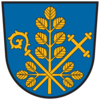
The coat of arms of Glödnitz shows a bishop's staff and a cross staff. The former is a symbol of the Gurk bishop and the cross staff is the attribute of John the Baptist , patron of the church and hospice on the Flattnitz. The leafy golden branch refers to the dwarf birch that can be found on the Flattnitz and is therefore a specialty in terms of vegetation.
The official blazon of the coat of arms reads: “In blue gold, crossed at right angles, a bishop's staff and a cross-staff ending in clover leaves, underlaid by a golden branch with right-angled side shoots in the base of the shield, leafed with opposite golden leaves of the dwarf birch (betula nana). "
The coat of arms and flag were awarded to the municipality on September 20, 1994, the flag is blue and yellow with an incorporated coat of arms.
Web links
- Glödnitz community
- 20506 - Glödnitz. Community data, Statistics Austria .
Individual evidence
- ↑ Statistics Austria: Population on January 1st, 2020 by locality (area status on January 1st, 2020) , ( CSV )
- ↑ Office of the Carinthian State Government ( page no longer available , search in web archives ) Info: The link was automatically marked as defective. Please check the link according to the instructions and then remove this notice.
- ↑ Office of the Carinthian Provincial Government ( Memento of the original from October 8, 2016 in the Internet Archive ) Info: The archive link was automatically inserted and not yet checked. Please check the original and archive link according to the instructions and then remove this notice.
- ^ Quoted from Wilhelm Deuer: The Carinthian municipal coat of arms . Verlag des Kärntner Landesarchiv, Klagenfurt 2006, ISBN 3-900531-64-1 , p. 116


