
Graça
| Graça | ||||||
|---|---|---|---|---|---|---|
|
||||||
| Basic data | ||||||
| Region : | Lisboa | |||||
| Sub-region : | Lisbon metropolitan area | |||||
| District : | Lisbon | |||||
| Concelho : | Lisboa | |||||
| Coordinates : | 38 ° 43 ′ N , 9 ° 8 ′ W | |||||
| Residents: | 5409 (as of June 30, 2011) | |||||
| Surface: | 35 ha (as of January 1, 2010) | |||||
| Population density : | 15,454 inhabitants per km² | |||||
| Postal code : | 1170-196 | |||||


Graça is a district and a former Portuguese municipality ( freguesia ) in the 1st Bairro of the capital Lisbon , located on a hill a little northeast of the Castelo de São Jorge .
As a result of the restructuring of the Portuguese local government, the area has belonged entirely to the newly created municipality of São Vicente since the local elections in 2013 .
Until the community reform, Graça was surrounded by the neighboring communities of Anjos , Penha de França, Santa Engrácia, São Vicente de Fora and Santiago. Last 5409 inhabitants lived in the 0.35 km² large community (as of June 30, 2011).

Monastery garden in the Largo of Graça
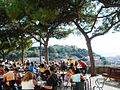
Miradouro Sophia de Mello Breyner Andresen


Individual evidence
- ↑ www.ine.pt - indicator resident population by place of residence and sex; Decennial in the database of the Instituto Nacional de Estatística
- ↑ Overview of code assignments from Freguesias on epp.eurostat.ec.europa.eu