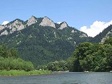
Border between Poland and Slovakia

The border between Poland and Slovakia is 541.1 km in length, 105 km of which are river borders.
course
The border runs generally in a west-east direction and begins at the border triangle Poland-Slovakia- Czech Republic near Čierne / Jaworzynka in the West Beskids and first separates the historical regions of Kysuce and Orava from Silesia . From about the Babia Góra mountain , the border divides the historical Orava region into Polish and Slovak parts. After the section through the Orava basin, past the Orava reservoir , the border first reaches the foothills, then the main ridge of the Tatras , which are the highest border sections for both Poland and Slovakia, with heights of up to 2499 m on Mount Rysy . The border then runs through the historical Spiš landscape , then through the Dunajec Gorge in the Pienines and after another mountain section on the Poprad River between Piwniczna and Muszyna . The eastern section runs along the main ridge of the Lower Beskids through the Dujava Pass , Duklapass , Čertižnépass and Lupkówpass into the Forest Carpathians (PL: Bieszczady , SK: Bukovské vrchy ), where the border at the border triangle Poland-Slovakia-Ukraine ends below the Kremenez mountain .
The neighboring administrative units are the Silesian , Lesser Poland and Subcarpathian Voivodeships in Poland and the Žilinský kraj and Prešovský kraj in Slovakia.
history
The border as such has existed in large parts since the Middle Ages , when it separated the Kingdom of Poland from the Kingdom of Hungary for centuries . In the Austro-Hungarian Dual Monarchy , it ran between the Austrian crown lands of Austro-Silesia and Galicia to the north and the Kingdom of Hungary to the south of the border line.
After the breakup of Austria-Hungary , this border was the subject of international conflicts between Poland and Czechoslovakia , especially in the areas of Orava and Spiš. These could only be settled in 1958 with a treaty between the People's Republic of Poland and Czechoslovakia.
Border crossings
See Slovak border crossings to neighboring countries # Poland
Individual evidence
- ↑ Štatistické údaje o štátnych hraniciach (Slovak), Ministerstvo vnútra Slovenskej republiky, accessed on April 28, 2019


