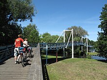
Havel cycle path
| Havel cycle path | |
|---|---|

|
|
| overall length | 394 km |
| location |
|
| Starting point | Source of the Havel near Ankershagen |
| Target point | Havel estuary into the Elbe near Gnevsdorf |
| Website URL | http://www.havelradweg.de |
The Havel cycle path , even Havel bike trail is a Opened on 8 May 2009 Radfernweg along the Havel by the federal states of Mecklenburg-Vorpommern , Brandenburg , Berlin and Saxony-Anhalt . Its length is 371 kilometers. The cycle path begins at the Havel spring 6 kilometers south of Ankershagen and ends in Gnevsdorf at the mouth of the Havel into the Elbe . The path is signposted with a square, dark blue sign with an orange bicycle and a light blue, curved band and the two-line name “HavelRADWEG” in white.
From Ankershagen to Berlin-Spandau, the Havel cycle path runs on the same route as the Berlin – Copenhagen cycle path .
Stages
The cycle path is roughly divided into 6 stages:
1st stage: Ankershagen - Fürstenberg / Havel (73 kilometers):
- From the source of the Havel, head south and cross the Müritz National Park . South of Wesenberg , the cycle path turns east to the stage destination.
2nd stage: Fürstenberg (Havel) - Oranienburg (75 kilometers):
- Shortly after Fürstenberg (Havel), the cycle path bends south again and reaches the stage destination Oranienburg via Zehdenick .
3rd stage: Oranienburg - Potsdam (66 kilometers):
- In a southerly direction, the cycle path crosses the Berlin district of Spandau . Here the cycle path runs along a long chain of large lakes until it finally reaches the stage destination in Potsdam.

4th stage: Potsdam - Brandenburg an der Havel (58 kilometers):
- After Potsdam the cycle path turns west again and reaches the stage destination Brandenburg an der Havel via Werder .
5th stage: Brandenburg - Rathenow (55 kilometers):
- Shortly after Brandenburg, the cycle path turns again and now runs north to the stage destination in Rathenow. In the Kirchmöser district of Brandenburg , the Elbe-Havel cycle path branches off towards Magdeburg.
6th stage: Rathenow - Gnevsdorf (49 kilometers):
- The last stage continues northwards via Havelberg to the mouth of the Havel near Gnevsdorf.
The kilometers indicated on the length of the cycle path differ depending on the source, as alternative routes are possible at different points. For example, the Wannsee can be crossed by ferry or bypassed on the road.
In addition to the Müritz National Park, the path crosses the Stechlin-Ruppiner Land , Uckermark Lakes , Barnim and Westhavelland nature parks as well as the Elbe-Brandenburg river landscape biosphere reserve .
literature
- Havel cycle path - from the Mecklenburg Lake District to the Elbe . Compact spiral 1: 75,000, BVA Bielefelder Verlag, 2011, ISBN 978-3-87073-494-7 .
- Axel von Blomberg , Kai-Uwe Thiessenhusen, Havel-Radweg , green heart , 2016, ISBN 978-3-86636-139-3
- Cycle touring and hiking map with zig-zag folding Havel cycle path. with booklet, Verlag Dr. Andreas Barthel, 2018, ISBN 978-3-89591-172-9 .
Web links
- havelradweg.de
- Havel cycle path at the radreise-wiki
- Route on auf-nach-mv.de or radeln-in-brandenburg.de
Individual evidence
- ↑ Havel Cycle Path ( Memento of the original from November 16, 2012 in the Internet Archive ) Info: The archive link was inserted automatically and has not yet been checked. Please check the original and archive link according to the instructions and then remove this notice. ADFC tour portal
Coordinates: 52 ° 25 ′ 7.7 " N , 12 ° 53 ′ 41.8" E