Hawaii County
| administration | |
|---|---|
| US state : | Hawaii |
| Administrative headquarters : | Hilo |
| Foundation : | 1905 |
| Demographics | |
| Residents : | 185,079 (2010) |
| Population density : | 17.7 inhabitants / km 2 |
| geography | |
| Total area : | 13,174 km² |
| Water surface : | 2742 km² |
| map | |
| Website : www.hawaii-county.com | |
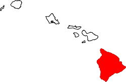
Hawaii County ( English County of Hawaiʻi ) is a county in the state of Hawaii in the United States of America . It is located on the southernmost island of the island chain , the Big Island . The county covers an area of 13,174 square kilometers and has 185,079 residents ( 2010 census ). The county seat and by far the largest and most important city is Hilo .
history
Hawai'i was the home island of Kamehameha I , who in 1795 brought most of the Hawaiian islands under his rule. He gave his kingdom the name of his home island, so today the entire chain of islands is referred to as Hawaii. James Cook , who made the Western world aware of these "Sandwich Islands", was killed on this island. The county’s administrative head is currently Harry Kim.
geography
Hawaii County has a total area of 13,174 square kilometers, including 2,742 square kilometers of water (essentially the coastline, which is counted by the US Census Bureau ). The largest city is Hilo , located on the windward coast, making it one of the wettest cities in the world.
Administrative division
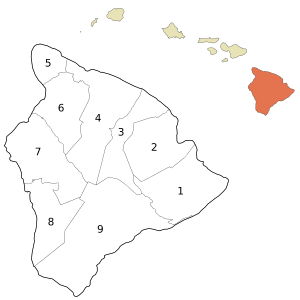
Hawaii County is divided into nine districts. It is based on the six traditional moku (districts), of which three of the most populous (Hilo, Kohala and Kona) have been divided into two districts each in order to reduce discrepancies in terms of comparable population figures.
Districts
The nine districts are listed in the table below, in official order counterclockwise, starting in the southeast.
| No. | District | Area km² |
Population 2000 |
moku | map |
|---|---|---|---|---|---|
| 1 | Puna | 1293.57 | 31335 | Puna | |
| 2 | South Hilo | 1021.44 | 47386 | Hilo | |
| 3 | North Hilo | 959.98 | 1720 | Hilo | |
| 4th | Hāmākua | 1503.49 | 6108 | Hāmākua | |
| 5 | North Kohala | 344.26 | 6038 | Kohala | |
| 6th | South Kohala | 910.95 | 13131 | Kohala | |
| 7th | North Kona | 1266.53 | 28543 | Kona | |
| 8th | South Kona | 868.63 | 8589 | Kona | |
| 9 | Kaʻū | 2388.54 | 5827 | Kaʻū | |
| Hawaii County | 10432.52 | 148677 | 6 moku |
Localities
Settlements
National parks
- Ala Kahakai National Historic Trail
- Hakalau Forest National Wildlife Refuge
- Hawaii Volcanoes National Park
- Kaloko-Honokōhau National Historical Park
- Kona Forest National Wildlife Refuge
- Puʻuhonua o Hōnaunau National Historical Park
- Puʻukoholā Heiau National Historic Site
Individual evidence
- ↑ US Census Bureau Quickfacts: Hawaii (English)
- ↑ Hawaii County: 2000 ( page no longer available , search in web archives ) Info: The link was automatically marked as defective. Please check the link according to the instructions and then remove this notice.
Web links
- Website of the counties (English)
- Volcanoes National Park (English)
Coordinates: 19 ° 35 ′ N , 155 ° 30 ′ W

