
Heinrich-Heine-Allee (Düsseldorf)
| Heinrich-Heine-Allee | |
|---|---|
|
|
|
 |
|
| Heinrich-Heine-Allee (northern section at the Hofgarten ), avenue with a footpath in the central axis | |
| Basic data | |
| place | Dusseldorf |
| District | City center |
| Created | 1806 |
| Newly designed | 1989 |
| Connecting roads | Hofgartenrampe, Maximilian-Weyhe-Allee, Breite Strasse , Kasernenstrasse |
| Cross streets | Ratinger Strasse , Mühlenstrasse, Ludwig-Zimmermann-Strasse, Bolkerstrasse , Elberfelder Strasse, Flinger Strasse , Theodor-Körner-Strasse, Wallstrasse , Grabenstrasse, Trinkausstrasse |
| Places | Heinrich-Heine-Platz, Grabbeplatz |
| Buildings | Breidenbacher Hof , Carsch house , Kaufhof an der Kö , K20 , opera house , Wilhelm Marx house , |
| use | |
| User groups | Pedestrian traffic , bicycle traffic , car traffic , public transport |
| Road design | Hofgarten , central green belt |
| Technical specifications | |
| Street length | 450 m |
The Heinrich-Heine-Allee in Dusseldorf is a busy north-south axis in the center of Düsseldorf. As can be seen from the city map from 1809, various new streets and the moat were laid on the razed and straightened eastern area of the city fortifications around 1805 . The new streets also included a new avenue, Heinrich-Heine-Allee, which was originally expanded into a boulevard in accordance with an imperial decree of December 17, 1811 by Napoleon . The street, about 450 m long and 40 m wide, was first called Boulevard Napoleon . After the end of the Grand Duchy of Berg in 1813, the boulevard became Alleestrasse after several name changes from around the middle of the 19th century . On September 26, 1963, the name Alleestraße was changed to Heinrich Heine , as he was born in the immediately adjacent Bolkerstraße .
location
Heinrich-Heine-Allee runs in a north-south direction on the eastern edge of Düsseldorf's old town and forms the border with the Stadtmitte district . It begins in the north on Ratinger Strasse and ends in the south on Grabenstrasse.
history
Historical development

According to the Peace Treaty of Lunéville , the fortifications of the city were demolished in Düsseldorf from 1801. The former fortress site was to be used to build new roads and parks. These ideas became more concrete from 1802 onwards under the planners Maximilian Friedrich Weyhe , Kaspar Anton Huschberger and Wilhelm Gottlieb Bauer , who designed the Königsallee , among others . Today's Heinrich-Heine-Allee was designed as a wide avenue planted with five rows of trees that should separate the old town from the Hofgarten . The development was planned by Adolph von Vagedes from 1806 onwards in the form of classicist row architecture with group facades. In the same year, the city of Düsseldorf auctioned land for the construction of buildings. The corner lot No. 34 on the avenue, exactly at the place of the little avenue square, was acquired in 1806 by a landlord Wilhelm Breidenbach , who had the Hotel Breidenbacher Hof built on it from 1808 .
From 1811 the street presented itself as a promenade with Parisian flair and was called "Boulevard Napoléon" due to the political situation. In 1813, after the end of the Grand Duchy of Berg , which was under French rule , the avenue was renamed Friedrichsstrasse . However, like the attempt to rename the area between Ratinger Strasse and what was then Friedrichsplatz (today Grabbeplatz ) as Wilhelmstrasse , this name was unpopular with the people of Düsseldorf. For a long time in the 19th century, the avenue planted with linden trees was popularly called “the lime tree avenue” and was accordingly renamed Alleestrasse.
In addition to residential buildings, the city palace of the nobility was built on both sides of the avenue, the Hotel Breidenbacher Hof until 1812 and the Royal Prussian Gymnasium from 1830/31 to 1833 . At that time there was only a narrow lane between the hotel and the grammar school, which led from Alleestraße to Canalstraße (today: the west side of Königsallee) and was converted and widened to Theodor-Körner-Straße after 1900. This street was first listed as Bazarstrasse in Düsseldorf address books in 1876 . At this point in time, the Düsseldorfer Baubank had become the owner of the hotel and in 1876 had also taken over the narrow street from the city and expanded it with pressed asphalt slabs .
Up until the high school was demolished in 1906, hotel operations were affected by the noise from the school, as the school was on the other side of the alley, where the Kaufhof is today. Furthermore, as a result of the re-establishment of the Royal Prussian Art Academy and the flourishing of the Düsseldorf School of Painting, from around 1835 onwards, a large number of galleries were established along Alleestraße and Ratinger Straße, which together formed the first gallery district in the Rhineland. The most prominent gallery was the art exhibition at Alleestraße 42 of the gallery owner Eduard Schulte , in which the high nobility and the upper middle class of the Rhineland went in and out. At the end of the 19th century, the Bismeyer & Kraus art dealer was around the corner in Elberfelder Strasse 5 and later in Bazarstrasse 7-8. The owner of the land on Bazarstrasse (today Theodor-Körner-Strasse) was the Düsseldorfer Baubank .
.jpg)
.jpg)
From around 1870 the noble character of the street changed. The green areas were reduced by laying a tram line through the street. From 1873 to 1875, the city theater was built according to plans by Ernst Giese and served as an opera house from 1920 . This was followed in 1882 by the inauguration of the Städtische Kunsthalle, also designed by Giese, on today's forecourt of the K20 Museum with the main side facing the avenue, which was somewhat damaged during the war and demolished in the early 1960s. Here, among other things, the exhibitions of the Art Association for the Rhineland and Westphalia and after the First World War (Hindenburgwall 11a) the exhibitions of the Young Rhineland , the Blue Rider and the Bridge .
In the 1920s, Johanna Ey, who became famous as "Mother Ey", had a café and exhibition space on the street that was now known as Hindenburgwall. Her restaurant in house no. 11 Junge Kunst - Frau Ey developed into a focal point of the artist movement Das Junge Rheinland .
The classicist building of the “ Royal Prussian High School ” from 1830 gave way in 1906 to the Tietz department store (today Galeria Kaufhof an der Kö ), built by Joseph Maria Olbrich in 1907–1909 . Another department store was built opposite the Carsch House in 1911.
Towards the end of the 19th century in the Wilhelmine phase of the Empire, three monuments to important people in the Prussian era were erected on Alleestraße. These were on with their inauguration
- October 18, 1896, the equestrian monument of Kaiser Wilhelm I in the central axis in front of the Kunstpalast on Friedrichsplatz,
- May 10, 1899, the Bismarck monument in the junction of communication street (eastern end of Bolkerstraße ) / Elberfelderstraße and on
- November 27, 1901, the Moltke monument on Alleeplatz, the southern end of what was then Alleestraße in front of Grabenstraße.
During the Second World War , the monuments were dismantled and stored. After the end of the war, the monuments were no longer erected on Alleestraße, but on Martin-Luther-Platz. From the Moltke monument, which was damaged in the war, only the small group of figures “blacksmith with boy” could be found from the base area, so that only this could be put up again.
In the area of Alleeplatz, which was at the southern end of Alleestraße in front of Grabenstraße, the first high-rise office building in the city, the Wilhelm-Marx-Haus , was finally built in 1924 near the Moltke monument . Until the destruction of World War II, the street presented itself as a modern and bustling city boulevard. Little has been preserved of the former splendor, including the opera house, which was extensively rebuilt between 1954 and 1956, the former Tietz department store (today's Kaufhof), the Carsch-Haus (new building reusing the historical facade 1979–1984), the Ratinger Tor , the Wilhelm- Marx House and a building in the northern area. The facade of the building of the former Reichsbank headquarters in Düsseldorf was integrated into the complex of the K20 Museum .
Designations

Heinrich-Heine-Allee, laid out in 1807, has had many names in its almost 200-year history. The later names reflect the numerous changes in power in Düsseldorf: "Königsstraße", "Boulevard Napoleon" (1811–1813), "Friedrichstraße", "Lindenallee", "Alleestraße", "Hindenburgwall" (from 1915 after Paul von Hindenburg ) In 1949 again "Alleestraße" and finally in 1963 after Heinrich Heine , the most prominent son of the city. This renaming to Heinrich-Heine-Allee took place on September 14-16, 1963 as part of the 675th anniversary celebrations for the city elevation. At the same time, the area between the end of Flinger Strasse and Wilhelm-Marx-Haus, laterally bounded by Carsch-Haus and the eastern part of Heinrich-Heine Allee, was renamed "Heinrich-Heine-Platz".
Today's appearance
Heinrich-Heine-Allee presents itself again today as an avenue street with wide sidewalks and a green strip in the middle. The tram has given way to an underground light rail line , but the heavy traffic makes the street uncomfortable for pedestrians. In the north-eastern part the street borders directly on the Hofgarten, to the south of it lies the opera house, the block of houses of the Düsseldorf industrial club , the modern multi-storey car park with the Kaufhof on the Kö and the new building of the upscale Breidenbacher Hof hotel, which opened in May 2008 . On the western side of the street there is a branch of the Deutsche Apotheker- und Ärztebank , the remarkable Ziem house by Bernhard Pfau (1930), the police station in the old town and the stylish Zurich house on the corner of Grabbeplatz, built in concrete in 1954 by architects Heinrich Rosskotten -Glass architecture designed building of the former « Zurich Insurance », which however was demolished in autumn 2009. The almost windowless, black facade of the K20 Museum (architects: Dissing + Weitling arkitektfirma A / S in Copenhagen , BDA Prize 1990) of the North Rhine-Westphalia Art Collection takes up around 80 m on the west side .
The underground station Heinrich-Heine-Allee is located between the Wilhelm-Marx-Haus and the opera house , one of the most important transfer stations for local public transport , which was built in 1979. On a pedestrian level between the street and the train station, the adjacent streets and department stores are directly linked. The aboveground redesign of the street in 1989 was highly controversial and discussions in local politics continue to flare up to this day.
In 2012, the bronze statue by Felix Mendelssohn Bartholdy , created in 1901 by Clemens Buscher and removed and destroyed by the National Socialists in 1936, was faithfully re-erected on Heinrich-Heine-Allee next to the Deutsche Oper am Rhein.
outlook
The redesign of Düsseldorf City through the subway construction of the Wehrhahn Line with the elimination of the above-ground tracks for the tram, which were no longer needed from the end of 2016, will affect the southern part of Heinrich-Heine-Allee from Ratinger Road that will still lead to changes.

Alleestraße in a northerly direction with the Kaiser Wilhelm monument (before 1904)

Alleestraße in the early 20th century
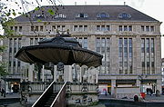
Carsch house with music pavilion

“Kaufhof an der Kö” between Königsallee and Heinrich-Heine-Allee

Heinrich-Heine-Allee in a northerly direction

Felix Mendelssohn Bartholdy Monument in 2012


_(1).jpg)
See also
literature
- Sonja Schürmann: Dumont Art Guide Düsseldorf . DuMont Buchverlag Cologne, 2nd edition 1989
- Düsseldorf through the ages . Reprint of edition v. 1925, Grupello Verlag, Düsseldorf 1994
- Hermann Kleinfeld: Düsseldorf's streets and their names . Grupello Verlag, 1st edition, Düsseldorf 1996
Web links
- Düsseldorf City Archives, Heinrich-Heine-Allee to Wilhelm-Marx-Haus, accessed on December 26, 2007
- Heinrich-Heine-Allee 38 office building with historical pictures
Individual evidence
- ↑ Kraus. In: 3rd year book of the Düsseldorfer Geschichtsgesellschaft. The building history of Düsseldorf . 1888, p. [398] 381.
- ↑ a b c H. Ferber; In: Historical walk through the old city of Düsseldorf ; Published by the Düsseldorfer Geschichtsverein; Verlag C. Kraus, 1889, Part II, p. 106.
- ^ In: Address book of the city of Düsseldorf . 1930, p. [976] 160.
- ^ In: Address book of the Lord Mayor's Office in Düsseldorf. II. Evidence . 1876, p. [162] 6.
- ↑ Bazarstrasse: 1876 manufactured in asphalt by the Düsseldorfer Baubank from pressed asphalt slabs and adopted by the city , in a report on the status and administration of the city's community affairs for the period from April 1, 1884 to March 31, 1885. General affairs . XII. Construction management. P. 137
- ^ In: Address book for the city of Düsseldorf and the mayor's offices. 1st part, H. Higher educational institutions . 1906, p. [77] 39.
- ^ Bettina Baumgärtel: The Düsseldorf School of Painting and its international charisma . In: Bettina Baumgärtel (Hrsg.): The Düsseldorf School of Painting and its International Radiation 1819–1918 , Volume 1, p. 39, Michael Imhof Verlag, Petersberg 2011, ISBN 978-3-86568-702-9
- ^ Bazarstrasse between Allee- and Canalstrasse , in the address book of the city of Düsseldorf, for the year 1898
- ↑ Article Johanna Ey from J. Zigan (2005) in the portal geschichtswerkstatt-duesseldorf.de , accessed on December 23, 2012
- ↑ Hindenburgwall 11: Ey, Joh., Painting exhibition; Hindenburgwall 11 a, E. Stadt Düsseldorf, Kunsthalle , in Düsseldorfer address book 1924, II. Streets and Houses, p. 140
- ^ In: Report on the status and the administration of the community affairs of the city of Düsseldorf. April 1, 1888 to March 31, 1889 . S. [5] -.
- ↑ Emil Schröder. In: Festschrift for the unveiling of the monument to Prince Bismarck . 1899, Bagel, p. [15] 7.
- ^ In: Address book 1909 for the city of Düsseldorf and the mayor's offices . 1909, p. [773] 93.
- ^ In: Address book for the city of Düsseldorf and the mayor's offices. Third part . 1909, p. [732] 52.
- ↑ Renaming of Alleestrasse in Hindenburgwall , in Rhein und Düssel (No. 42), from October 16, 1915
- ^ In: Administrative report of the state capital Düsseldorf, Jan. 1, 1963–31. Dec 1964 . Below: City Chronicle . S. [10] 6. Online version
Coordinates: 51 ° 13 ′ 41 ″ N , 6 ° 46 ′ 37 ″ E