
Hermaringen
| coat of arms | Germany map | |
|---|---|---|

|
Coordinates: 48 ° 36 ' N , 10 ° 16' E |
|
| Basic data | ||
| State : | Baden-Württemberg | |
| Administrative region : | Stuttgart | |
| County : | Heidenheim | |
| Height : | 498 m above sea level NHN | |
| Area : | 15.25 km 2 | |
| Residents: | 2173 (December 31, 2018) | |
| Population density : | 142 inhabitants per km 2 | |
| Postcodes : | 89568, 89537 | |
| Area code : | 07322 | |
| License plate : | HDH | |
| Community key : | 08 1 35 021 | |
| Address of the municipal administration: |
Karlstrasse 12 89568 Hermaringen |
|
| Website : | ||
| Mayor : | Jürgen Mailänder ( independent ) | |
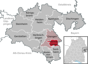
| Location of the community Hermaringen in the district of Heidenheim | ||
  |
||

Hermaringen is a municipality in Baden-Württemberg . It is the smallest independent municipality in the Heidenheim district .
geography
Community structure
The municipality of Hermaringen includes the village of Hermaringen, the Gerschweiler, Hohweiher and the Allewind homestead. Furthermore, the abandoned villages Burg Benzenberg, Burg auf dem Stronberg (commonly known as "Strohmberg"), Güssenburg, Güssenberg, Stettberg, Kapfersfeld and Taublingen are located in the municipality . Hermaringen is on the Brenz .
Division of space

According to data from the State Statistical Office , as of 2014.
history

Early history
The oldest finds of a settlement history in Hermaringen are burial mounds in the Hartwald, which probably come from Celts of the early Hallstatt period. There are very few traces of the Roman period, but urn graves suggest the existence of a manor.
The place name Hermaringen, which is derived from the male name Herimar , was first mentioned around 1150 as Haermeringen . The first documentary mention comes from the year 1216, at that time it belonged to the county of Dillingen . Since the 13th century, the local lords were the casts who built the nearby Güssenburg . After the imperial cities of Ulm , Lauingen and Giengen an der Brenz destroyed it in June 1448, the castle was acquired by Count Ulrich von Württemberg in the same year .
Religions
As in all of Württemberg , the Reformation was introduced in Hermaringen in the 16th century . The place has been evangelical since then . The small Roman Catholic community in the village, which was formed after the Second World War from refugees and displaced persons , receives spiritual care from Giengen an der Brenz in the context of a “pastoral care unit” in the lower Brenz valley .
Population development
The population figures according to the respective territorial status are estimates, census results (¹) or official updates from the State Statistical Office of Baden-Württemberg ( main residences only ).

|
|
politics
mayor
Jürgen Mailänder (non-party) was re-elected on January 10, 2010 with 98.76% of the vote.
Former mayors are Oskar Enslin, Fritz Keck (1948 to 1978) and Kurt Keller (1978 to 2002).
Municipal council
The municipal council in Hermaringen has 12 members. In the local elections on May 26, 2019 , the local council was elected by majority vote. Majority voting takes place if no or only one nomination has been submitted. The applicants with the highest number of votes are then elected. The municipal council consists of the voluntary councilors and the mayor as chairman. The mayor is entitled to vote in the municipal council. The turnout was 69.7% (2014: 61.0%).
coat of arms
The Hermaringer coat of arms shows three six-pointed silver stars in the shield head, the symbol of the casts. In the sign you can see a green linden tree . The municipality colors are green-silver and green-white.
Community partnerships
A partnership with the Saxon community of Claußnitz has existed since 1992 .
Economy and Infrastructure
traffic
Hermaringen is on the federal highway 492 (to Herbrechtingen ). There is a connection to the federal motorway 7 (exit 117). Hermaringen is located on the Brenzbahn ( Aalen - Heidenheim - Ulm ) and belongs to the Heidenheim tariff association. The thoroughfare is after the two kings Württemberg I. Friedrich and Charles I named.
Established businesses
In the industrial area Berger Steig:
- Hauff-Technik GmbH & Co. KG
- Moroff and Baierl GmbH
- Lindel Bau GmbH
- Strobel garden u. Landscaping GmbH
- Klaiber GmbH
In Gersch hamlet is the United Filzfabriken AG .
Educational institutions
With the Rudolf-Magenau-Schule , Hermaringen has its own primary school . Secondary schools can be attended in Giengen and Heidenheim .
Attractions
In addition to a stumbling block , where Georg Elser's birthplace formerly stood, there has been a memorial for the son of the community on Rathausplatz since November 4, 2019, inaugurated by Federal President Frank-Walter Steinmeier .
The ruins of Güssenburg Castle are located on the Schlossberg above the Brenz Valley.

Personalities
Honorary citizen
- Fritz Keck
- Kurt Keller
Born or raised in Hermaringen
- Gerdt von Bassewitz (1878–1923), writer, author of Peterchens Mondfahrt
- Dieter Braun (* 1943), motorcycle racer, two-time world champion
- Georg Elser (1903–1945), cabinet maker, resistance fighter and Hitler assassin, after whom a street in Hermaringen was named in 1984
Associated with Hermaringen
- Rudolf Magenau (1767–1846), Protestant pastor in Hermaringen from 1819 to 1846
Web links
Individual evidence
- ↑ State Statistical Office Baden-Württemberg - Population by nationality and gender on December 31, 2018 (CSV file) ( help on this ).
- ^ The state of Baden-Württemberg. Official description by district and municipality. Volume IV: Stuttgart district, Franconian and East Württemberg regional associations. Kohlhammer, Stuttgart 1980, ISBN 3-17-005708-1 . Pp. 598-600.
- ↑ State Statistical Office, area since 1988 according to actual use for Hermaringen.
- ↑ Hauff-Technik Hermaringen: Hauff-Technik - cable seals, pipe seals, house entries. Retrieved June 9, 2020 .
- ↑ Manufacturer for CNC machines - high-performance machining centers. Accessed June 9, 2020 (German).
- ↑ (no title). Accessed June 9, 2020 (German).
- ^ Hermann Strobel gardening and landscaping in Hermaringen. Retrieved June 9, 2020 .
- ↑ Home. Accessed June 9, 2020 (German).
- ↑ Memorial for Hitler Assassin: Georg Elser's place of birth honors very late , deutschlandfunkkultur.de from October 31, 2019, accessed November 7, 2019
- ↑ Hermaringen - Elser's birthplace on georg-elser-arbeitskreis.de. Retrieved October 25, 2015.
- ↑ Rudolf Magenau's biography on hermaringen.de.
