
Helpful
|
Helmend Helmand |
||
 Kajaki dam on Hilmend |
||
| Data | ||
| location | Afghanistan , Iran | |
| River system | Helpful | |
| Headwaters | Koh-e Paghman 34 ° 38 '41 " N , 68 ° 40' 15" O |
|
| muzzle |
Sistan basin , Hilmend-See Coordinates: 31 ° 0 ′ 0 ″ N , 61 ° 15 ′ 0 ″ E 31 ° 0 ′ 0 ″ N , 61 ° 15 ′ 0 ″ E |
|
| Mouth height |
427 m
|
|
| length | 1125 km | |
| Catchment area | 386,000 km² | |
| Discharge at the Kajakai A Eo gauge : 46,600 km² |
MQ 1947/1960 Mq 1947/1960 |
201 m³ / s 4.3 l / (s km²) |
| Discharge at the Darwesan A Eo gauge : 118,000 km² |
MQ 1956/1960 Mq 1956/1960 |
260 m³ / s 2.2 l / (s km²) |
| Discharge at the Char Burjak A Eo gauge: 136,735 km² |
MQ 1948/1979 Mq 1948/1979 |
183 m³ / s 1.3 l / (s km²) |
| Left tributaries | Tīrī Rūd ( ⊙ ), Arghandāb ( ⊙ ) | |
| Right tributaries | Dard-i-Khudi , Kaj ( ⊙ ), Musa Qala ( ⊙ ) | |
| Reservoirs flowed through | Kajaki dam ( ⊙ ), Bughra dam | |
| Medium-sized cities | Gereschk ( ⊙ ), Laschkar Gah ( ⊙ ) | |
| Small towns | Sangin ( ⊙ ) | |
 Hilmend catchment area |
||
 Bughra Dam |
||
 Changes in the Sistan Basin from 1999 to 2003 |
||
The 1125 km long Hilmend ( Persian هلمند Helmand , also called Hirmand ;هیرمند Hīrmand ) is the longest river in Afghanistan . In ancient times the river was called Etymandros by Arrian , Erymanthus by Polybios and Haetumat in Avesta .
course
Its source is west of Kabul in Koh-e Baba . From there it flows towards the southwest. From the left, the Tīrī Rūd flows into the province of Uruzgan . 50 km downstream it is dammed into a 107 km² lake by the Kajakai dam built in 1952 in the Afghan province of Helmand . The village of Sangin is located about 40 km southwest of the Musa Qala tributary . At Gereschk he leaves the mountains and is crossed by the main Afghan road, the so-called ring road . Immediately south of the provincial capital Laschkar Gah , the Arghandāb flows into the Hilmend from the left. There are still about 400 km to the Iranian border. As an alien river, it flows through the desert, on the right the Dascht-e-Margo - and on the left the Rigestan desert, into the Sistan Basin, which is over 50,000 km² in size and extends from the Afghan province of Nimrus to the Iranian province of Sistan and Balochistan . There it forks and ends, among other things, in the end lake Hamun-e Helmand .
irrigation
The discharge of the Hilmend averages 78 m³ / s. However, it fluctuates very strongly: 2000 m³ / s during floods and 56 m³ / s during drought . About 70% of the farmland downstream from the Kajakai Dam is irrigated through numerous channels dating from the 1960s. About two thirds of the water from the Hilmend is used for this.
| channel | Geocoordinate | Remarks |
|---|---|---|
| Bughra | 31 ° 50 ′ 10 " N , 64 ° 38 ′ 6" E | Discharge 70 m³ / s |
| Darvishan | 31 ° 11 ′ 15 ″ N , 64 ° 12 ′ 12 ″ E | |
| Shamalan | 31 ° 34 ′ 45 " N , 64 ° 20 ′ 58" E |
Political conflict
The runoff at the Iranian border is a conflict between Iran and Afghanistan that lasted more than 100 years, which was not resolved even by the 1973 contractually agreed discharge rate of 26 m³ / s. The average discharge there (in m³ / s) was 70 in 1991, fell below 17 in 1993, rose again to almost 70 in 1997 and was only 1.5 in 2001. Iran made a written complaint to the Secretary General of the United Nations on September 20, 2001 . According to an investigation in July 2000 at the Kajakai dam and at the upstream hydrometric station in the Dihrawud district of Uruzgan province, the dam is said to have been closed. In 2006 the United Nations initiated a joint GEF project.
mysticism
Some theses take the view that the Hilmend is the mythical river Sarasvati from the Vedic scriptures .
Hydrometry
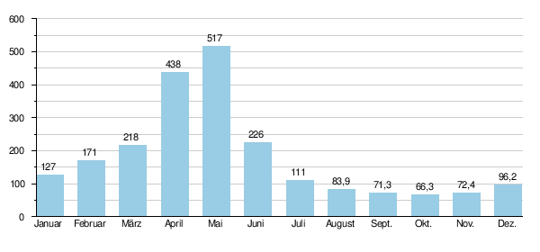
Mean monthly discharge of the Helmand at the Char Burjak gauge
(in m³ / s, 80 km above the state border, 445 km below the Kajakai dam, measured from 1948 to 1979)
Web links
- United Nations Environment Program 2003: Lake Hamoun
- Afghanistan Physical Maps: Southwest (PDF, 1.6 MB)
Individual evidence
- ↑ a b c d briancoad.com Drainage Basins- Sistan
- ↑ UNESCO - Kajakai ( Memento of the original from March 3, 2016 in the Internet Archive ) Info: The archive link has been inserted automatically and has not yet been checked. Please check the original and archive link according to the instructions and then remove this notice.
- ↑ UNESCO - Darwesan ( Memento of the original from March 4, 2016 in the Internet Archive ) Info: The archive link was inserted automatically and has not yet been checked. Please check the original and archive link according to the instructions and then remove this notice.
- ↑ a b Tara Williams-Sether: Streamflow Characteristics of Streams in the Helmand Basin, Afghanistan (PDF 5.31 MB) USGS.
- ↑ While Helmand and Hirmand apply to the river, the province is called Hilmand or Helmand without [r].
- ↑ Martijn Theodoor Houtsma u. a. (Ed.): EJ Brill's first encyclopaedia of Islam. 1913-1936, Volume 2, p. 298
- ↑ a b Regional Rural Economic Regeneration Strategies (RRERS) October 31, 2006: Helmand Province ( Memento of the original from September 21, 2007 in the Internet Archive ) Info: The archive link has been inserted automatically and has not yet been checked. Please check the original and archive link according to the instructions and then remove this notice. (PDF, 76 kB)
- ↑ a b Integrated Water Resources Management for the Sistan Closed Inland Delta, Iran ( page no longer available , search in web archives ) Info: The link was automatically marked as defective. Please check the link according to the instructions and then remove this notice. Annex B - Flow Forecasting (PDF, 1.5 MB) 2006
- ^ Radio Free Europe 2005: Iran / Afghanistan: Still No Resolution For Century-Old Water Dispute
- ↑ NASA's Earth Observatory 2002 From Werland to Wasteland
- ↑ Letter dated September 20, 2001 from the Permanent Representative of the Islamic Republic of Iran to the United Nations (PDF; 96 kB)
- ↑ UNEP Afghanistan: Post-Conflict and Disaster Management Branch ( Memento of the original from October 11, 2007 in the Internet Archive ) Info: The archive link was automatically inserted and has not yet been checked. Please check the original and archive link according to the instructions and then remove this notice.
- ↑ GEF International Waters projects: sistan-project-concept-paper.pdf (670 kB)