Hilsbach
|
Hilsbach
City of Sinsheim
|
|
|---|---|
| Coordinates: 49 ° 11 ′ 40 ″ N , 8 ° 51 ′ 28 ″ E | |
| Height : | 242 m |
| Residents : | 2273 (December 31, 2017) |
| Incorporation : | July 1, 1971 |
| Postal code : | 74889 |
| Area code : | 07260 |
|
Location of Hilsbach in Sinsheim
|
|
|
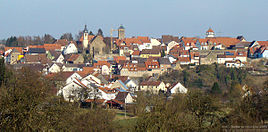
Hilsbach, view from the southwest
|
|
Hilsbach is a formerly independent town in the south of the Rhein-Neckar district in Baden-Württemberg , which has belonged to Sinsheim since 1971 .
geography
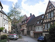
Hilsbach is located in the headwaters of the stream of the same name , a tributary of the Elsenz in the northeastern Kraichgau in the north of Baden-Württemberg about ten kilometers south of Sinsheim . The plateau from the north (Weiler / Steinsberg) drops steeply into the Hilsbach valley; this results in the Hilsbach typical location between upper and lower town, connected with steep stairs and alleys. On two mountain spurs jutting out towards the Hilsbach valley, the office building of the winery and the Michaelskirche were erected as striking buildings. That is why the view of the city from the south from the “tub” opposite the valley on the country road from Elsenz is the face of the city that was often chosen in earlier engravings, paintings and photographs.
history
Hilsbach is mentioned for the first time in 798 in the Lorsch Codex in a deed of donation to the Lorsch Monastery as Hilleresbach . The first settlement was probably in the valley of the Hilsbach (today's lower town ), later a fortress with massive masonry was built on a hill in the area of the upper town . The Counts of Oettingen built a church there in the early 13th century. Around the year 1310 Hilsbach was raised to the rank of town , relocated to the mountain and surrounded by a fortress wall up to 20 meters high. The area enclosed by this city wall was about 250 × 200 meters. Various other families were wealthy in Hilsbach, including the Lords of Gemmingen , the Count Palatine , Bavaria, the Counts of Hohenlohe , the Counts of Katzenelnbogen , the Lords of Venningen and the Teutonic Order .
Hilsbach came from the Counts of Oettingen to the Electoral Palatinate in 1310 together with Steinsberg and Weiler . The lords of Venningen, who had been wealthy in Hilsbach since 1361 and who provided many electoral palatinate castle bailiffs on the nearby Steinsberg, received the Steinsberg, Weiler and the farms of Birkenau and Buchenau as an electoral palatinate fiefdom in 1517. The Electoral Palatinate Bailiwick was then relocated from Steinsberg to Hilsbach and a winery was established there in 1521 . The catchment area of the Hilsbach winery included Elsenz , Kirchardt , Serien , Richen , Schluchtern , Sinsheim , Stebbach , Steinsfurt and Streichenberg .
During the Peasants' War in 1525, under the leader Anton Eisenhut, the winery as well as stately and ecclesiastical goods were plundered by farmers. During the Thirty Years' War the place was plundered and devastated several times. In 1641, a city fire destroyed other buildings. In 1667 the church collapsed due to its disrepair. In the late 17th century, numerous settlers from France and Switzerland were taken in to the slowly recovering town that belonged to the Palatinate Oberamt Mosbach .
In the late 18th century there were plans for the Amtskeller Jung to rebuild an entire village in the district, which is expanding south-east of the city, for reasons of better building options. The plans were not implemented, only the outside of the Junghof goes back to the attempted settlement.
In 1803 Hilsbach came to the newly founded principality of Leiningen , but as early as 1806 Hilsbach came to Baden with the Leiningen rule . In 1808 an administrative office in Leiningen was set up, in 1813 Hilsbach came to the Baden District Office in Eppingen and in 1841 to the District Office in Sinsheim .
Around 1800 the population was around 1000 people in around 160 houses. In 1806 there were still five towers, two of which were gate towers. At that time, the place began to grow beyond the city walls. The upper gate was torn down around 1822. The growth in area was opposed by the emigration and emigration of residents who tried to escape the prevailing poverty elsewhere. In November 1854 alone, 202 Hilsbachers emigrated to the USA. The local Jewish community had set up a synagogue in the Jewish quarter and was numbered with 28 people in 1857, but was dissolved in 1877 due to a lack of believers. Around 1900 Hilsbach had around 1250 inhabitants, including nine Jews. In 1900 the extended Katzbachbahn , the railway line from Odenheim to Hilsbach, was opened.
The place came to this in 1936 when the district of Sinsheim was founded and lost its town charter at the time of the Third Reich . In 1939 there were 1,139 inhabitants, at the end of 1945 there were 1,321. After the Second World War , the population grew to over 1,800 in 1951 due to the influx of refugees and displaced persons into the newly created building areas. In 1956 Hilsbach regained city rights. In 1960 the railway section from Odenheim to Hilsbach was closed. On July 1, 1971, Hilsbach was incorporated into Sinsheim with around 1500 inhabitants at that time.
In 1982 the baroque official cellar was converted into the town hall, and from 1990 to 1999 a comprehensive renovation program was carried out in the center of the town. In 2003 there were 2230 inhabitants.
| Former municipal coat of arms | |
| Blazon : "In a blue-silver awakened shield a blue wave bar." | |
| Justification of the coat of arms: The blue-silver colors symbolize the long ruling Electoral Palatinate, which was enfeoffed in 1214 by Emperor Friedrich II in the dispute between Welfs and Staufers to the Wittelsbacher " Ludwig der Kelheimer ". Hence the connection between the Bavarian, Electoral Palatinate and Hilsbach coats of arms over the blue and white diamonds (Wecken). The "Wittelsbach" lozenges are already contained in the oldest known Hilsbacher seal (according to Franz Gehrig (page 29/30) on documents from 1475 to 1556). The wave bar (brook) turns the coat of arms into the talking coat of arms . A corrugated bar has been documented in the city seal since the 15th century, the Palatinate rhombuses appear in city seals from the 18th century. This dating to the 18th century in the earlier text does not coincide with the result of Franz Gehrig (see above), according to which the diamonds can already be proven on documents from 1475 to 1556. The much earlier evidence of the diamonds in the Hilsbach seal also corresponds to the takeover of the Electoral Palatinate by the Wittelsbachers in the Palatinate-Rudolfine line in the Pavia house contract in 1329. Today's coat of arms was designed by Mrs. Held in 1898. |
Attractions
- The baroque New Official Winery was built in 1732/33. The building served as the Princely Leiningen Rent Office from 1808 and as a schoolhouse after 1840. It has been the town hall since 1982 . The coat of arms on the building is that of German master Clemens August around 1750 and originally comes from a former neighboring building of the Teutonic Order .
- At the guard house with its imposing colonnade, which was built in 1808 and in its current form from 1823, was once the Upper Gate . The building was the customs office and office of the night watchman, later also a police post and local prison.
- Only a tower and a cellar remain from the Electoral Palatinate official cellar from the 16th century. Part of the city wall can also be found in fragments .
- The Protestant Michaelskirche goes back to a Gothic choir tower from the 13th century, after the collapse in 1667 the tower and nave were rebuilt in 1685. In the Michaelskirche there are several historical epitaphs from the 15th and 16th centuries. The church was a simultaneous church from 1705 until 1951 when the new Catholic Church of St. Mary was built . At the Michaelskirche is the old school and rectory , which served as a reformed schoolhouse from the late 16th century and as the residence of the Catholic priest from 1708 to 1843. The Protestant and Catholic (built in 1843) pastoral offices are located at the Marienkirche.
- The Jewish quarter is a historically preserved quarter of the former Jewish community in Hilsbach , where the synagogue was also located in the 19th century. In their place there is now an old farm building. The betting fountain there (horse trough ) was renewed in 2003 as the Hilsbacher Katzenbrunnen .
- The old town hall is a brick building designed by the Hoffenheim architect Dick from 1893 and replaced a previous building at the same location.
- The new schoolhouse was built in 1914 behind the official cellar, which was then used as a school, and from 1925 to 1965 also housed a cooking school in the basement. The building has been used as a residential building since 1981.
- The water tower was built in 1927/29 and is decorated with ceramics in the base area and around the windows of the tower top.
- The old dance linden tree was planted around 1805 in front of the lower gate . The tree was once much taller, but the upper part of its crown was lost after storm damage. Due to the expansion of the village in the 19th and 20th centuries, the tree originally planted on the outskirts is now in the middle of the village.
Personalities
- Friedrich Oswald Sauerbronn (born September 26, 1784 in Hilsbach, † December 4, 1864 in Nova Friburgo ), Protestant pastor who emigrated to Brazil
- Georg von Vogel (1796–1855), administrative officer and member of the state parliament, born in Hilsbach
- Renate Jung (* 1943), German painter and book author, was born in Hilsbach
- Joy Fleming (* 1944; † 2017) lived in Hilsbach since the 1970s and ran a recording studio there.
Individual evidence
- ↑ Minst, Karl Josef [transl.]: Lorscher Codex (Volume 4), Certificate 2602, August 5, 798 - Reg. 2635. In: Heidelberg historical stocks - digital. Heidelberg University Library, p. 181 , accessed on April 10, 2016 .
- ^ City of Sinsheim: Hilsbach. In: sinsheim.de. Retrieved February 9, 2017 .
- ↑ Communications from the Württ. And Bad. State Statistical Office No. 2: Results of the population census on December 31, 1945 in North Baden
- ^ Federal Statistical Office (ed.): Historical municipality directory for the Federal Republic of Germany. Name, border and key number changes in municipalities, counties and administrative districts from May 27, 1970 to December 31, 1982 . W. Kohlhammer, Stuttgart / Mainz 1983, ISBN 3-17-003263-1 , p. 479 .
literature
- Käthe Zimmermann-Ebert: Large district town Sinsheim - around the Steinsberg. Sinsheim 1990
- Franz Gehrig : Hilsbach, chronicle of the highest town in Kraichgau , 1979
- Meinhold Lurz: From the Electoral Palatinate city to the district of Sinsheim. Hilsbach's development over the past 200 years . In: Kraichgau. Contributions to landscape and local research , volume 15, 1997, pp. 201–223


