Hochplett
| Hochplett
(Hochplettspitze)
|
||
|---|---|---|
|
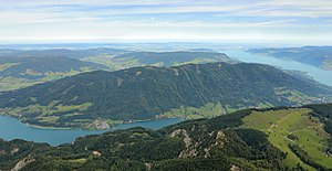
South view of the Hochplett |
||
| height | 1134 m above sea level A. | |
| location | Upper Austria , Austria | |
| Mountains | Mondsee Flysch Mountains , Salzkammergut Mountains | |
| Dominance | 4.3 km → Schafberg | |
| Notch height | 569 m ↓ Oberhofen am Irrsee | |
| Coordinates | 47 ° 49 ′ 19 ″ N , 13 ° 28 ′ 10 ″ E | |
|
|
||
| rock | Lime sandstone , marl ( cement marl series of the flysch zone ) | |
| Age of the rock | approx. 90–70 million years ( Coniacium - Campanium ) | |
The Hochplett is a mountain range of the Mondsee Flysch Mountains in the Upper Austrian Salzkammergut . Its highest point is the 1134 m above sea level. A. high Hochplettspitz .
Location and landscape
The Hochplett is in front of the Schafberg ( 1782 m ) northeast and extends between the southern ends of Mondsee in the west and Attersee in the east. It is separated from the Schafberg massif by the valley of the Seeache near Unterach , which connects Mondsee and Attersee. To the north it extends to the valley basins of Innerschwand and Oberwang , with the lower Wangauer Ache and the Riedlbachtal . Between Riedlbachtal and Attersee, the 715 m high saddle of Streit near Nussdorf connects the Hochplett massif with the massif of Rossmoos ( 1015 m ) to the northeast. The Kulmspitze ( 1095 m ) rises north-west beyond the Wangauer Ache .
The elongated, flat and mid-mountain ridge stretches west-east for 11 kilometers, with foothills from the Mondsee peninsula from Linort to the Parschallenbach am Attersee. Only the footprints are rural cultural landscape, the main part is wooded, forested hill country.
geology
Geologically , the high plateau belongs to the flysch zone of the Alps, and forms the direct southern border of the Northern Limestone Alps with Schafberg and Zimnitz , the Seeachen valley follows the Innsbruck-Salzburg-Amstetten fault system. The massif is formed from the cement marl series ( Coniacium to Campanium , approx. 90–70 million years old), which are sand-lime stones and marlstone . At the foot of the mountain, on the shores of the Mondsee near Brunnfeld and Ort, as well as on the entire north foot, there is an older Reiselsberg Formation and Seisenburg Formation ( Albium to Santonium , approx. 110–80 million years), at Unterach also Rehbreingraben Formation (silicified Gaultflysch, Aptium to Albium, around 110 million years). The cement marl series forms a hollow . The Hochplett ceiling, named after the massif, stretches in the west from the Heuberg near Salzburg to the Krahberg on the east bank of the Attersee. It reaches the greatest width at the Hochplettspitz, and the cement marl series here is 500 m thick.
summit
The most important peaks of the barely indented Hochplett massif are (west-east):
- Hölblingkogel ( 994 m )
- Koppenstein ( 1123 m )
- Hochplettspitze ( 1134 m )
- Great Hollerberg ( 1090 m )
- Hochgupf ( 1071 m )
- Kleiner Hollerberg ( 993 m )
Paths and sights
The mountain is an easy walking and cycling area. In the eastern part there are two small marshy mountain lakes, the Egelsee (nature reserve) and the Ellerwiessee . At the southern foot of the Mondsee lies the lake pile dwelling of the Stone Age Mondsee culture ( UNESCO World Heritage ). A chestnut forest (nature reserve) is located near Unterach .
Web links
Individual evidence
- ↑ Clem Clements, Jonathan de Ferranti, Mark Trengove: The MOUNTAINS AND HILLS of the SALZKAMMERGUT, AUSTRIA: 80 summits with at least 150 m of prominence , November 2011, p. 7.
- ↑ Federal Office for Metrology and Surveying Austria: Hochplettspitz on the Austrian Map online (Austrian map 1: 50,000) .
- ↑ This description follows the cultural landscapes 2.3 and 2.4. of the municipality Unterach in the natural area mapping Upper Austria: Office of the Upper Austrian Provincial Government (Ed.): Landscape survey Unterach am Attersee. Final report. Attnang-Puchheim 2005, PDF on ZOBODAT cf. also the reports Innerschwand , Oberwang , Nußdorf (all pdf ibid.).
- ↑ Dirk van Husen, Hans Egger; Federal Geological Institute (Hrsg.): Geological map of the Republic of Austria . Explanations for sheet 65 Mondsee. Vienna 2014, p. 43 ff (in pdf p. 45 ff).
-
↑ a b c
Hans Egger: On the geology of the flysch zone in the state of Salzburg. In: Jahrbuch d. Geol. Bundes-Anstalt Volume 132, Issue 2 (1989), 3.6. The Hochplett ceiling , p. 392, full article p. 375–395, PDF on ZOBODAT there p. 18; also Fig. 3. Tectonic overview map of the southeast Bavarian and Salzburg flysch zones, p. 384/385, pdf p. 10/11);
Compare Profile section panel 2, Husen, Egger: Explanations 2014, appendix (pdf p. 147). - ↑ Eberhard Fugger already described the semicircular storage on the Mondsee shore: The Upper Austrian pre-Alps between Irrsee and Traunsee. In: Yearbook dkk geol. Reichsanstalt , 1903, Volume 63, Volume 2, p. 305 f ( full article p. 295–350, pdf , opac.geologie.ac.at, p. 11 f).

