
Jonenbach flood retention basin
| Jonenbach flood retention basin | |||||||
|---|---|---|---|---|---|---|---|
 |
|||||||
|
|||||||
|
|||||||
| Coordinates | 677 115 / 236450 | ||||||
| Data on the structure | |||||||
| Construction time: | 2004 to 2007 | ||||||
| Height of the structure crown: | 19.35 meters | ||||||
| Building volume: | 123,000 m³ | ||||||
| Crown length: | 163 meters | ||||||
| Crown width: | 5 meters | ||||||
| Slope slope on the air side : | 1: 3 | ||||||
| Slope slope on the water side : | 1: 3 | ||||||
| Data on the reservoir | |||||||
| Storage space | 392,000 m³ | ||||||
| Catchment area | 21 km² | ||||||
| Particularities: |
Is very close to the village |
||||||

The Jonenbach flood retention basin , also known as the Jonental retention basin , is one of the 21 existing and six planned retention basins in the canton of Zurich in Switzerland . It was built to protect the communities of Affoltern am Albis and Zwillikon from flooding of the 17-kilometer-long Jonenbach . The construction has already prevented two floods in 2007 and 2008. The retention basin above the flood retention dam is a so-called dry basin or green basin and consists largely of forest area. When the water is normal, the stream flows through the dam. During flooding, some of the water is dammed for a short time (usually only hours). This construction project was a joint project of the Office for Waste, Water, Energy and Air, the Civil Engineering Office and other cantonal offices.
Location and geology

The retention basin is located southeast of Affoltern am Albis in the Swiss canton of Zurich , close to the municipal boundary with the neighboring municipalities of Mettmenstetten and Rifferswil . The Jonental is traversed by the Jonenbach from the southeast . Shortly before Affoltern, the valley narrows, so that a dam with relatively little bulk volume could be built here. However, the dam is very close to the village and the next house is less than 50 meters away. The catchment area for the water in the Jonenbach above Affoltern is approximately 21 km².
In geological terms, Affoltern is located in the molasse basin of the Swiss Plateau , which was filled in the course of the Tertiary with the erosion debris of the emerging Alps, whereby the sediments can be divided into different layers of sea molasses and freshwater molasses.
Situation before the construction of the flood retention basin
The Jonenbach had repeatedly caused flooding during floods before the flood retention basin was built . The base fire department had every year the community with sandbags against the flood waters and protect pump out full spilled basements and garages. The floods are caused by heavy rain and by the fact that people take up more and more space and keep the water within narrow limits. However, the flood protection projects presented before 1994 were not approved by the municipality.
In the two strong floods of 1994 and 1999, the municipality found damage of at least 11.4 million francs (approximately 7.5 million euros). This did not include the damage in the settlement and agricultural areas that are not covered by the insurance. It was only after these floods that a project that had already turned out to be a good solution in 1982 was pursued. In this project, it was proposed to catch the floods off Affoltern with an earth embankment in a large retention basin.
Description of the retention basin
The retention basin is a so-called dry basin or green basin and consists to a large extent of forest area. This means that the water of the river in normal cases ( low and medium water ) is channeled unhindered through a passage (1) in the dam (cross-section 3.80 m × 2.70 m with an inlet throttle of 1.40 m × 0.95 m ). Only when the amount of water resulting from heavy rain is greater than the amount that can flow through the bottom outlet (3) in the dam will part of the water be retained and dammed up by the dam.

The maximum storage volume of the dam is approximately 392,000 m³ of water. The river has accumulated above the dam over a length of about one kilometer and a width of about 150 meters. This water level of 513.35 m above sea level. M. corresponds to a height that is reached once every 100 years on average. In this flood, known as HQ100 , about 34 m³ of water flows in above the dam per second. However, only about 16 m 3 / s of water flows away through the bottom outlet in the dam, which can be safely absorbed by the river below the dam. In the case of an HQ100, the dam construction results in a damping effect of around 18 m 3 / s.
If this critical water level is exceeded, water also flows away through the flood relief (2) in order to prevent a further rise in the water level and thus a flooding of the dam crest (7). This additional drain flows into the actual passage (1) inside the dam , which here has a cross-section of 3.80 v 4.10 meters. Even with an HQ1000 (a flood that can be expected on average once every 1000 years) with 78 m 3 / s or even an HQ10000 with 116 m 3 / s inflow, the flood relief should be sufficient according to the calculations. This would correspond to a water level of 1.35 meters above the inlet structure for flood relief. For the municipality of Affoltern this would also mean floods. Compared to the situation without a dam, however, a significant reduction in the amount of water would be achieved. Only if the water level rises further, in the event of a so-called overload, there would be a runoff via the Neue Jonentalstrasse east of the dam . Even then, the dam should not be flooded.
The actual dam is formed by a bulk dam around 163 meters long and consists of moraine material and clayey silt .
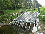
Inlet structure for the bottom outlet (3) with rake and inlet throttling

View along the dam crest (7) with lower-lying flood relief (2)

Flood relief (2) with driftwood rake

Outlet structure with fish ladder (4) and subsequent stilling basin (5)


Construction work sequence
The groundbreaking for the construction work took place on July 2nd, 2004. For the construction of the retention basin, a 900 meter long section of Jonentalstrasse had to be laid on the right side of the valley. In addition, part of the course of the Jonenbach had to be changed.
Before the embankment was backfilled, the 141-meter-long passage (1) for the Jonenbach was first created in the central area of the dam. This passage is made of concrete and was manufactured in stages of 7.5 meters in length. The outer diameter of the concrete passage structure is around four by five meters. This was followed by the flood relief (2), also made of concrete, with the almost 17-meter-high, shaft-shaped inlet structure that flows into the culvert. The space below the flood relief was lined with concrete. Most recently, the earth wall was filled with a dam volume of 123,000 cubic meters. The bulk material for this was partly supplied from the nearby N4 construction site in Knonaueramt .
In the course of the excavation work, a strongly fissured sandstone layer was unexpectedly discovered in the area of the left abutment, which, in contrast to the original detailed project, required additional injection measures.
The construction work was carried out by STRABAG AG and completed in May 2007. The client was the building department of the Canton of Zurich. The costs for the flood retention basin, including the necessary relocation of Jonentalstrasse and adaptation work on Aeugsterstrasse, amounted to around 13 million Swiss francs (approximately 8.5 million euros ). On May 24th, 2008 the building was presented to the population.
Conservation considerations
The basin above the flood retention dam is very rarely dammed and then only for a short time. It fills and empties within hours to a day at most. The vegetation is therefore not affected. With the construction of a retention basin, however, the dynamics of the water and the bed load are also interrupted. In the long term, this can lead to floor erosion in the section of the stream below and then to obstructions as well as to a smaller variety of structures. Investigations of the bed load budget on behalf of the building department of the canton of Zurich in 2014 confirm that the retention basin is permeable in normal years, while during large floods a retention of around 100 m³ per event can occur.
The lowest area of the basin directly in front of the dam is regularly flooded during minor floods. Therefore, in the present case, it was designed as a purely natural area. The Mülweiher is fed by a weir in the Jonenbach above the pond . Since this weir is not passable for fish and microorganisms, an additional bypass water has been created for these animals. A fish ladder has also been set up at the dam's outlet structure , so that the Jonenbach can be passed through for fish and microorganisms.

Information board at the flood protection basin
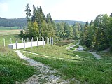
View from the dam on the 'green' basin with the Mülweiher

View from the Mülweiher to the dam

View from the dam on the municipality of Affoltern (with playground)


Flood protection after commissioning


On August 8th and 9th, 2007, the region was hit by a flood that is only expected to occur every 60 to 70 years. A total amount of precipitation of 80 to 130 mm was measured in the catchment area over two consecutive days. The soil was already partially saturated by previous rain, which quickly led to surface runoff. Within a few hours the pool was almost half full; the water level rose to 4.35 meters below the overflow edge of the flood discharge. With this retention, the outflow was throttled from 24 cubic meters to 14 cubic meters per second, so that the settlement area below the basin was spared from flooding, but also from mud and driftwood.
The event documentation of the Office for Waste, Water, Energy and Air shows: "This runoff could be discharged without damage in the Affoltern settlement area, only at the pedestrian bridge at the Büchi optician's shop (Alte Dorfstrasse) could it only become excessive with additional measures by the fire brigade in the form of Sandbags are prevented. The discharge capacity of the channel in the settlement area is practically exhausted with a discharge of 14 m 3 / s. If the HRB [HRB = flood retention basin] Affoltern am Albis had been fully dammed, around 2 m 3 / s more would have flowed away, which would have led to embankments in the current channel. For this reason, the throttle opening at the HRB was temporarily reduced after the event, so that in future a maximum of 14 m 3 / s will flow off even with a full build-up . "
The same report also states : “In the event documentation, the channel capacity in the settlement area was also assessed. [...] Even with a discharge of just under 12 m 3 / s (at the time of the inspection), 6 of the 28 cross sections examined showed an unsatisfactory freeboard and a further 7 a scarce freeboard. Local construction measures with little effort to increase the drainage capacity are recommended. In Zwillikon there were light floods, which did not cause any major damage. The known bottlenecks will be eliminated in the medium term. Only then should the throttle opening be set again as it was during the flood in 2007. "
A new stream had been created within the area of the retention basin. The water found a new path through the forest and carried away many trees.
The protective effect of the retention basin was confirmed again during the floods in April 2008, which occurred only a few months later. The strength of this flood, however, was less than that of 2007. In February 2021, the retention basin was able to successfully protect the location below from the flood.
Web links
- Heinz Hochstrasser: flood retention & lake regulation. AWEL Office for Waste, Water, Energy and Air, accessed on May 16, 2021 (film about the function of a flood retention basin using the example of the Jonenbach near Affoltern am Albis, as well as a brochure: How to plan a flood retention basin - a guide for planners and authorities (with example Jonenbach)).
- Andrew Faeh, Lena Petersen and André Müller: Flood from 8./9. August 2007 in the canton of Zurich. (PDF; 2.0 MB) Basler & Hofmann May 2009, archived from the original on December 31, 2013 ; accessed on September 14, 2012 (evaluation and documentation of an event - short version).
- Hans F. Wymann: Flood Affoltern am Albis 09.08.2007. Switzerland motifs, accessed on November 5, 2011 (images of the flood on August 9, 2007).
Footnotes
- ↑ a b c d e f g h i j k l AWEL: Office for Waste, Water, Energy and Air, information board: Flood retention basin on the Jonenbach to protect Affoltern am Albis
- ↑ a b c d e f g Flood protection on the Jonenbach. Archived from the original on January 14, 2005 ; Retrieved August 21, 2009 .
- ↑ a b c d e f Andrew Faeh, Susanne Eigenheer Wyler and Heinz Hochstrasser: Flood retention basins: progressive and proven. (PDF; 318 kB) (No longer available online.) Basler & Hofmann, archived from the original on April 30, 2015 ; accessed on November 8, 2009 (review article on the functioning of flood retention basins from UMWELTPRAXIS No. 55 / December 2008 pages 17–20).
- ↑ a b c d Heinz Hochstrasser: NEW REQUIREMENTS FOR WATER CONSTRUCTION - flood retention basin at Jonenbach, Affoltern am Albis, Switzerland H. Hochstrasser, M. Aemmer (605ff). (PDF) (No longer available online.) Pp. 605–618 , archived from the original on December 28, 2013 ; accessed on January 16, 2016 .
- ↑ a b Valentin Grünenfelder: Flood retention basin on the Jonenbach near Affoltern am Albis. (PDF; 83 kB) University of Applied Sciences Rapperswil, archived from the original on December 13, 2015 ; accessed on November 3, 2009 (brief description of a diploma thesis).
- ↑ a b c d STRABAG AG: Flood retention basin Jonenbach, Jonental, Affoltern am Albis. STRABAG AG Switzerland, archived from the original ; accessed on November 3, 2009 (description of the construction of the flood retention basin).
- ^ Hochstrasser, H .; Aemmer, M: Flood retention basin at Jonenbach, Affoltern am Albis, Switzerland. Fraunhofer Information Center for Space and Construction, accessed on November 1, 2009 (reports from the Research Institute for Hydraulic Engineering, Hydrology and Glaciology -VAW-; 208 from New Requirements for Hydraulic Engineering . International Symposium September 11-12, 2008. Vol. 2008. pp. 605-618).
- ↑ Visiting the flood retention basin on the Jonenbach above Affoltern am Albis. State Chancellery of the Canton of Zurich, accessed on October 27, 2009 (press release).
- ^ Hunzinger, Zahn & Partner AG: Strategic planning of bed load household Jonenbach . Ed .: Building Department Canton Zurich, Office for Waste, Water, Energy and Air. Aarau December 2014 ( zh.ch [PDF; accessed on May 8, 2021]).
- ↑ a b c Andrew Faeh, Lena Petersen and André Müller: Flood from 8./9. August 2007 in the canton of Zurich. (PDF; 2.0 MB) Basler & Hofmann May 2009, archived from the original on December 31, 2013 ; accessed on January 16, 2016 (evaluation and documentation of an event - short version).
- ^ Jonenbach, Affoltern retention basin. voluntary forum S9, accessed on November 3, 2009 (pictures of the construction phase and of the 2007 flood).
- ↑ Anzeiger district Affoltern: "Fortunately there is the Jonenbach retention basin!" Retrieved May 8, 2021 .