Hohenpölz
Hohenpölz (East Franconian: Habölz) is a village in Franconian Switzerland and part of the Markt Heiligenstadt i.OFr. .
The place has around 150 inhabitants. The district has an area of 757 hectares.
location
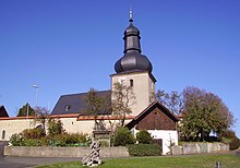
The 30 meter high, massive bell tower of the church with its onion dome can be seen from almost everywhere on the heights of the Franconian Jura for orientation. Hohenpölz is located at the northern end of the Heiligenstadt market. Neighboring towns are (clockwise) Laibarös , Huppendorf , Voitmannsdorf , Brunn , Oberleinleiter and the Heroldsmühle .
history
Surname
The Hohe Pölz is the counterpart to the lower Tiefen Pölz ( Tiefenpölz ). This distinction was not used until the 12th century. The spelling Hohenpölz did not appear until the 14th century and was first used when in 1345 Bishop Friedrich I von Hohenlohe zu Bamberg sold his inheritance and rights to 4½ Huben (Low German Hufe ) zu Hohenpolenez to the abbess of the St. Theodor monastery .
The name "Bolenze" or "Bolinze" was mentioned for the first time on August 6, 1096 in a document on the occasion of an exchange of goods in which an Arnolt de Bolence appeared as a witness.
prehistory
To the east of Hohenpölz there are early Celtic burial mounds. The cemetery was used by Celts between 700 and 400 BC. Created. Last excavations took place in 2004.
The burial mound field today consists of 41 mounds. Originally there were considerably more, but many of the hills were plowed so heavily that they are no longer visible today. Unrelated stones and shards of vessels provide evidence of such excavated mounds.
middle Ages
Around the year 700 Slavic settlers immigrated from the east, the so-called Wends . A relic of this time are place and field names of Slavic origin. These include the names of the villages of Tiefenpölz and Hohenpölz, as well as Laibarös and Treunitz .
Modern times
Hohenpölz was subordinate to the Hollfeld office. This lasted until 1862, the year it was merged with the Ebermannstadt District Court .
On January 1, 1971, Hohenpölz was incorporated into the Heiligenstadt market in Upper Franconia.
Early descriptions
Topographic description (1752)
In Biedermann's topographical description from 1752, Hohenpölz is described as follows:
- “Hohenbelz, a village with a Catholic church on the heights below the Scheßlitz office, one hour from Königsfeld, where the feudal lords partly underwent office, partly also the barons v. Aufseß belongs to her family home, the Plankenstein Castle and the senior council, which are thus incorporated into the Canton Gebürg. The church bears the name of St. Lorenz and is a branch of Königsfeld. The hunt is dome and is used by the Princely Hunters at Neuhaus, then also by those Barons v. and to Aufseß in the lower castle and visited by Baron von Aufseß in Königsfeld. Scheßlitz has the rule of the village and high jurisdiction. Two men are responsible for the Aufseß house from here to the main house or lower castle, along with 13 other people, two feudal people to the Plankenstein castle and various interest loans to the senior council. "
Joseph Heller (1829)
The Bamberg private scholar Joseph Heller described Hohenpölz in his description of the Muggendorfer Mountains (older name for Franconian Switzerland) in 1829 as follows:
- “Hohenpölz, Bambergisch, Catholic, in the Hollfeld district court . The place was otherwise called Polence and occurs as early as the 12th century. It is very high and is therefore seen far. Hohenpölz, Hohenmürsberg and Wichsenstein are the points that delimit the Muggendorf area. The church, a branch of Königsfeld, is well preserved and renovated in May 160 and 1820; it has three altars, on the main altar the image of St. Lawrence as the church patron. The place has two inns, 230 residents with the associated Heroldsmühle, above which the Leinleiter rises. "
School job description (1914)
In a school job description by the teacher Hugo Keller from 1914 it says:
- “Hohenpölz is 510 m above sea level, free on the Jura, with a wonderful view, has a rough but healthy climate, enough well water. The place is a separate political municipality with 49 houses and 249 inhabitants, belongs to the district office Ebermannstadt and Rentamt Wäinenfeld, post station is Heiligenstadt, train station Hollfeld. A doctor and pharmacy can also be reached there. The population does agriculture. Single teachers find excellent food in the inn. "
chronology
- 1174: Documentation by Bishop Hermann von Bamberg as "Bolenza" owned by the St. Theodor Monastery in Bamberg
- 1317–1322: Mentioned in the Würzburg fief book
- Around 1300 construction of the church tower as a refuge for the population
- 1690–1720: Construction of the nave of the church
church
→ Main article: St. Laurentius and Heinrich (Hohenpölz)
The Catholic branch church of St. Laurentius and Heinrich (patronage on August 10 and July 15) belongs to the parish of Königsfeld . The church building stands on a hill above the village and can be seen from afar.
Others
Hohenpölz is home to the Hohenpölz brass band , a music group that mainly performs traditional music. There is also the Hohenpölz Choral Society and the Hohenpölz Voluntary Fire Brigade .
Since the mid-1990s Hohenpölz has developed into a center of paragliding . On the corridor to the east, paragliders are lifted into the air using a winch.
literature
- Dieter Zöberlein: Community chronicle Markt Heiligenstadt i. OFr. Published on the occasion of the celebration of the 450th anniversary of the granting of market rights to Heiligenstadt i. OFr. - Heiligenstadt: 1995 (pages 261 to 278).
Web links
Individual evidence
- ^ Wilhelm Volkert (ed.): Handbook of Bavarian offices, communities and courts 1799–1980 . CH Beck, Munich 1983, ISBN 3-406-09669-7 , p. 451 .
- ↑ a b c Dieter Zöberlein: Community chronicle market Heiligenstadt i. OFr.
Coordinates: 49 ° 54 ' N , 11 ° 9' E


