
Holzminde
| Holzminde | ||
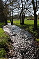
 Holzminde in the Solling upper Rumohrtal |
||
| Data | ||
| Water code | EN : 4536 | |
| location | Holzminden district , Lower Saxony | |
| River system | Weser | |
| Drain over | Weser → North Sea | |
| source | in Solling in the Mecklenbruch 51 ° 46 ′ 41 ″ N , 9 ° 33 ′ 29 ″ E |
|
| Source height | approx. 460 m above sea level NN | |
| muzzle | In Holzminden in the Weser Coordinates: 51 ° 49 ′ 36 " N , 9 ° 26 ′ 34" E 51 ° 49 ′ 36 " N , 9 ° 26 ′ 34" E |
|
| Mouth height | approx. 83 m above sea level NN | |
| Height difference | approx. 377 m | |
| Bottom slope | approx. 22 ‰ | |
| length | approx. 17 km | |
| Right tributaries | Drought in Holzminde | |
| Small towns | Holzminden | |
| Communities | Silberborn , Neuhaus im Solling , Fohlenplacken | |
The Holzminde , also known as the Red Water in the upper reaches , is an approximately 17 km long right or southeast tributary of the Weser in the Holzminden district in Lower Saxony ( Germany ).
course
The brook rises in the center of the Solling low mountain range just under 2.8 km south-south-west of the Großer Ahrensberg or around 2.6 km west-south-west of the Großer Ploess (distances as the crow flies ). It flows away at about 450 m above sea level. NN the high moor and nature reserve Mecklenbruch , which is near Silberborn .
The Holzminde initially runs in a south-south-west direction through Silberborn to Neuhaus im Solling , where it bends in a north-west direction. From then on it flows as a low mountain range with a typical floodplain landscape in a north-westerly direction through Fohlenplacken and the Rumohrtal along Kreisstraße 50, which connects Neuhaus with the town of Holzminden . It passes the Holzminden state forest in the north and the Boffzen state forest in the south.
After leaving the Solling, the Holzminde reaches the town of Holzminden in the Upper Weser Valley , where it flows through the Upper, Middle and Lower Ponds. Immediately in front of the first-mentioned pond, the Holzminde drought from the east flows into it, which is by far its largest tributary.
Immediately after flowing through the Holzminder urban area, the Holzminde empties at river kilometer 80 at about 83 m above sea level. NN into the Weser , which here forms a border section to the west of North Rhine-Westphalia .
Red water
The upper course is also called "Red Water", as Johannes Letzner already pointed out in connection with the relocation of the Hethis Monastery . This name refers to the reddish color in this section of the river, which comes from the middle peat moss or reddish peat moss in the Mecklenbruch.
photos

Holzminde in Neuhaus im Solling

Holzminde with pronounced meanders in the Rumohr valley
Holzminde in the lower Rumohrtal

Holzminde in the middle pond in Holzminden with drained pond water


Individual evidence
- ↑ Ulrich Kahrstedt: Hethis Monastery. In: Niedersächsisches Jahrbuch für Landesgeschichte, Volume 29, 1957, p. 196 ff