Inuvik
| Inuvik | ||
|---|---|---|
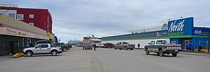
 Main Street in Inuvik |
||
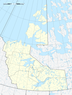
| Location in Canada | ||
|
|
||
| State : |
|
|
| Territory : | Northwest Territories | |
| Region: | Inuvik region | |
| Coordinates : | 68 ° 19 ′ N , 133 ° 37 ′ W | |
| Height : | 15 m | |
| Area : | 46.76 km² | |
| Residents : | 3243 (as of 2016) | |
| Population density : | 69.4 inhabitants / km² | |
| Time zone : | UTC-7 / UTC-6 | |
| Postal code : | X0E 0T0 | |
| Area code : | +1 867 | |
| Foundation : | 1954 | |
| Mayor : | Natasha Kulikowski | |
| Website : | inuvik.ca | |
 Inuvik in autumn |
||
Inuvik is a city in northwest Canada across the Arctic Circle . It has 3,243 inhabitants (as of 2016), the municipality area is 46.76 km², of which 5% are used. Politically, Inuvik belongs to the Northwest Territories . It is the largest city in Canada north of the Arctic Circle. Many newcomers of European origin live here, while the native Inuit are now the minority in the city.
location
Inuvik is located on the banks of the East Channel, the eastern arm of the Mackenzie Delta, around 100 km from the confluence with the Beaufort Sea , on a flat, wooded plateau near the northern tree line at the transition from the taiga to the tundra . From the site visitors have a far-reaching view of the Richardson Range, a 981 m high mountain range in the west across the Mackenzie on the border with the Yukon Territory . There, about 100 km to the west, is the neighboring community, Aklavik , the largest town in the wider area after Inuvik. Aklavik can be reached via frozen Mackenzie in the winter months. Since November 2017, a gravel road designed for year-round access has led to Tuktoyaktuk , which is about 150 km to the north on the Beaufortsee (at the beginning of June 2018 this road was closed to vehicles over 5000 kg).
climate
According to the Köppen and Geiger climate classification, the climate here is subarctic (Dfc).
From June to August the midnight sun shines for 56 days , while in winter the sun does not rise for several weeks. The annual mean temperature is −10 ° C, with a maximum of 31 ° C in summer and -57 ° C in winter. With an annual rainfall of 266 mm, it is rather dry, as the mountain ranges in the west largely keep the rain away.
| Inuvik, Northwest Territories | ||||||||||||||||||||||||||||||||||||||||||||||||
|---|---|---|---|---|---|---|---|---|---|---|---|---|---|---|---|---|---|---|---|---|---|---|---|---|---|---|---|---|---|---|---|---|---|---|---|---|---|---|---|---|---|---|---|---|---|---|---|---|
| Climate diagram | ||||||||||||||||||||||||||||||||||||||||||||||||
| ||||||||||||||||||||||||||||||||||||||||||||||||
|
Average monthly temperatures and rainfall for Inuvik, Northwest Territories
|
|||||||||||||||||||||||||||||||||||||||||||||||||||||||||||||||||||||||||||||||||||||||||||||||||||||||||||||||||||||||||||||||||||||||||||||||||||||||||||||||||||||
population
Today (as of 2018) over 60% of people of European origin live in the community (44% in 1991), as well as locals who belong to the Inuit (25%) or the Dene and Métis (15%). In addition to English, native languages are spoken, especially Inuktitut (Inuvialuktun) and Gwich'in .
Dempster Highway
The place, whose name means "place of the people" or "place of residence" in the language of Inuktitut , can be reached on the 736 km long Dempster Highway , a mostly unpaved road that begins near Dawson and ends in Inuvik.
history
The first European to reach the area was explorer Alexander MacKenzie , after whom the nearby stream is named, in 1789 .
The traditional center of the area was Aklavik, but in the 1950s it was decided to build a new community as Aklavik had to struggle again and again with flooding and erosion. The inauguration of the city, which was initially called East Tree in the planning phase , took place officially on July 18, 1958 by a proclamation at the 15th session of the Council of the Northwest Territories. In 1967 the place received community status and in 1970 city status. Richard Hill became the first mayor. The oil and gas industry as well as the military base established in Inuvik, which was closed in 1985, whereupon around 700 residents emigrated.
Attractions
One of the sights is the igloo-shaped church of the village ( Igloo Church Our Lady of Victory , built in 1960 by Maurice Larocque and Joseph Adam). In addition, there is the Ingamo Hall Friendship Center , which was built in 1976/1977. A sports center has existed since 1997 with the Midnight Sun Recreation Complex . In 1995 the Western Arctic Visitor's Center was also opened. The Canadian government also operates a research laboratory in Inuvik. Since 2010, Inuvik has had Canada's northernmost mosque for the 150 to 200 Muslims living here.
The airfield ( Mike Zubko Airport ) with an approx. 2000 m long runway is located a good 10 km south of the village and is approached daily by jet planes. In the village there is only one intersection with a traffic light. Many Inuvik buildings are heated with water vapor through a pipe system. The water supply must come from Lake B or the local lake, the Hidden Lake, as the East Channel contains brackish water, especially in summer. Because of the permafrost , the city's buildings are built on stilts. There is an infirmary and several administrative buildings in the village (each since 1960). In 2003 Inuvik received a modern hospital with 26 beds and 9 doctors. The CBIC has a bank branch in Inuvik, the Canadian Post Office also has a branch here. There are also 6 hotels and motels in town . Also worth mentioning is a greenhouse with an area of approx. 500 m². This greenhouse was established through the renovation of the Grollier Hall boarding school . It is not heated, so it does not remain frost-free in winter, but it extends the summer vegetation period considerably. The residents of the city can lease small beds for their own use, which means that the greenhouse fulfills an important social function and offers an otherwise impossible experience of nature in these latitudes. Recently there is also a small apple tree in the greenhouse. There is also a small theater, the Inuvik Delta Theater .
Education and Research
There is the Aurora College in town , which is a member of the University of the Arctic .
On August 10, 2010, the German Aerospace Center (DLR) inaugurated the Inuvik Satellite Station . The DLR uses the new ground station, among other things, to receive data for the TanDEM-X satellite mission .
sons and daughters of the town
- Floyd Roland (born 1961), Canadian politician
- Leona Aglukkaq (* 1967), Canadian politician
- Eric Schweig (* 1967), actor
- Jason Elliott (* 1975), Canadian former ice hockey goalkeeper
economy
Inuvik is the base of the oil and gas industry, which operates in the Mackenzie Delta area. 1969 were in the region of oil and in 1970 also discovered gas reserves. There is a shipyard on the banks of the East Channel.
Web links
Individual evidence
- ^ Inuvik A. Canadian Climate Normals 1981-2010. Environment and Climate Change Canada , June 11, 2019, accessed September 15, 2019 .
- ↑ Nicki Thomas: Little mosque on the tundra . In: The Star , September 24, 2010, accessed May 3, 2018.
- ↑ Jörg Michel: A minaret covered by snow . In: Frankfurter Rundschau , May 3, 2018, accessed on May 3, 2018.
- ^ DLR: Inauguration of the first DLR ground station in Canada. August 10, 2010, accessed June 16, 2018 .

