Jamuna
| Jamuna | ||
|
Jamuna with Bangabandhu Bridge |
||
| Data | ||
| location | Bangladesh | |
| River system | Meghna | |
| Drain over | Brahmaputra → Padma → Meghna | |
| Crossing the India-Bangladesh border |
Brahmaputra 25 ° 56 '32 " N , 89 ° 50' 9" E |
|
| Source height | 16 m | |
| Association with |
Ganges to Padma Coordinates: 23 ° 48 ′ 42 " N , 89 ° 45 ′ 2" E 23 ° 48 ′ 42 " N , 89 ° 45 ′ 2" E |
|
| Mouth height | 6 m | |
| Height difference | 10 m | |
| Bottom slope | 0.04 ‰ | |
| length | 245 km | |
| Catchment area | 552,000 km² | |
| Drain |
NNQ MQ HHQ (1998) |
2860 m³ / s 20,100 m³ / s 102,500 m³ / s |
| Right tributaries | Gangadhar , Torsa , Dharla , Tista | |
| Medium-sized cities | Sirajganj | |
| Navigable | along its entire length | |
| Section of the Brahmaputra Meghna stream | ||
|
The Jamuna in the Meghna river system with Brahmaputra and Ganges |
||
|
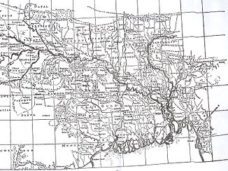
The situation mapped by Rennel in 1764: small watercourses in place of the Jamuna, Brahmaputra flows to the east without the Ganges |
||
Jamuna ( Bengali যমুনা Yamunā [ dʒɔmuna ]) is the name of the Brahmaputra main line in Bangladesh and at the same time the third from last of the many named different sections of the largest river course in Asia . The Jamuna has an average water flow of 20,100 m³ / s. It is not to be confused with the Yamuna River in India.
course
Shortly after the transfer of the Brahmaputra from the Indian state of Assam to Bangladesh, it was given the name Jamuna . After 245 kilometers of flow in an interwoven river bed up to 14 kilometers wide (near Sirajganj) interspersed with wandering sandbanks ( Chars ), it joins the main branch of the Ganges flowing in from the right (from the west) (mean natural discharge: 11,400 m³ / s ) and from then on bears the name Padma .
River history
At two points, at the beginning of the Jamuna and around 50 kilometers downstream, smaller watercourses split off on the left, which unite to form the Old Brahmaputra . It marks an earlier course of the Brahmaputra, which ran so far to the east that it and the Ganges flowed into the Bay of Bengal almost separately from each other. This former situation is still reflected in the naming of the waters, even if the main streams run very differently today. This explains the similarity of names to very different river sections such as Brahmaputra, Padma or Meghna, but also the name changes in the course of the main river. Today's Jamuna follows the Konai-Jenai watercourse, a former lower course of the Tista tributary, which changes widely in its flow paths . It crosses two flood-free river terraces ( Barind and Madhupur plateau; some remains of alluvial fans ), which separate the lowlands of the Old Brahmaputra in the northeast and the Ganges in the southwest. The shift of the Brahmaputra to the west, i.e. via today's Jamuna to the Padma, is explained by tectonic uplifts in the western Ganges delta and the Old Brahmaputra, especially after an earthquake in 1782 and a flood disaster in 1787, during which the Tista also ran its course shifted from the Ganges to the just forming Jamuna.
use
The Jamuna is an important shipping route, despite the very changeable stream channels, as the large stream channels are on average 5 meters deep. However, the wide river bed with channels 1–3 km wide, even at low tide , was a major obstacle to traffic between the capital Dhaka and the northern division of Rajshahi . In 1998 this connection with the 4.8 kilometer long Bangabandhu Bridge , the eleventh longest river bridge in the world, was created, combined for road and rail traffic.
Surname
The name Jamuna became official after the establishment of the state of Bangladesh. Jamuna is the Bengali pronunciation of the river name Yamuna . A river called the Yamuna also flows in India . This is the most important tributary of the Ganges and is worshiped by the Hindus as the goddess Yamuna . Like almost all Hindu god names, Yamuna / Jamuna also serves as a (female) first name.
Web links
- Jamuna at Banglapedia
Individual evidence
- ↑ Catchment areas of major rivers ( Memento of the original from July 6, 2011 in the Internet Archive ) Info: The archive link was automatically inserted and not yet checked. Please check the original and archive link according to the instructions and then remove this notice. Retrieved from www.jrcb.gov.bd on December 20, 2013
- ↑ MQ: [1] (PDF; 4.1 MB), HQ and NQ: [2]
- ↑ Jun Jian, Peter J. Webster, * Carlos D. Hoyos: Large-scale controls on Ganges and Brahmaputra river discharge on intraseasonal and seasonal time-scales (PDF; 4.1 MB) QJR Meteorol. Soc. 135: 353-370 (2009), today's mean discharge reduced by diversion to Bhagirathi at Farakka Dam
- ↑ VN Mikhailov, MA Dotsenko: Processes of Delta Formation in the Mouth Area of the Ganges and Brahmaputra Rivers ( Memento of the original from April 25, 2016 in the Internet Archive ) Info: The archive link was inserted automatically and has not yet been checked. Please check the original and archive link according to the instructions and then remove this notice. (PDF; 444 kB)
- ^ Avijit Gupta: Large rivers: geomorphology and management , 2007


