
Jasperallee
| Jasperallee | |
|---|---|
|
|
|
 |
|
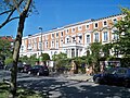
| Jasperallee in the western section | |
| Basic data | |
| place | Braunschweig |
| District | Eastern ring area |
| Created | 1889-1936 |
| Hist. Names | Kaiser-Wilhelm-Strasse Friedensallee |
| Connecting roads | At the Herzogin-Elisabeth-Strasse theater |
| Cross streets | Moltkestrasse Bismarckstrasse Kasernenstrasse Steinbrecherstrasse Hagenring Altewiekring At the Paulikirche Blücherstrasse Olfermannplatz Gneisenaustrasse Lützowstrasse Wilhelm-Bode-Strasse |
| Buildings |
Paulikirche Oskar-Kämmer-Schule (headquarters) Colonial monument |
| use | |
| User groups | Pedestrian traffic , bicycle traffic , car traffic , public transport |
| Technical specifications | |
| Street length | 1.1 km |
.jpg)
The Jasper Avenue in Braunschweig leads from the State Theater straight east-north to Franz's field before Nußberg .
The approximately 1.1 kilometer long avenue is the main axis of the eastern ring area and has been named after Heinrich Jasper (1875-1945) since 1946 . In the 1920s he was Prime Minister of the Free State of Braunschweig and from 1930 to 1933 chairman of the SPD parliamentary group in the Braunschweig State Parliament .
Plant and traffic
The Jasperallee consists of two separate lanes, which are provided with parking lanes except for the area in the city park. In the eastern section the street has a cobblestone pavement . In the middle of the street there is a green strip along its entire length, which is only interrupted by cross streets. In the western part there is a paved promenade in the middle of the green strip, which becomes a beaten path to the east and is overgrown with grass in the eastern part. The area in the middle was planted (from west to east) with two rows of maples (mostly silver maple ), oak and plane trees; the maples were felled in 2019 and are to be replaced by winter linden trees. Along the entire length of Jasperallee, low metal fences separate the green strip from the street.
The road is not used as an access road, so car traffic is moderate. At the same time, it is the main axis of the eastern ring area. Two bus routes operated by Braunschweiger Verkehrs-GmbH run through the entire Jasperallee; other bus routes use the western part of the road to Hagenring. Stops on Jasperallee are “Kasernenstrasse”, “Jasperallee” and “Stadtpark”.
history
In the western part of today's Jasperallee was the Ducal Kitchen Garden , which was released for development in 1889. In the same year, the "Kaiser Wilhelm Bridge" (today Theater Bridge ) was opened for pedestrians over the eastern flood ditch of the Oker ; In 1902 she received figurative jewelry based on plans by Ernst Müller-Braunschweig . In the further course to the east, the section to the intersection of Hagenring / Altewiekring and in 1906 the section to the city park was built as "Kaiser-Wilhelm-Straße", named after Wilhelm I. Before that, the Brunnenstraße ran there in a similar location. The street was equipped with two rows of trees in the middle of the street with a promenade and bridle paths based on the model of the Berliner Straße “ Unter den Linden ” . The development took place around 1900 according to the demands of the wealthy bourgeoisie with about three-story houses in the style of the Wilhelminian era with large apartments along the entire street.
In 1898 the bridle paths were replaced by a tram route , which from 1909 ran along the entire length of the then street.
From 1928 the street was called "Friedensallee", but was renamed Kaiser-Wilhelm-Straße as early as 1933 after the NSDAP came to power . For rallies and marches on Franzschen Feld during the Nazi era , the avenue that was extended to the east through the city park in 1936 was to serve as the main connection to the city center. During the air raids in World War II , numerous houses on Kaiser-Wilhelm-Strasse were bombed.
After the end of the war, the street was named after the Braunschweig SPD politician Heinrich Jasper , who died in February 1945 in the Bergen-Belsen concentration camp . The damaged houses were restored or replaced by simple houses of roughly the same size. The burnt spire of the Paulikirche was not restored. The figures on the Oker Umflutgraben bridge were also not renewed. The tram line was shut down in 1955 and then dismantled.
Buildings
Most of the houses are for residential purposes. There are also doctors' practices, law firms, educational advice and a private educational institute. There are two banks at the intersection with Hagenring. The defining building is the neo-Gothic Paulikirche on the north side of Jasperallee, the center of the eastern ring area. It was built in the course of the construction of Jasperallee and, like the corresponding section of Jasperallee, was inaugurated in 1906. In the city park on the north side of Jasperallee is the colonial monument , which commemorates the loss of the colonies in the First World War.
The mathematician Richard Dedekind lived in Jasperallee 87 .
Others
As is customary in the Braunschweig core city, the house numbers were assigned according to the horseshoe numbering system , starting with 1 on the Umflutgrabenbrücke on the north side and ending with 87 on the south side of the bridge.
Impressions

View over the eastern ring area from the northwest; Jasperallee runs roughly from the lower right corner to the center of the picture

West end with theater bridge over the Oker flood ditch
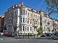
The "Bremen houses" on the north side
Houses on the corner of Jasperallee and
Steinbrecherstraße
Paulikirche , seen from Jasperallee
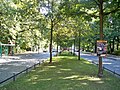
Jasperallee in the city park
.JPG)
.JPG)


.jpg)

.jpg)
literature
- Luitgard Camerer, Manfred Garzmann, Wolf-Dieter Schuegraf, Norman-Mathias Pingel (eds.): Braunschweiger Stadtlexikon. Meyer, Braunschweig 1992, ISBN 3-926701-14-5 , p. 116.
- Jürgen Hodemacher : Braunschweig's streets - their names and their stories, Volume 2: Okergraben and Stadtring. Cremlingen 1996, ISBN 3-927060-12-7 .
- Wolfgang Kimpflinger: Monument topography Federal Republic of Germany . Architectural monuments in Lower Saxony. Volume 1.2 .: City of Braunschweig. Part 2. Hameln 1996, ISBN 3-8271-8256-5 .
- Ernst-August Roloff : 100 years of the middle class in Braunschweig. Volume 1: From Jasperallee to Kaiser-Wilhelm-Straße. Verlag Hans Oeding, Braunschweig 1985, ISBN 3-87597-009-3 .
- Ernst-August Roloff: 100 years of the middle class in Braunschweig. Volume 2: Tradition and Change. Life stories from a middle-class residential area. Verlag Hans Oeding, Braunschweig 1987, ISBN 3-87597-010-1 .
Web links
Individual evidence
- ↑ Jasperallee on the website of the city of Braunschweig , accessed on February 3, 2016
- ↑ Reinhard Bein : Braunschweig. City and duchy 1890–1918. Döring Druck, Braunschweig 1985, ISBN 3-925268-01-4 , p. 26.
- ↑ see historical map in this article
- ↑ a b Private website for tram line 6 , accessed on 23 August 2011
Coordinates: 52 ° 16 ′ 5 ″ N , 10 ° 32 ′ 24 ″ E