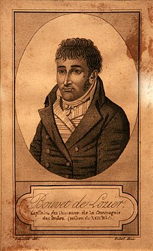
Jean-Baptiste Charles Bouvet de Lozier
Jean-Baptiste Charles Bouvet de Lozier (born January 14, 1705 from the area around Pleudihen-sur-Rance , † 1786 in Saint-Malo ) was a French navigator and explorer.
Live and act
After studies of navigation, he was a lieutenant in 1731 the French India Company Company both India, Compagnie des Indes . In 1733 he proposed an expedition to the company , consisting of a frigate and a larger merchant ship, in order to find land in the South Seas on which the East Indiamans could find shelter and supplies. Not modestly, he insisted on being made governor of each of his future discoveries.
On July 19, 1738, he set sail with Aigle and Marie from Lorient and set course for Santa Catarina Island off the coast of Brazil . He arrived there in October, equipped himself again and left the island a month later heading southeast. In December he was at the 45th parallel , but after days of fog he saw nothing but an iceberg , later penguins , which he described as “like ducks but with fins”.
In late December he was in the South Atlantic between icebergs, 1,600 miles from any inhabited land. On January 1, 1739, at 3 p.m., a "very high snow-covered land" emerged from the fog. He thought it was a promontory of the southern continent Terra Australis and named it after the day of its discovery, the feast of the circumcision of Christ, Cap de la Circoncision .
After being unable to land for twelve days and his crew suffering from scurvy , he continued east until he had to give up because of the illness. On February 5, the two ships parted and Mr. Hay took the Aigle to the Isle de France (Mauritius) . Mr. Bouvet arrived at the Cape of Good Hope on February 24th with Marie without loss of a husband and was back in Lorient on June 24th. He had to inform his clients that a southern continent had to face the pole and was therefore out of the question for supply options.
A brief description of the expedition can be found on a nautical chart from September 5, 1739 in the Bibliothèque nationale de France.
Although disappointed with his ride himself, Bouvet was admired and honored. Twice, 1750–1752 and 1757–1763, he was governor of Réunion and 1750–1756 of Mauritius . The land he discovered was later called Bouvet Island ; one of the northern capes of the island is called Cape Circoncision .
Individual evidence
| personal data | |
|---|---|
| SURNAME | Lozier, Jean-Baptiste Charles Bouvet de |
| BRIEF DESCRIPTION | French navigator and explorer |
| DATE OF BIRTH | January 14, 1705 |
| DATE OF DEATH | 1786 |
| Place of death | Saint Malo |
