
Jubachtalsperre
| Jubachtalsperre | |||||||
|---|---|---|---|---|---|---|---|
 |
|||||||
|
|||||||
|
|||||||
| Coordinates | 51 ° 9 '43 " N , 7 ° 36' 29" E | ||||||
| Data on the structure | |||||||
| Construction time: | 1904 to 1906 | ||||||
| Height above valley floor: | 23.7 m | ||||||
| Height above foundation level : | 27.7 m | ||||||
| Building volume: | 32 000 m³ | ||||||
| Crown length: | 152 m | ||||||
| Crown width: | 4.5 m | ||||||
| Base width: | 19.2 m | ||||||
| Data on the reservoir | |||||||
| Altitude (at congestion destination ) | 343.7 m above sea level | ||||||
| Water surface | 11.7 ha | ||||||
| Reservoir length | 850 m | ||||||
| Reservoir width | 150 m | ||||||
| Storage space | 1.05 million m³ | ||||||
| Catchment area | 6.81 km² | ||||||

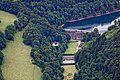
The Jubachtalsperre was built between 1904 and 1906 according to the plans of the Aachen civil engineer Otto Intze in the area of today's town of Kierspe in the Märkisches Kreis . The dam serves to supply drinking water and can be circled on a 2.7 km long path.
The gravity dam, built from rubble stones, has a height of 27.7 m with a crown width of 4.5 m and a length of 152 m. With a maximum storage volume of 1.05 million m³ (at a height of 343.7 m above sea level), the largest possible surface of the lake is 11.7 ha. The Jubach , a tributary of the Volme, is dammed .
The operator of the system was initially the Volme water association, now the Lüdenscheid water procurement association.
Access to the Jubachtalsperre is possible via a junction from the B 54 in the village of Vollme, which belongs to Kierspe .
From 1990 to 1991 the dam wall was reinforced and sealed with a reinforced concrete cut- off wall and provided with an inspection passage. The drainage and the measuring equipment were renewed.
In August 2009, work was carried out again on the top of the wall.
The Fernhagener Bach and Jubachtal nature reserve begins at the eastern end of the lake .

Dam wall

Dam wall

Access was blocked during renovation work in 2009

View on the circular route

The dam


