
Cologne belt

The Kölner Gürtel is a ring road in Cologne that surrounds Cologne on the left bank of the Rhine in a semicircle. The individual sections of the belt are named after the districts or larger complexes that are crossed. The crossroads with the large radial arterial roads usually form the boundaries of the individual belt sections.
Belt in the system of road rings
Within the system of the more important Cologne road rings , the belt - counted from the city center - is the third ring after the rings and the inner canal road with its continuations in the inner green belt . The other road rings are the military ring in the former Cologne fortress ring and the Cologne motorway ring .
history
In contrast to the other inner-city road rings, which, together with the ramparts in front of the city wall and beyond the bastions as inner rings, can be traced back to the military history of Cologne through their emergence as part or as successor institutions and which were created according to uniform and simultaneous planning Belt roads were laid out at different times. Except for the motorway ring, they are also the youngest ring roads. The final expansion in the north of Cologne, which has always been requested, is still pending. The expansion of the settlements around the once walled city took place in the 19th century along the radial arterial roads; only rarely have broader cross-connections been established. These older parts can be recognized by the lack of a central green strip and the buildings in the Wilhelminian style . The beginning of the belt on the banks of the Rhine in Bayental was probably still isolated around the turn of the 20th century (construction of the Bismarck tower there in 1902). The expansion of Klettenberg, Sülz and Lindenthal beyond the Gürtel took place in simple apartment buildings, mostly through housing associations in the years after the First World War . There is therefore a lack of spectacular buildings. The churches of the city districts are also more likely on the radial streets or squares in the district. Exceptions are the St. Bruno facade church on the Klettenberggürtel (from 1924/26) and the Paul Gerhard Church on the Lindenthalgürtel.
Until the 1950s, the belt only ran from Klettenberg to Nippes. The later connection to Bayenthal often runs through green spaces and former factories. Because of the low crossing under the railway line with the Cologne Eifeltor transshipment station , the road there is only one-lane. The newer routes also stand out because of their car-friendly layout. This is clearly visible in the non-cultivation route of the Niehler belt in front of the Mülheimer bridge .
course

Bayenthal belt
The belt begins in the south of the city on the banks of the Rhine. As the Bayenthal belt, it forms the border between the adjacent districts of Bayenthal in the north and Marienburg in the south. In this section, the Gürtel is predominantly an upscale residential area with no industrial or business locations. With sycamore -lined avenue ends after numerous junctions and intersections with small, mostly with villas built, roads at the junction with the Bonner Straße.
Raderberg belt

The Gürtelstrasse continues after Bonner Strasse as the Raderberggürtel to Brühler Strasse. Here the area is open and manageable, the multi-lane directional lanes are separated by a strip of green planted with young plane trees. The Raderberg Belt is dominated by the distinctive high-rise buildings of Deutsche Welle and Deutschlandfunk, which were completed after six years of construction and inaugurated in 1980. The rest of the development on the Gürtelstrasse, which separates the districts of Raderberg in the north and Marienburg in the south, is sparse.
Raderthal belt

The Raderthalgürtel also has a median strip, free of intersections between the Brühlerstrasse and the Vorgebirgstrasse . It cuts through the south green corridor, which adjoins the foothills park created by Fritz Encke in the years 1910–1913 . The only further side street of the belt is the small Leichweg , on the corner of which the Zollstockbad is located. After the relocation of an industrial company (car paints, paints) that has been based at Leichweg for more than 120 years to Marsdorf , the Raderthalgürtel is free of immediate development except for a residential complex that is perpendicular to it. The European School Cologne is on the opposite side.
Folding rule belt

As a ruler belt , the street continues from Vorgebirgstraße and crosses the main shopping street of the district, Höninger Weg, with the tram (line 12) that runs through it. In the further course in the direction of Klettenberg , the Gürtel is provided with a median strip up to the height of "Kalscheurer Weg" and then becomes single-lane for both directions in its last section. The ruler belt, which has a closed development in its first section, has an open design and commercial settlements on the side facing the south cemetery . The yardstick belt ends at the DB underpass of the railway line that extends here to the Cologne Eifeltor transshipment station .
Klettenberg belt to urban forest belt
This is followed by the Klettenberg belt and from the intersection with the Luxemburger Straße the Sülz belt . Then from Zülpicher Straße at the level of the university clinics in the Lindenthal belt .
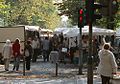
Market on the Klettenberg belt

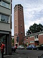
St. Bruno, climbing belt

KVB station Venloer Str./Gürtel

Paul Gerhard Church, Lindenthal Belt


After crossing Dürener Straße, the city forest begins on the west side behind a few short streets lined with villas and the street is called the city forest belt.
In a villa on Stadtwaldgürtel 35, which at the time belonged to the Cologne banker Kurt Freiherr von Schröder , an agreement was reached on Hitler's Chancellorship on January 4, 1933 at a meeting between Franz von Papen and Adolf Hitler . This meeting is considered to be the "hour of birth of the Third Reich " ( Karl Dietrich Bracher ). A commemorative plaque is embedded in the pavement in front of the house.
If you continue along the Gürtel, you cross the Aachener Straße , which runs almost straight to the west . From here the Melaten belt leads west along the Melaten cemetery .
Ehrenfeldgürtel

After crossing with Vogelsanger Straße in Ehrenfeld , the Ehrenfeld belt begins. It initially runs through the large former Ehrenfeld industrial area from the late 19th century, past the site of the former Helios AG for electrical light and telegraph construction . This company, founded in 1882 from the pioneering days of electrical engineering , made a significant contribution to the electrification of industry, transport technology and public space throughout Europe . The Rheinlandhalle is clearly visible from the Ehrenfeldgürtel, formerly a large assembly hall of the Helioswerke, then an event hall and now used by furniture, bicycle dealers and a fitness studio. In the background, an experimental and demonstration lighthouse from the Helioswerke is still shining as a landmark of Ehrenfeld.

The Gürtel then crosses Venloer Straße ( Bundesstraße 59 ) and the underground tram lines 3 and 4 at the Venloer Straße / Gürtel stop. It is also flanked by industrial monuments , such as the building complex of the machine and crane factory Voss and Maack, which, like the Helioswerke, was founded in 1882. After an eventful history, the company went out in 1990. The factory buildings were renovated and are now used as sales and event rooms, equipped with studio technology for television recordings. A “Voss crane” from 1937 is still operational in the former workshop.

At the Cologne-Ehrenfeld train station, the Gürtel now passes under the Cologne S-Bahn and the Cologne – Aachen high-speed line . The railway line, initially at ground level, was built as an arched viaduct at the beginning of the 20th century and cuts through Ehrenfeld in an east-west direction.
Behind the railway underpass, the Ehrenfeldgürtel crosses the site of the former Ehrenfeld glassworks . The hollow glass factory founded in 1864 by Phillip Michel with Bohemian specialists had up to 500 employees. The company, which is in changing ownership, used gas firing for the series production of household glasses, drinking services and glass rims from the 1870s. They also specialized in replicating antique glass vessels by hand; Ehrenfeld's glassware was exported to Germany, Europe and the world. After a first shutdown in 1928, the plant was finally closed in 1937. Even today, the Glasstrasse and the Hüttenstrasse near the belt are reminiscent of the Ehrenfeld glassworks.

The Reichspost acquired part of the property of the disused glassworks in 1937 . From 1966 to 1968 she built the new Ehrenfeld post office on the Ehrenfeldgürtel. The post office has since been relocated to Venloer Straße.
After the intersection with Subbelrather Straße, where the tram line 5 from the city center joins the Ehrenfeldgürtel, the street runs like an avenue through the Neuehrenfeld district . With the development of this new part of the city at the turn of the century, entire streets were built for citizens with homogeneous income and demands on the quality of living. The area called "Subbelrath" between Subbelrather and Nussbaumer Straße belonged partly to the landowners Alois Anton Schlösser (* 1845, † 1908) and Franz Zilkens (* 1847, † 1915). Schlösser turned his plots to petty bourgeois customers such as craftsmen, small merchants and skilled workers, while Zilkens sold his properties, including large parts of Eichendorffstrasse , which crosses the belt, and the area around St. Anne's Church, to wealthy clients. The vernacular called the resulting streets “Ink Veedel” or “Ink Blot Quarter” because their residents usually earned their money at their desks. Also along the belt are well-preserved magnificent buildings with richly decorated Art Nouveau facades, also in the branching and crossing side streets.

On the corner of Eichendorffstrasse, Café Franck , which has existed since 1938, is worth mentioning (previously Hans Büttgen). Even after the death of her husband Heinz in 1985, Susanne Franck continued to run the Cologne institution for a total of 64 years until she had to close the café in 2002 at the age of 91. In 2004 it was reopened under the same name by other owners who now run the café with an outdoor terrace during the day and a lounge bar (with a disco in the former bakery) in the evening . The furniture in the design of the 1950s ( kidney table ) was largely retained.
Further course
Even before crossing the A 57 autobahn from Nussbaumerstraße in the Bilderstöckchen district , the street was called Parkgürtel because it crossed the Blücherpark . If you follow the Gürtel further north from Geldernstrasse, it ends with the Mauenheimer Gürtel on Merheimer Strasse.
Niehler belt
The further extension to the bank of the Rhine has been planned for more than 40 years, but has not yet been carried out. Only the light rail has been in operation since 1974 as an elevated railway line in the middle of the planned route. So far, only a small section of the Niehler Gürtel has been realized, which has now been integrated by name into the Niehler Kirchweg. There are only two houses and an Aldi supermarket on the cul-de-sac that branches off parallel to the elevated railway. Assuming the future expansion, the houses were given the postal addresses Niehler Gürtel 102 to 106.
Only from Boltensternstraße in Riehl is the Gürtel - now known as the Niehler Gürtel - accessible again for motor vehicle traffic. From there it runs like a freeway to the Mülheimer Brücke .
Belt Railway

The Gürtel is accompanied by a tram running in the middle from the intersection with Luxemburger Straße heading north to Mülheimer Brücke. As far as Ehrenfeld, the route runs largely on the wide median, from then on the new section built as an elevated railway follows with a short section of tunnel. Line 13 runs along the entire route, and lines 5 and 7 of the Cologne city railway also operate on other short sections .
Urban development system
Most of the belt is a four-lane road. In the middle there is a wide median strip planted with trees, on which the tracks of the light rail also run. The road has bike lanes on both sides. This green strip is absent in the older parts of the belt. From the southern end to Bilderstöckchen, the belt is usually accompanied by multi-storey residential buildings. In between there are some office and commercial buildings, two parks and the Melatenfriedhof.
There are no representative buildings on the older parts of the belt. These are more likely to be found on the radial roads. As exceptions, the combined pool on the Raderthal belt and the Paul Gerhard Church on the Lindenthal belt could be mentioned. Since there was still a lot of building land available on the new street, many larger public and private buildings were built on or in the immediate vicinity of the Gürtel. Newer buildings include the DKV administration high- rise and the Regent Hotel at the intersection with Aachener Strasse, and the district town hall for the Nippes district at the intersection of the not yet finished route with Neusser Strasse . A landmark is the house of Deutschlandfunk with the neighboring house of the former Deutsche Welle in Marienburg. School buildings such as the Archbishop's Irmgardis Gymnasium in Cologne , the narrow side of which meets the Bayenthal Belt, or churches such as the Church of the Holy Spirit , which is officially located on Hürther Strasse, can also be mentioned.

Archbishop's Irmgardis High School
Tower of the Holy Spirit Church, folding rule belt / Hürther Straße

Raderberg Belt, former Deutsche Welle


Traffic importance
The belt has no supra-local function. But it is important for inner-city traffic because it connects different parts of Cologne without having to drive into the center. It is an important link, especially for cyclists and users of local public transport. For motor vehicle traffic it is not as important as the inner canal road, which runs about two kilometers into the city and is the most heavily traveled road on the Cologne road rings, with four to six lanes.
Expansion plans
The gap in the north between the end of the contiguous belt on Merheimer Strasse and the Niehler belt has been planned for many years. However, due to the financial situation of the city of Cologne, a time frame is not foreseeable. The residents in the northern part also fear a sharp increase in traffic in this case. The planned southern extension of the tram route to Bonner Strasse is also suspended due to the unclear financing.
The idea of another Rhine bridge at the southern end of the belt, however, has disappeared from the planning, as there is no longer any need for it.

Riehler belt
In the Riehl district, the Riehler Gürtel with the St. Engelbert Church (by Dominikus Böhm 1930/1932) runs from Amsterdamer Straße to the rear entrance of the Cologne Zoo on Stammheimer Straße . In terms of urban planning, it resembles the rest of the belt, i.e. a wide street with a wide median. However, there is no connection to the rest of the belt. The Riehler Gürtel is located on the route that was planned in the 1920s, so the name was retained. Later planning envisaged a more northerly route for the belt.
Web links
Individual evidence
- ^ Karl Baedeker : Cologne and surroundings , Hamburg 1954 p. 108
- ^ See Ulrich S. Soénius / Tobias Kaufmann: Adolf Hitler's Cologne meeting . In: Kölner Stadt-Anzeiger , January 4, 2008
- ↑ Johannes Maubach: In the footsteps of the old Ehrenfeld industry , Flock, Cologne 2005, p. 67/68
- ↑ ohannes Untermaubach: On the trail of the old Ehrenfelder industry , S. 143/144
- ^ Henriette Meynen: residential buildings in Cologne-Ehrenfeld; Aspects of the development and shape of a suburb , p. 7
- ↑ Johannes Maubach: Quer durch Ehrenfeld, Ehrenfelder Geschichtspfad (Part 2) , self-published, Cologne 2002, p. 28
- ↑ Johannes Maubach: Quer durch Ehrenfeld, Ehrenfelder Geschichtspfad (Part 2), p. 24