
Kalø Vig
| Kalø Vig | ||
|---|---|---|
 Kalø Vig recorded by Uggelsbølle . In the background Kalø Castle and Mols Bjerge. |
||
| Waters | Aarhus Bay | |
| Land mass | Mols | |
| Geographical location | 56 ° 15 ′ 0 ″ N , 10 ° 25 ′ 0 ″ E | |
|
||

Kalø Vig is a Danish bay in the Baltic Sea on the north shore of Århus Bay on the coast of the Mols landscape on the Djursland peninsula .
geography
The bay is bounded to the east by Mols Bjerge and the Skødshoved peninsula , and to the west by the area north of Århus . It is named after the island of Kalø with its castle of the same name and the Danish word Vig for small bay . The almost completely closed Knebel Vig branches off from the bay to the east .
At the north end is the island of Kalø with its castle ruins. The island has been linked to the mainland by a dam for centuries. A little east of the castle ruins is a marina , two more marinas are on the west coast near Egå . The Studstrup power plant is located on the west coast .
On the Kalø Vig are the villages Egå , Rønde , Egens , Vrinners clockwise .
history
The castle Kalø and the mansion is located near Kalø Manor were 1939 listed building set. The whole region around the bay of Kalø Vig was included in the newly established Mols Bjerge National Park in 2009 and added to the list of Danish national parks in order to protect and preserve the entire landscape. In 1985 the unofficial world championship of the folk boat class in sailing , the gold cup , was held here . The Danish boat Swallow from Egå won the regatta.

Kalø Vig taken from Trehøje in Mols Bjergen. In the background the Studstrup power plant .

The 500 m long, quarry stone paved hiking trail on Kalø Vig beach and the Kalø castle ruins in the background .
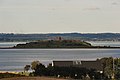
Kalø Vig and Kalø Castle ruins as seen from Egå Kirke ( Egå Church ).

The hunting lodge and manor house Kalø Hovedgård on Kalø Vig.


