Kalahandi (District)
| Kalahandi District କଳାହାଣ୍ଡି ଜିଲ୍ଲା |
|
|---|---|

|
|
| State | Odisha |
| Division : | South Division |
| Administrative headquarters : | Bhawanipatna |
| Area : | 7920 km² |
| Residents : | 1,576,869 (2001) |
| Population density : | 199 inhabitants / km² |
| Website : | kalahandi.nic.in |
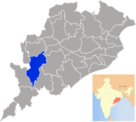
The Kalahandi District ( Oriya କଳାହାଣ୍ଡି ଜିଲ୍ଲା Kaḷāhāṇḍi Jillā ) is located in the west of the Indian state of Odisha . The administrative seat is the city of Bhawanipatna .
location
The district extends over an area of 7,920 km² in the Eastern Ghats . The Tel River flows through the northwestern part of the district as well as along the border with Balangir District .
Residents
In the 2011 census, the population was 1,576,869. The gender ratio was 1003 women for 1000 men. The literacy rate was 59.22% (71.90% for men, 46.68% for women). 98.64% of the population were followers of Hinduism .
Administrative division
The district consists of 2 sub-divisions : Bhawanipatna and Dharmagarh.
To decentralize the administration, the district is divided into 13 blocks :
- Bhawanipatna
- Dharmagarh
- Golamunda
- Jaipatna
- Junagarh
- Kalampur
- Karlamunda
- Kesinga
- Koksara
- Lanjigarh
- Madanpur Rampur
- Narla
- Thuamul Rampur
There are also 9 Tahasils : The district has the following ULBs : the Municipality Bhawanipatna and the three Notified Area Councils (NAC) Dharmagarh , Junagarh and Kesinga . There are also 272 gram panchayats in the district.
