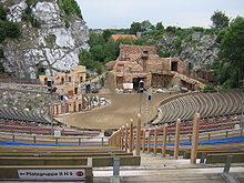
Kalkberg Stadium

The Kalkbergstadion is an open-air stage in the center of Bad Segeberg , where the Karl May Games have been held every year since 1952 .
history
The prerequisites for the creation of this amphitheater , which is oversized for a small town like Bad Segeberg, were given by the pit that had been created by the centuries of gypsum mining on the Segeberger Kalkberg . In the 60s and 70s of the 19th century, attempts were made several times to develop the salt masses stored under the anhydrite of the gypsum mountain. Boreholes had found what they were looking for, but the shafts that were driven down for the purpose of mining were repeatedly full of water, which could not be mastered even with the help of large steam pumps.
In 1931 the quarrying of gypsum ended.
After the seizure of power of the Nazis , the unsightly open pit has been transformed into a place for mass gatherings and first for Nazi Thing games used. According to plans by the government master builder Fritz Schaller (then Berlin), who took up plans by the garden and landscape designer Wilhelm Heintz from 1927, from May 29, 1934, volunteers from the National Socialist Labor Service (NSAD) and from 1935 onwards from the Reich Labor Service ( Reichsarbeitsdienst) erected what was initially called the " Thingstätte " Stadium designed by the architect Fritz Schaller.
For the visitor stands, further segments were broken out of the rock and amphietheatrical steps were piled up, the old salt shafts and caves were filled and the remains of a pump house were demolished. Most recently, a local civil engineering company processed over a thousand tons of optically similar Silesian granite into the spectator stands, as the water-soluble anhydrite of the mountain was not suitable for construction. On October 10, 1937, the stadium was opened under the name "Feierstätte der Nordmark" by Joseph Goebbels and with the performance of the play The Battle of the White Ships by Henrik Herse in front of a large audience. The newsreel reports 20,000 cheering viewers who came to the opening. The Kalkbergstadion is one of the many thing places that were built for the thing game or the thing movement (including the Berlin Waldbühne ). Even during the Second World War , the stadium was used for National Socialist mass rallies. B. the Hitler Youth (HJ) and in 1944 the Association of German Girls (BDM).
On May 3, 1945 Bad Segeberg was occupied by British soldiers without a fight. On the day of the unconditional surrender of the Wehrmacht on May 8, the British soldiers celebrated the end of the Second World War in Bad Segeberg in the Kalkberg Stadium. After the war, for example, the Brumbach Circus also performed in Kalkbergrund . The city was unsure what to do with this legacy from the Nazi era until a solution was found in 1952 with the Karl May Games , which proved its worth. But open-air concerts also take place there.
TV
- 2017: NDR documentation; When Winnetou came north. (Broadcast on July 5, 2017, NDR 8.15–9.45 p.m.)
Web links
Individual evidence
- ^ Society for Schleswig-Holstein History - Kalkbergstadion
- ↑ a b c Katharina Bosse: Bad Segeberg D Info. In: Thingstaetten. May 11, 2020, accessed on June 19, 2020 (German).
- ↑ From Goebbels to Winnetou: Das Kalkbergstadion , from: July 5, 2017; Retrieved on: July 8, 2017
- ^ Lübecker Nachrichten : Bad Segeberg Lecture about the end of the war , from: December 8th, 2015; Retrieved on: July 8, 2017
- ^ Lübecker Nachrichten : Bad Segeberg Lecture about the end of the war , from: December 8th, 2015; Retrieved on: July 8, 2017
- ↑ From Goebbels to Winnetou: Das Kalkbergstadion , from: July 5, 2017; Retrieved on: July 8, 2017
Coordinates: 53 ° 56 ′ 8 ″ N , 10 ° 19 ′ 4 ″ E
