
Cape Dezhnev
Coordinates: 66 ° 4 ′ 45 ″ N , 169 ° 39 ′ 7 ″ W.


The Cape Deschnjow (alternative spelling Cape Deschnjew or Cape Deschnew , Russian Мыс Дежнёва Mys Deschnjowa , after the Russian seafarer and fur hunter Semyon Deschnjow , who circumnavigated it in 1648 as the first European) is the most easterly point of the Russian and thus also the Asian mainland ( Ratmanov Island , which belongs to Russia, lies further east).
geography
It is located on the Chukchi Peninsula on the Bering Strait , which connects the Chukchi Sea ( Arctic Ocean ) and the Bering Sea (North Pacific ). The US Cape Prince of Wales lies in the east at a distance of 82 km from the Russian Cape Deschnjow . In between are the Diomedes Islands . The global date line runs in a north-south direction through the Bering Strait, which separates eastern Siberia from Alaska , thus separating Russia from the USA and thus Asia from America .
The distance to Cape Baba in Anatolia ( Turkey ), the westernmost point of the Asian mainland on the Aegean coast , is 8,223 km. The Asian mainland has the largest extension with 10,940 km between Cape Chaplin (Мыс Чаплина) and Ra's Bab al-Mandab in Yemen .
gallery

Cape Deschnjow:
lighthouse with Deschnjow monument (66 ° 4'45 "N, 169 ° 39'7" W)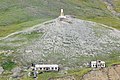
Cape Deschnjow
with lighthouse (Deschnjow-Monument) and abandoned settlement Naukan
Cape Dezhnev

Cape Dezhnev

Cape Deschnjow:
relic of the abandoned settlement Naukan
Erect whale bones near Naukan


Others
The area was the starting point of Clemens Forell's escape in the novel As Far as Your Feet Carries.
See also
Web links
Individual evidence
- ↑ Calculation with freemaptools