Kasserine
| Kasserine |
||
|---|---|---|
| administration | ||
| Country |
|
|
| Governorate | Kasserine | |
| Délégation (s) | Kasserine north + south | |
| Post Code | 1200 | |
| Website | Kasserine | |
| Demographics | ||
| population | 86,975 pop (2014) | |
| geography | ||
| height | 655 m | |
|
|
||
| Coordinates | 35 ° 10 ′ N , 8 ° 50 ′ E | |
Kasserine ( Arabic القصرين, DMG al-Qaṣrain ) is a former three districts ("arrondissement": Kasserine, Cité Ennour and Ezzouhour) in the center of Tunisia , which is in two different delegations ( Kasserine Nord and Kasserine Sud ). It is the capital of the Kasserine governorate of the same name and has around 90,000 inhabitants.
location
Kasserine is about 300 km (driving distance) southwest of the state capital Tunis and about 55 km from the Algerian border at Bou Chebka . The city is surrounded by three mountain ranges ( Djebel Chambi 1544 m, Djebel Semmama 1314 m, Djebel Selloum 1373 m) and lies on the year-round water-bearing Oued Derb . The low rain climate in Kasserine is rather moderate due to the altitude of 655 m.
population
In the year of Tunisia's independence (1956), the city of Kasserine had about 3,000 inhabitants; Another 12,000 people lived in the surrounding area. Most of the population who then immigrated from the surrounding regions is of Berber descent, but the colloquial language is Arabic .
economy
The city's most important industrial company is the Société nationale de cellulose et de papier alfa (SNCPA), a company that produces pulp from half-grass with around 800 employees; Around 40,000 tons of half-grass are cut every year in the area around the city, from which about 12,000 tons of paper are made. There is also a factory for the production of hollow blocks , a beverage bottling plant and an oil mill.
history
The Roman Cilium originated around 80 AD at the time of Emperor Vespasian and was inhabited until the Byzantine period . The remains of the Kasserine Dam , the largest Roman gravity dam in North Africa, are located near the city on the Oued Derb . In 544 the Byzantine general Solomon was killed against a Moorish coalition army at the Battle of Cilium . In the middle of the 7th century the area of what is now Tunisia and the Algerian East ( Ifrīqiya ) was conquered by the advancing Islamic armies; the Cilium , renamed Kasrin , then disappeared from the chronicles for a long time.
The region around Kasserine was the scene of one of the most famous battles of the African campaign during World War II (February 1943) . (→ Battle of the Kasserin Pass ).
During the revolution in Tunisia in 2010/2011 , the city was the scene of particularly violent clashes between protesters and security forces, with special government forces shooting dozens of people.
Attractions
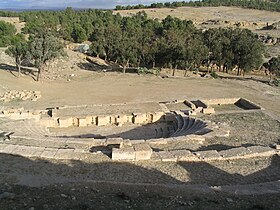
- North-east of the city is the ancient city of Cilium . The most important buildings of the ruins are a single-arched triumphal arch in honor of the emperor Septimius Severus , a theater and the forum ; the foundations of an early Christian church were also identified. In addition, you can see the sparse ruins of what was originally supposed to be around 10 m high and 150 m long ancient dam, the Kasserine Dam .
- Nearby is a waterfall of the Oued Derb that can only be seen after heavy or prolonged rainfall.
Personalities
- Esma Abdelhamid (* 1960), author
- Karim Haggui (* 1984), soccer player
Web links
- Kasserine - photos + information
- Kasserine - Photos and brief information (English)
- Casserole, Oil Harvesting and Processing - Video (Arabic)
- Kasserine, five years after the Tunisian revolution - newspaper article with photos
Individual evidence
- ↑ Kasserine Nord - 2014 census
- ↑ Kasserine Sud - 2014 census
- ↑ Page 156, Statistiques Tunisie, Classification Nationale des Unités Administratives Code géographique Tunisien , December 2012 PDF . By decree of December 2015, Cité Ennour and Ezzouhour became independent municipalities (see pages 2986–2989 in the Journal Officiel de la République Tunisienne , December 15, 2015 PDF )
- ↑ Kasserine and surroundings - climate tables


