Kilverbach
|
Kilverbach (rare: Kollbach) |
||
|
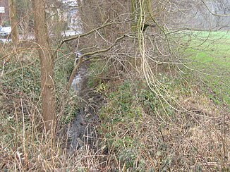
The Kilverbach in the upper reaches near Rödinghausen |
||
| Data | ||
| Water code | DE : 46654 | |
| location | North Rhine-Westphalia / Lower Saxony , Germany | |
| River system | Weser | |
| source | In Rödinghausen 52 ° 15 ′ 20 ″ N , 8 ° 28 ′ 39 ″ E |
|
| Source height | 148 m above sea level NN | |
| muzzle | For Bruchmühlen in the Else coordinates: 52 ° 12 ′ 3 ″ N , 8 ° 27 ′ 10 ″ E 52 ° 12 ′ 3 ″ N , 8 ° 27 ′ 10 ″ E |
|
| Mouth height | 66 m above sea level NN | |
| Height difference | 82 m | |
| Bottom slope | 9.7 ‰ | |
| length | 8.4 km | |
| Catchment area | 16.09 km² | |
| Left tributaries | Kollbach | |
| Right tributaries | Kilverbach (tributary of the same name) | |
| Medium-sized cities | Melle | |
| Communities | Rödinghausen | |
The Kilverbach (or more rarely Kollbach ) is an 8.4 km long, left tributary of the Else in the northeast of the German state North Rhine-Westphalia and in the south of Lower Saxony .
The alternative, but rather uncommon name Kollbach officially only refers to a left tributary that flows into the Kilverbach at Bach kilometer 7.4. The Kilverbach represents the border between Rödinghausen and Melle or North Rhine-Westphalia and Lower Saxony for about 7 km . The brook rises near the center of Rödinghausen on the slopes of the Wiehengebirge and then flows south through the Kilverbachtal. The source height is 149 m. At brook kilometer 6.4 a tributary of the same name flows into the Kilverbach on the right. After a river length of 8.4 kilometers, the Kilverbach drains into Bruchmühlen into the Else (Else kilometers 19.5). The mouth height is around 68 m. Numerous tributaries belong to the stream system. So he overcomes about 81 meters in altitude. The Kilverbachtal and the floodplains of the tributaries form an extensive sieve system with near-natural upper and middle courses.
Flora and fauna
The floodplains are often preserved as wet or wet grassland and are mostly covered with alders . Field trees dominated by red beech grow on the relatively steep slopes of the box-shaped Sieke, and beeches in the upper reaches . Originally the stream ran in the middle of the valley, but when the Sieken was created it was relocated to the side of the embankment to make better use of the area. Endangered plant and animal species can be found in the Kilverbachtal. In spring, for example, meadowfoam , buttercup and cuckoo carnation grow on the wet meadows . Butterflies like the aurora butterfly or the blood droplet have their habitat in the valley and even the colorful kingfisher fishes in Kilverbach.
In a largely agricultural use of the surrounding area, the stream system represents a valuable biotope, which is also typical of the cultural landscape of the Ravensberger Land and the Ravensberger Mulde with its Siektäler valleys. Therefore, the state of North Rhine-Westphalia and the administrative district of Detmold have designated the area as a nature reserve and thus connected to the FFH area System Else / Werre . Of 6 nature reserves in the municipality of Rödinghausen with a total area of 189 hectares , the Kilverbachtal nature reserve is by far the largest with 107 hectares. On the Lower Saxony side, the Kilverbachtal is designated as a landscape protection area.
In the upper reaches both sides standing characterize Kopfweiden the landscape.
history
The Kilverbach marked the border between France and the Kingdom of Westphalia between 1807 and 1811 , and was the state border between the Kingdom of Hanover and the Principality of Osnabrück and Prussia for a long time before and after .
Individual evidence
- ↑ a b German basic map 1: 5000
- ↑ a b Topographical Information Management, Cologne District Government, Department GEObasis NRW ( Notes )


