Kingston Bridge
Coordinates: 51 ° 24 ′ 40 " N , 0 ° 18 ′ 32" W.
| Kingston Bridge | ||
|---|---|---|
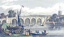
| Kingston Bridge as seen from the south | ||
| use | Road bridge | |
| Convicted | Main road |
|
| Subjugated | Thames | |
| place | London | |
| construction | Arch bridge | |
| Number of openings | 3 | |
| vehicles per day | 50,000 vehicles / day | |
| location | ||
|
|
||
The Kingston Bridge is a road bridge over the River Thames in London , close to the mouth of the river Hogsmill . It connects the district of Kingston in the district of Royal Borough of Kingston upon Thames on the east side with the district of Hampton Wick and Bushy Park in the district of London Borough of Richmond upon Thames on the west side. It is located on the route of the A308 main road and is passed by over 50,000 vehicles every day.
history
There is evidence that there was a wooden bridge here as early as the 13th century. Until the Putney Bridge was built in 1729, it was the only river crossing between London Bridge and Staines Bridge . This led to Kingston becoming a major market town.
In 1828 the first brick bridge was built. It was made of Portland stone and had five elliptical arches with tower-like abutments and a balustrade . It was 327 feet (99.67 m) long and 27 feet (8.23 m) wide. Lord Liverpool laid the foundation stone on November 7, 1825, and opened on July 17, 1828. The toll was lifted in 1870. The first widening took place in 1914, and the bridge was widened again in 2000.
Web links
|
upstream Hampton Court Bridge |
River crossings of the Thames |
downstream Kingston Railway Bridge |


