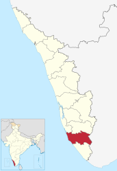
Kollam (District)
| Kollam District | |
|---|---|

|
|
| State | Kerala |
| Administrative headquarters : | Kollam |
| Area : | 2,483 km² |
| Residents : | 2,629,703 (2011) |
| Population density : | 1,061 inhabitants / km² |
| Website : | kollam.gov.in |
The Kollam District ( Malayalam : കൊല്ലം ജില്ല ; formerly: Quilon ) is a district in the southern Indian state of Kerala . The administrative seat is the eponymous city of Kollam . The Kollam district has an area of 2,483 square kilometers and around 2.6 million inhabitants (2011 census).
geography
The Kollam District is located in southern Kerala. It borders on the Thiruvananthapuram district to the south, the neighboring state of Tamil Nadu ( Tirunelveli district ) to the east and the Pathanamthitta and Alappuzha districts to the north . To the west lies the coast of the Arabian Sea .
The Kollam District has an area of 2,483 square kilometers. The district area stretches from the sea coast to the mountains of the Western Ghats , which form the natural border with the neighboring state of Tamil Nadu in the east. In the hinterland of the coast are the backwaters , an extensive network of canals, rivers and lagoons. This water system includes the extensive Ashtamudi Lake north of the district capital Kollam and the Paravur Lake near Paravur in the south of the district. The district area is traversed by the Kallada and Ithikara rivers.
There is a tropical monsoon climate in the Kollam district . The annual mean temperature in Kollam is 27.0 ° C, the annual mean precipitation is 2468 mm. Most rainfall occurs during the southwest monsoon between June and September.
history
The district capital of Kollam is a historic port city, where merchant ships from Rome and China already called in in ancient times and the Middle Ages . During the British colonial period , the area of today's district belonged to the princely state of Travancore . After Indian independence, the latter united with Cochin to form the Travancore-Cochin Federation, and in 1949 joined the Indian Union. In 1956, the Kollam district became one of the districts of the newly established state of Kerala by merging Travancore-Cochin and the Malabar district of the state of Madras . A year later, the Alappuzha District was split off from the Kollam District. In 1982 the Pathanamthitta district was created from parts of the Kollam, Alappuzha and Idukki districts .
population

According to the 2011 Indian census, the Kollam district has 2,635,375 inhabitants. The population density of 1,061 inhabitants per square kilometer is still higher than the already high average of Kerala (860 inhabitants per square kilometer). 45 percent of the district's residents live in cities. The degree of urbanization is thus slightly lower than the mean value for the state (48 percent). Thirteen percent of the district's residents are scheduled castes . At 94 percent, the literacy rate corresponds to the average in Kerala.
According to the 2011 census , Hindus make up the majority of the residents of the Kollam district with 64 percent. There are also larger minorities of Muslims (19 percent) and Christians (16 percent). The Hindu population is lower than the average in India, but higher than in most other areas of the religiously mixed state of Kerala.
The main language in the Kollam district, as in all of Kerala, is Malayalam . According to the 2001 census, 99 percent of the district's residents speak it as their first language.
Administrative division
The Kollam District is divided into five taluks :
| Taluk | main place | Population (2011) |
|---|---|---|
| Karunagapally | Karunagapally | 428,802 |
| Kollam | Kollam | 987.779 |
| Kottarakkara | Kottarakkara | 586.434 |
| Kunnathur | Sashtamkotta | 199,456 |
| Pathanapuram | Punalur | 432.904 |
Cities
| city | Population (2011) |
|---|---|
| Adichanalloor | 27,240 |
| Adinad | 22,250 |
| Ayanivelikulangara | 24,268 |
| Chavara | 42,655 |
| Elampalloor | 33,959 |
| Kallelibhagom | 21,723 |
| Karunagapally | 25,336 |
| Kollam | 348,657 |
| Kottamkara | 44,402 |
| Kottarakkara | 29,788 |
| Kulasekharapuram | 26,907 |
| Mayyanad | 40,039 |
| Meenad | 29,716 |
| Nedumpana | 29,454 |
| Oachira | 28,412 |
| Panayam | 25,607 |
| Panmana | 29,008 |
| Paravoor | 37,245 |
| Perinad | 35.173 |
| Poothakkulam | 29,447 |
| Punalur | 46,702 |
| Thazhuthala | 37,517 |
| Thodiyoor | 25,884 |
| Thrikkadavoor | 39,285 |
| Thrikkaruva | 25,432 |
| Thrikkovilvattom | 41,609 |
| Vadakkumthala | 20,993 |
Individual evidence
- ↑ Census of India 2011: Primary Census Abstract - Kerala. (PDF; 522 kB)
- ↑ Climate data from climate-data.org .
- ^ Census of India 2011: Primary Census Data Highlights - Kerala. Chapter - I Population, Size and Decadal Change.
- ^ Census of India 2011: Primary Census Data Highlights - Kerala. Chapter - II Scheduled Castes and Scheduled Tribes Population.
- ^ Census of India 2011: Primary Census Data Highlights - Kerala. Chapter - III Literates and Literacy Rate.
- ^ Census of India 2011: C-1 Population By Religious Community. Kerala.
- ↑ Census of India 2001: C-15: Population by Mother Tongue (Kerala), accessed under Tabulations Plan of Census Year - 2001 .
- ↑ a b Census of India 2011: Primary Census Abstract Data Tables: Kollam.

