Cordillera of Cochabamba
| Cordillera of Cochabamba | ||
|---|---|---|
|
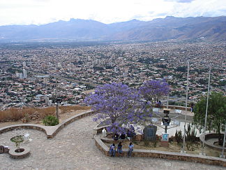
South break of the cordillera to the basin of Cochabamba |
||
| Highest peak | Cerro Tunari ( 5035 m ) | |
| location | Bolivia | |
| part of | To the | |
|
|
||
| Coordinates | 17 ° 17 ′ S , 66 ° 22 ′ W | |
The Cordillera of Cochabamba (Spanish Cordillera de Cochabamba ) or Cordillera de la Herradura ("horseshoe mountain range") is a mountain range in the eastern parts of the Bolivian Andes .
The Cordillera of Cochabamba is an eastern continuation of the Cordillera Real and separates the humid plains of the Yungas in the Amazon basin in the east from the valleys and basins with a temperate climate, which lie in the transition area to the Altiplano plateau surrounded by high mountain ranges . The Cordillera is largely located in the Cochabamba department east of Cochabamba , the third largest city in Bolivia.
The Cordillera extends within the department over an area of around 3000 km² in an arc from west to south-east. The highest peak of the Cordillera is Cerro Tunari with a height of 5035 m , which is embedded in the Tunari National Park . The species-rich fauna of the Cordillera includes condor , vicuña , lama , alpaca and vizcacha .
The Cochabamba cordillera has its source in important Bolivian rivers such as the Santa Elena and Río Catacajes in the west, the Río Caine and Río Grande in the south, and the Río Chapare and Río Ichilo in the east.

