Koschuta
| Koschuta (Košuta) | ||
|---|---|---|
|
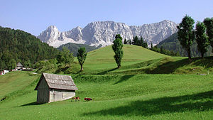
Koschuta with Koschutnikturm as seen from Zell-Pfarre (Sele-Fara). |
||
| height | 2136 m above sea level A. ( 2133.4 m. Y. Y. ) | |
| location | Carinthia , Austria and Slovenia | |
| Mountains | Karawanken , Karawanken and Bacher Mountains | |
| Dominance | 9 km → Hochobir | |
| Notch height | 768 m ↓ Loiblpass | |
| Coordinates | 46 ° 26 '46 " N , 14 ° 24' 36" E | |
|
|
||
| rock | Dachstein Limestone | |
The Koschuta ( Slovenian : Košuta ) is a 14 km long mountain range ( mountain massif ) in the Karawanken , south of Klagenfurt . Its ridge extends in a west-east direction; The border between Austria and Slovenia runs over almost its entire length .
Location and character
The northern flank of the Koschuta, which belongs to the federal state of Carinthia, is almost completely characterized by several hundred meter high rockfalls. The Slovenian southern flank, on the other hand, is much gentler; partly grass slopes reach up to the border ridge.
The highest peak is the striking Koschutnikturm / Košutnikov turn ( 2136 m above sea level ); the majority of the named elevations in the ridge reach a height of over 2,000 meters.
A marked trail runs over most of the ridge from the Hochturm / Veliki vrh in the far west to the Koschutnikturm. It sometimes deviates a little into the Slovenian southern flank and has some insured sections, maximum difficulty level B. The eastern part of the border ridge between the Koschutnikturm and the Dicken Koschuta / Tolsta Košuta , on the other hand, is much more exposed. Here some passages require climbing in the III. Level of difficulty.
bases
The most important base on the Austrian side is the Koschutahaus der Naturfreunde at 1279 m above sea level. A. It is open all day in summer and on Saturdays, Sundays and public holidays in winter and offers beds for 55 people (34 in rooms, 21 in the warehouse).
There are several alpine pastures on the Slovenian south side and the Dom na Kofcah of the Slovenian Alpine Association near the western end of the ridge .
Insured climb to the ridge
Three via ferratas of varying degrees of difficulty lead through the rocky north flank of Koschuta.
- The climb from Hajnžsattel to the high tower in the west of the ridge runs near the state border between Austria and Slovenia. It reaches a maximum of difficulty level B. However, a channel secured with a wire rope and step pins has brittle rock.
Two more climbs are best reached from the Koschutahaus:
- The short ÖTK climb to the Koschutnikturm leads to the saddle west of the summit. It was re-routed from 2006 and now has an optional rope bridge. The new route is less prone to falling rocks than the old one, but it is technically more demanding (up to difficulty level C).
- The 700 meter long Lärchenturm via ferrata was opened in 2006 . It has sections up to difficulty level D; walking it requires all-round alpine skills. Usually, the ascent to Lärchenberg / Užnik at the state border takes place from the Lärchenturm ; the descent then takes place via the Grenzsteig and the ÖTK-Steig.
literature
- Manfred Posch: The magic kingdom of Karawanken. The most beautiful tours . Klagenfurt 1997, Carinthian Printing and Publishing Company, ISBN 3-85391-143-9
Web links
- Entry on Koschuta in the Austria Forum (in the AEIOU Austria Lexicon )
- Koschutnikturm - Hribi.net
- Description of the Lärchenturm via ferrata at www.bergstieg.com


