Kouvola
| coat of arms | map |
|---|---|
|
|
| Basic data | |
| State : |
|
| Landscape : | Kymenlaakso |
| Administrative community : | Kouvola |
| Geographical location | 60 ° 52 ′ N , 26 ° 42 ′ E |
| Surface: | 2,883.32 km² |
| of which land area: | 2,558.09 km² |
| of which inland waterways: | 325.23 km² |
| Residents : | 83,177 (Dec. 31, 2018) |
| Population density : | 32.5 inhabitants / km² |
| Municipality number : | 286 |
| Postcodes : | 45100-47910 |
| Language (s) : | Finnish |
| Website : | kouvola.fi |
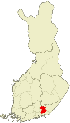
Kouvola [ ˈkɔu̯vɔlɑ ] is a city in southern Finland . Located on the Kymijoki River , the city is the administrative seat of the Kymenlaakso countryside and an important railway junction . In addition to the actual city, Kouvola administratively includes an extensive area of over 2,800 square kilometers in the surrounding area. Kouvola has a total of 83,177 inhabitants (as of December 31, 2018), a good third of whom live in the city center.
geography
The core city of Kouvola is located in the north of the Kymenlaakso countryside, 134 kilometers northeast of the capital Helsinki . In addition, since a large municipal merger at the beginning of 2009, the administrative city area has included an extensive area in the surrounding area with a total area of 2,885 km² (slightly more than Luxembourg). This area is largely structured in a rural way with individual settlement centers in between ( taajama ) . The most important settlement centers besides the core city are the industrial areas Kuusankoski , Myllykoski , Inkeroinen and Anjala .
The Salpausselkä ridge divides the Kouvola area into a northern part, rich in lakes and heavily forested, and a southern part, which is poor in inland water and is used more intensively for agriculture. The area is crossed by the Kymijoki , one of the largest rivers in southern Finland.
Neighboring communities of Kouvola are Mäntyharju in the north, Savitaipale in the northeast, Luumäki in the east, Hamina in the southeast, Kotka in the south, Loviisa and Lapinjärvi in the southwest, Iitti in the west and Heinola in the northwest.
history
The area of Kouvola, the northern Kymenlaakso, historically belongs to the border area of the Uusimaa and Karelia landscapes . In the Treaty of Åbo in 1743, the area was divided between Sweden and Russia along the course of the Kymijoki . In 1809 the entire area of today's Finland finally came to Russia and became the Grand Duchy of Finland .
The place Kouvola has been occupied since the 15th century; until the 19th century it was an insignificant village in the parish of Valkeala . The upswing of Kouvola began after the place received a stop on the railway line from Riihimäki to Saint Petersburg in 1875 . Within the next two decades, more rail lines to the north in the direction of Kuopio and south in the direction of Kotka were completed, so that Kouvola became a railway junction and soon grew into a populous place. In the course of industrialization at the end of the 19th century, several paper mills were built on the Kymijoki rapids in the Kouvola area. Kymin osakeyhtiö joint stock company was founded in Kuusankoski in 1872 . From this emerged the Kymmene group, which in 1996 was again merged into UPM-Kymmene , one of the world's largest forest and paper groups.
In 1922 Kouvola was detached from the municipality of Valkeala. A year later, the place was raised to a market town (kauppala) . Kouvola received its town charter in 1960. From 1955 until the provincial reform of 1997, Kouvola was the capital of the Kymi Province . As part of the ongoing restructuring of the Finnish municipalities, a large municipal merger took place at the beginning of 2009, in which the cities of Anjalankoski and Kuusankoski and the municipalities of Valkeala , Jaala and Elimäki with Kouvola merged. This tripled the population of Kouvola; the area increased more than sixty times.
politics
administration
The strongest political force in Kouvola is the Social Democratic Party , which traditionally enjoys strong support, especially in industrial areas. In the 2008 local elections she received around a quarter of the vote; in the city council, the highest decision-making body in local affairs, it has 20 out of 75 deputies. In second place is the conservative rallying party with 17 seats on the city council. The country's third major party, the Center Party , which has its electorate mainly in rural Finland, has thirteen seats. Also represented in the city council are the independent electoral list Kouvolan Seudun Sitoutumattomien yhteislista with ten, the Christian Democrats and right-wing populist base fins with five each, the left alliance with three and the Green Bund with two members.
| Political party | Election result | Seats |
|---|---|---|
| Social democrats | 25.7% | 20th |
| Collection party | 22.0% | 17th |
| center | 17.7% | 13 |
| Independent | 12.7% | 10 |
| Christian Democrats | 7.2% | 5 |
| Base fins | 6.8% | 5 |
| Left alliance | 4.0% | 3 |
| Green covenant | 3.7% | 2 |
coat of arms
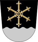
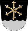
The city of Kouvola adopted a new coat of arms after the parish merger in 2009, designed by the artist Tapani Talari. It shows a gold six-spoke glaive wheel in black over a silver shield base with a wavy cut . The six spokes symbolize the six parishes that went up in Kouvola, while the glaives stand for the iris , the landscape flower of Kymenlaakso. The waves indicate the Kymijoki River. Black and silver are the heraldic colors of the Kymenlaakso landscape.
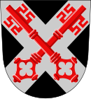
Before the municipal merger, Kouvola had a coat of arms drawn by heraldist Gustaf von Numers from 1952 to 2008 . It showed a silver cross in black with two crossed keys in red.
Town twinning
Since 2009, Kouvola has had town twinning with Balatonfüred in Hungary, Mülheim an der Ruhr in Germany and Vologda in Russia. The other town twinning, which the municipalities in Kouvola had maintained, ended at the end of 2008, as the former municipalities no longer exist legally due to the municipality merger.
traffic
Kouvola is an important railway junction. From here rail lines run in four directions: via Lahti to Helsinki and Riihimäki , to Kotka , to Mikkeli and from there on to Pieksämäki and Luumäki , where one line leads to Joensuu and one to Russia via the border town of Vainikkala . The capital Helsinki can be reached in under an hour and a half. The trains stop at the “travel center” of Kouvola, a combined bus and train station.
State roads 6 from Pernå to Kajaani and 15 from Kotka to Mikkeli also pass through Kouvola . In addition, Kouvola is the end of the state road 12 coming from Rauma .
Culture and sights
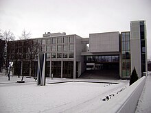
Kouvola is a rather faceless city, which is characterized by functional buildings from the 1970s. Some valuable architectural monuments can be found outside the city center: In the village of Verla there is a cardboard factory founded in 1882, which was converted into an industrial museum in 1964. In 1996 the factory complex was added to the UNESCO list of world cultural heritage as an outstanding example of industrial architecture of the 19th century . The Anjala and Sippola manors are also worth seeing . In the north of the urban area of Kouvola lies part of the Repovesi National Park .
The modern central church of Kouvola was completed in 1977. The Orthodox Holy Cross Church dates from 1915, is built in the Russian-Byzantine style and originally served as a garrison church for Russian soldiers. After Finnish independence , it was converted into an Evangelical Lutheran church, but with the completion of the central church it was returned to the Orthodox believers. In the core town of Kouvola there are also the Church of Käpylä (1952) and the Roman Catholic St. Ursula Church (1993). Among the churches in the other places in the city, the Elimäki Church, built in 1638 and converted into a cruciform church in 1678, is the oldest. The church of Anjala, built in 1755–56, is also a wooden cruciform church. The wooden church of Jaala (1878) and the brick church of Sippola (1879) represent the neo-Gothic style . The churches of Inkeroinen (1910), Voikkaa (1925), Valkeala (1927), Kuusankoski (1929), Myllykoski (1936) and Koria (1951) as well as the Orthodox chapel of Myllykoski (1954) date from the 20th century.
Sports
The town of Myllykoski, which belongs to Kouvola, is the home of the soccer club Myllykosken Pallo -47 (MyPa), which won the championship title in the Finnish Veikkausliiga in 2005. In addition, the Pesäpallo association Kouvolan Pallonlyöjät (KPL) and the ice hockey club KooKoo , which plays in the Liiga , the highest Finnish ice hockey league , come from Kouvola .
The normal ski jumping hill Palomänen Hyppyrimäki is in Kouvola . Kouvola hosted the 1982 European Under-18 Football Championship . In 1997 the European wrestling championship took place in the city . Twice, on July 18, 1937 and September 1, 1949, the world record in the 10,000-meter run was run in Kouvola .
sons and daughters of the town
- Juhani Aaltonen (* 1935), jazz musician
- Arto Bryggare (* 1958), hurdle sprinter
- Niilo Halonen (* 1940), former ski jumper
- Tommi Nikunen (* 1973), ski jumping trainer
- Toni Gardemeister (* 1975), rally driver
- Ville Nousiainen (* 1983), cross-country skier
- Sami Kaartinen (* 1979), ice hockey player
- Ari Koivunen (* 1984), singer and talent show winner
- Hannu Salama (* 1936), writer
- Niki Sirén (* 1976), ice hockey player
Individual evidence
- ↑ Maanmittauslaitos (Finnish land surveying office): Suomen pinta-alat kunnittain January 1, 2010 . (PDF; 199 kB)
- ↑ Statistical Office Finland: Table 11ra - Key figures on population by region, 1990-2018
- ↑ Finnish Ministry of Justice: Result of the 2008 local elections
- ↑ Website of the city of Kouvola: Vaakuna ja markkinointitunnus ( Memento from November 9, 2009 in the Internet Archive ) (Finnish)
- ^ Website of the city of Kouvola: Tunnus ja vaakuna . Retrieved July 15, 2019.
- ^ Website of the city of Kouvola: Ystävyyskaupunkitoiminta ( Memento of November 8, 2011 in the Internet Archive ) (Finnish).
- ^ Website of the city of Kouvola: International Kouvola . Retrieved July 15, 2019.
Web links
- City of Kouvola (English)


