Cake topping
| Cake topping | ||
|---|---|---|
|
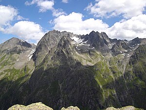
Kuchenspitze (left above the glacier) from the west |
||
| height | 3148 m above sea level A. | |
| location | Tyrol , Austria | |
| Mountains | Verwall group | |
| Dominance | 13 km → High Riffler | |
| Notch height | 578 m ↓ Lattejoch | |
| Coordinates | 47 ° 2 '54 " N , 10 ° 13' 48" E | |
|
|
||
| First ascent | September 3, 1877 by Andreas Madlener and Julius Volland | |
The Kuchenspitze is a 3148 m above sea level. A. high mountain in Verwall between Stanzer Tal and Paznaun in the west of North Tyrol .
Location and landscape
The mountain rises south of St. Anton am Arlberg . To the northeast of the summit is the Darmstädter Hut .
The Kuchenspitze is the second highest peak in the group after the Hohen Riffler . The main peak with the Kote 3148 forms the southeastern end of the long summit ridge, to the northwest are some secondary peaks of approximately the same height. The mountain is glaciated, in the Nordkar lies the Große Kuchenferner , in the west the Kleine Kuchenferner and to the south the Große Küchlferner . To the south of the ridge is the almost equally high Küchlspitze ( 3147 m ), over the Kuchenjöchl ( 2730 m ) the ridge continues northwards to the Scheibler ( 2978 m ). The Kuchenspitze is located a little north of the main ridge of the Verwall, which runs over the Küchlspitze. The entire east side drains to the Kartellspeicher and the Moosbach to the Rosanna , the west flank to the Fasulbach , which goes to the upper Rosanna.
Development and ascent
Two of the peaks, including the 3,148 meter high main summit, were first climbed by Andreas Madlener and Julius Volland on September 3, 1877. At the time, it was one of the few unclimbed peaks in the group, as the main ridge of the Verwall was climbed around 1860 for land surveying .
The mountain is very rarely climbed today. All climbs require mountaineering experience and climbing ability. Probably the simplest (but not necessarily the least dangerous) route leads from the Konstanzer Hütte (which can be reached from St. Anton through the Verwalltal , for example) through the Fasul valley and over a steep grass slope to the plateau southwest of the summit. The summit ascent then takes place over the Kleiner Kuchenferner and through a system of gutters in the southwest wall, through which one reaches the summit ridge a little northwest of the main summit (at least difficulty level UIAA II / SAC WS + ). From the Darmstädter Hütte in the upper Moostal region, the summit can also be reached via various routes of varying difficulty.
Darmstädter Hütte towards Kuchenjöchl, on the right the Scheibler , on the left the northern summit of the Kuchenspitze.
Küchlspitze (left) and Kuchenspitze (right) from the east. On the far right the Kuchenjoch (2730 m), above this the Zimba in the distance.
Individual evidence
- ↑ a b Peter Pindur, Roland Luzian, Andreas Weiskopf: 1770 Kuchenspitze 3148 m in Alpenvereinsführer Verwallgruppe 1988, p. 203 ff.
-
↑ Tour reports (chronological):
Kuchenspitze 3148m - north face (55 °, 4-) , Martin Rossmann and Peter Mayer on bg.gebirgsverein.at, 28/29. February 2003;
May 11-12, '07 Kuchenspitze north face , Zwerggäuer on rocksports.de, May 17, 2007;
Summit: Kuchenspitze, 3148 m above sea level , Hanspeter Willi in gipfelbuch.ch, September 4, 2011;
Kuchenspitze (3148 m) - rustic mountain for the adventurer , 83_Stefan on hikr.org, October 6, 2011;
Kuchenspitze 27. / 28.07.2013 , AV section Kleinwalsertal, alpenverein.at.


