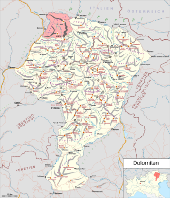
Luson mountains
| Luson mountains | |
|---|---|
|
Luson mountains shown in red on the Dolomite map |
|
|
The Plose |
|
| Highest peak | Gabler ( Plose ) ( 2576 m slm ) |
| location | South Tyrol , Italy |
| part of | Dolomites |
| Coordinates | 46 ° 43 ' N , 11 ° 46' E |
The Lüsner Mountains are a mountain group in the north-western Dolomites , which is located in South Tyrol ( Italy ). Geologically, although they are not made of dolomite but of quartz phyllite , they belong to the southern Alps , the basement of which they form together with the complex of the Etschtal volcanic group .
Location and surroundings
The Lüsner mountains are in the west of the Isarco Valley , to the north by Pusteria and to the east by the Val Badia limited. In the south they go over at the Würzjoch and Kofeljoch to the Peitlerkofel group , from which they are otherwise separated by the Aferer and the Untermoital .
The Lüsener Berge are mostly in the area of the municipalities Lüsen , Brixen , St. Martin in Thurn , Enneberg , St. Lorenzen , Kiens and Rodeneck .
structure
The Lüsner Valley , which leads from the Eisack Valley first to the east and then to the south, roughly divides the mountain group into two blocks. In the south-west lies the mostly grassed mountain of the Plose , where with the Großer Gabler ( 2576 m ) is the highest peak of the group. The other mountains of Lüsner consist of the long, relatively flat ridge of the Lüsner and Rodenecker Alm . Among the less prominent peaks there are the Maurerberg ( 2332 m ) in the southeast and the Astjoch ( 2196 m ) in the northeast.
literature
- Hanspaul Menara and Josef Rampold : South Tyrolean mountain tours . Athesia, Bozen 1976, p. 178 .
- GM Bargossi et al. a .: The Lower Permian Athesian Volcanic Group (AVG) in the Adige valley between Merano and Bolzano: a stratigraphic, petrographic and geochronological outline PDF file

