
La Graciosa
| La Graciosa | ||
|---|---|---|
 |
||
| Waters | Atlantic Ocean | |
| Archipelago | Chinijo Archipelago ( Canary Islands ) | |
| Geographical location | 29 ° 15 '6 " N , 13 ° 30' 29" W | |
|
||
| surface | 29.05 km² | |
| Highest elevation |
Las Agujas Grandes 266 msnm |
|
| Residents | 695 24 inhabitants / km² |
|
| main place | Caleta del Sebo | |
 |
||

La Graciosa is the smallest inhabited island of the politically Spain belonging to the Canary Islands in the Atlantic Ocean . Since November 2018 it has been recognized by the Statute of Autonomy as the eighth inhabited island of the Canaries.
history
The Norman navigator Jean de Béthencourt called the island the graceful one in 1402 .
Since 1986 La Graciosa has been part of the nature park of the Chinijo Archipelago north of Lanzarote .
La Graciosa is administered by the municipality of Teguise in Lanzarote .
Localities
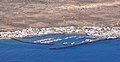
The main town of the island is Caleta del Sebo with 653 inhabitants (as of January 2011) who live mainly from tourism and fishing. In the east of the island there is a second place called Pedro Barba (also Casas de Pedro Barba ). This place consists exclusively of holiday homes of other Canary Islands residents, can only be reached by boat or on the slopes of Caleta del Sebo and is usually only inhabited in the summer months. Only a few local off-road vehicles are permitted on La Graciosa. There are no paved roads.
Caleta del Sebo, view from Lanzarote

Part of the port of Caleta del Sebo

Playa de Las Conchas
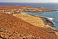
Pedro Barba from the west
Pedro Barba riverside path


geography
With 29.05 square kilometers, La Graciosa has an area share of 0.39 percent of the total area of all Canary Islands.
The Mediterranean-subtropical climate on La Graciosa is pleasant all year round, with temperatures of around 28 ° C in summer. Stormy winds and rain can be expected in the winter months and temperatures can drop to around 15 ° C at night. During the day it remains mild at 20 ° C to 25 ° C. There are no fresh water sources on the island, so the drinking water has to be brought in by pipeline under the Río, the strait between La Graciosa and Lanzarote, which is just over a kilometer wide, or by tanker.
Ice herb ( Mesembryanthemum cristallinum , Spanish Barilla ), shrub lettuce (Launaea arborescens) and other gray-green plants thrive on the barren island . The only roads are sand tracks. The highest peaks are Las Agujas Grandes (266 m) and Las Agujas Chicas (257 m) in the middle of the island. In the north is the Montaña Bermeja at 157 meters and at the foot of the 600 meter long white sandy beach Playa de Las Conchas with dangerous currents. Playa Lambra beach is about two kilometers further . In southwest of yellow and red is tuffs built Montaña Amarilla . At 172 meters high, it is partially cut off by the sea. At its foot are the two small but bathing beaches, Playa de la Cocina and Playa Francesa . Near Caleta del Sebo, in the interior of the island, is the Montaña del Mojon with a height of 188 meters and a crater about 70 meters deep.

literature
- Richard Pott , Joachim Hüppe, Wolfredo Wildpret de la Torre: The Canary Islands. Natural and cultural landscapes. Ulmer Verlag, Stuttgart 2003, ISBN 3-8001-3284-2 (richly illustrated representation of geobotany)
Web links
Individual evidence
- ↑ Brigitte Kramer: The Forgotten Island in Süddeutsche Zeitung, December 5, 2019
- ↑ Spanish Statistics Office
- ↑ Spanish Statistics Office
Main islands: Fuerteventura | Gran Canaria | La Gomera | La Graciosa | El Hierro | Lanzarote | La Palma | Tenerife
Secondary islands: Lobos | Roque de Garachico | Chinijo Archipelago ( Alegranza | Montaña Clara | Roque del Este | Roque del Oeste )