
La Grave
| La Grave | ||
|---|---|---|

|
|
|
| region | Provence-Alpes-Cote d'Azur | |
| Department | Hautes-Alpes | |
| Arrondissement | Briançon | |
| Canton | Briançon-1 | |
| Community association | Briançonnais | |
| Coordinates | 45 ° 3 ' N , 6 ° 18' E | |
| height | 1,135-3,976 m | |
| surface | 126.91 km 2 | |
| Residents | 482 (January 1, 2017) | |
| Population density | 4 inhabitants / km 2 | |
| Post Code | 05320 | |
| INSEE code | 05063 | |
| Website | lagrave-lameije.com | |
 View of La Grave |
||

La Grave (also La Grave la Meije ) is a French municipality with 482 inhabitants (at January 1, 2017) in the Hautes-Alpes in the region of Provence-Alpes-Cote d'Azur . It belongs to the Arrondissement of Briançon and the Canton of Briançon-1 . The former canton of La Grave was closed in March 2015. La Grave is classified as one of the most beautiful villages in France ( Plus beaux villages de France ).
geography
La Grave is the northernmost municipality in the Hautes-Alpes department. It is located at an altitude of 1500 m on the right side of the valley of the Romanche river, around 10 km west of the Col du Lautaret between Grenoble (79 km) and Briançon (35 km) on the D1091 pass road, the former N91. La Grave is overlooked by the almost 4,000 m high alpine peak La Meije and consists of the five hamlets of Les Fréaux , Le Chazelet , Les Terrasses , Ventelon and Les Hières , part of which is integrated into the Écrins National Park .
coat of arms
Description of the coat of arms : In blue with three golden (2; 1) lilies there is a black right diagonal thread and a three-legged silver tournament collar hovers at the upper edge of the shield .
history
The origin of the Romanesque church of La Grave goes back to the 11th century. It was destroyed and rebuilt in the 15th century. Inside there is a contemporary report on the construction of the church, a statue of the Virgin Mary from the 17th century and a naive painting from the 18th century. The church is the canton's oldest monument and has been a listed building since 1959. Opposite the church is a small chapelle (chapelle des pénitents) from the 17th century, which houses several religious works of art. In the neighboring hamlet of Les Hières , which lies on the sun terraces north of La Grave in the municipality, there is a Romanesque church from the 12th century.
At the beginning of the French Revolution (1790), the commune was first assigned to the Isère department as part of the new division of France into departments , to which La Grave belongs both hydrographically and economically due to its location west of the Lautaret Pass . However, La Grave wanted to join the Hautes-Alpes department, probably in the hope of benefiting from Briançon's cheaper tax system. When the National Assembly abolished this tax privilege, it was too late to demand integration into the Isère department.
Population development
| year | 1962 | 1968 | 1975 | 1982 | 1990 | 1999 | 2006 | 2016 |
| Residents | 551 | 562 | 513 | 453 | 455 | 511 | 491 | 484 |
| Sources: Cassini and INSEE | ||||||||
economy
tourism
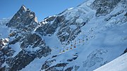
The location near Les Deux Alpes is known as a paradise for freeriding , as there is only a short prepared slope section on the Glacier de la Girose in the entire ski area and the rest of the area is not prepared and at your own risk, taking into account the alpine dangers is freely passable. In addition, it is one of the most famous alpine centers for extreme skiers along with Chamonix because of its long descents with imposing steep slopes, ice gullies ( couloirs ), huge glacier protrusions and crevasses, which make a breathtaking impression due to the surrounding 3,809 m high Le Rateau .
The winter sports infrastructure on the northern slopes of the Meije massif includes a cable car with two sections from 1500 to 3200 m and a drag lift on the Glacier de la Girose up to the Dôme de la Lauze at 3560 m. From there there is a transition to the ski area of Les Deux Alpes . There are refreshment options at the middle and summit station. On one of the standard routes into the valley, on a ledge not far from the small lake Lac de Puy Vachier, there is the Evariste Chancel hut (2508 m), which is also managed. On the sunny terraces north of La Grave there is another small family ski area with two lifts in the hamlet of Le Chazelet.
Events
Derby de la Meije
Every year at the end of March / beginning of April, the Derby de la Meije , a freeride race, takes place in La Grave . The start is from the Dôme de la Lauze at an altitude of 3550 m and there is a difference in altitude of 2100 m down to the valley. An exact route is not specified, the driving time is decisive. The fastest downhill skiers can complete the route in six to seven minutes.
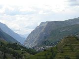
La Grave viewed from the Villar d'Arêne valley
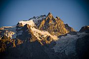
Summit of the Meije , 3982 m

Summit of the Meije in winter

The glacier Glacier de la Girose

Cable car
Cable car in winter
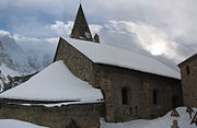
Church of La Grave with a view of the Meije
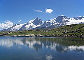
The alpine summit la Meije with Lac Lérié in the foreground


See also
- Barre des Écrins , one of the highest alpine peaks in the Écrins National Park
Web links
- Website of the community
- Website of the La Grave cable car operator
- Website Derby de la Meije
- FAZ.net January 6, 2017: The village above the clouds
Individual evidence
- ↑ La Grave on Les plus Beaux Villages de France (French)
- ^ Website of the community
Ansouis | Bargème | Coaraze | Gassin | Gordes | Gourdon | La Grave-la-Meije | Les Baux-de-Provence | Lourmarin | Ménerbes | Moustiers-Sainte-Marie | Roussillon | Sainte-Agnès | Saint-Véran | Séguret | Seillans | Tour tour | Venasque