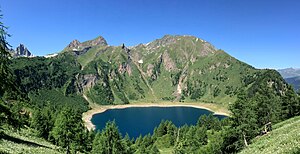
Lake Tremorgio
| Lake Tremorgio | ||
|---|---|---|

|
||
| Lago Tremorgio with Pizzo del Prévat (left back) and the double peaks Poncione di Tremorgio and Pizzo di Mezzodì (left front) | ||
| Geographical location | Ticino | |
| Tributaries | Riale di Tremorgio, various mountain streams | |
| Drain | Riale di Tremorgio → Ticino | |
| Data | ||
| Coordinates | 698 419 / 148341 | |
|
|
||
| Altitude above sea level | 1820 m above sea level M. | |
| surface | 39 ha | |
| volume | 9 million m³ | |
| Maximum depth | 50 m | |
| Catchment area | 5.55 km² | |

|
||
The Lago Tremorgio is an at 1820 m above sea level. M. picturesque mountain lake above Rodi-Fiesso in the municipality of Prato Leventina in Swiss canton of Ticino .
A cable car built in 1966 and renovated in 1999 leads in five minutes from Rodi-Fiesso to the Capanna Tremorgio refuge near the lake. It is a popular starting point for hikes in the Leventina and over the Passo del Campolungo into the Maggia Valley .
Although Lago Tremorgio is not actually a reservoir , part of its water is used to generate electricity in the Tremorgio power plant 850 meters below in the village of Rodi-Fiesso. In the past even a small dam was built, but it is no longer used. The subsoil was unsuitable and there were major water losses through seepage into the ground.
geography
Lake Tremorgio lies in a hollow in the Ticino Alps , bordered by the peaks Pizzo di Mezzodì , Poncione di Tremorgio , Pizzo Meda and Cima di Filo .
It lies in the calcareous Bündner schist from the Mesozoic , which is assigned to the lower Penninic . The rock on the lake shore is mostly covered by debris and on the lake runoff by a largely eroded ground moraine . The subsoil tends to seep away, which is why the water level is lower today. On the current maps of the federal government, the height is 1820 m above sea level. M. and the maximum depth indicated with 50 meters. On the 2011 map it was 1827 m above sea level. M. , which corresponds to a depth of 57 meters, and maps up to the 1990s give 1830 m above sea level. M. at.
Due to the lower water level, the Riale di Tremorgio drains the lake through a channel underground. A newly created hiking trail leads over the former drain, which leads around the lake, partly over the former lake bed. The Riale di Tremorgio is also by far the largest tributary of the mountain lake. It rises from Lago di Leìt below Pizzo Campolungo and takes up a large part of the 5.55 km² catchment area. Next to it, only short mountain streams feed Lake Tremorgio.
Web links
Individual evidence
- ↑ a b c Geoserver of the Swiss Federal Administration ( information )
- ↑ Tremorgio cable car website of the Agenzia turistica ticinese
- ↑ Max Weibel: The Minerals of Switzerland: A mineralogical guide . Springer-Verlag, 2013, p. 216 ( Lago Tremorgio on p. 173 in the Google book search).

